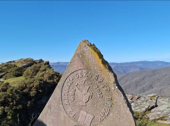
![](/images/other/stat-length.png)
- Randonnées
- A pied
- Espagne
- Navarre
- Inconnu
Inconnu, Navarre, A pied : Les meilleures randonnées, itinéraires, parcours, balades et promenades
Inconnu : découvrez les meilleures randonnées : 57 a pied, 398 marche, 7 marche nordique, 2 course à pied et 2 trail. Tous ces circuits, parcours, itinéraires et activités en plein air sont disponibles dans nos applications SityTrail pour smartphones et tablettes.
Les meilleurs parcours (465)
![Randonnée Marche Baztan - Le Legate 870m et Munho 432m depuis Elizondo/Lekaroz 11/09/2024 - Photo](https://media.geolcdn.com/t/350/260/3a7849ca-5caa-42b4-972a-045a6773fe6b.png&format=jpg&maxdim=2)
![Marche Marche](https://static1.geolcdn.com/sitytour/trail-icons/101.png)
Km
Marche
![](/images/other/stat-length.png)
![](https://static1.geolcdn.com/siteimages/upload/files/1508320355ic_sort_den_pos_24dp.png)
![](https://static1.geolcdn.com/siteimages/upload/files/1508320355ic_sort_den_neg_24dp.png)
![](https://static1.geolcdn.com/siteimages/upload/files/16400158638029165_repeat_loop_refresh_sync_direction_icon.png)
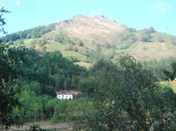
• Au départ de LEKAROZ ( petit village près d'ELIZONDO), circuit ayant pour objectif le LEGATE 870m. On gravira au pass...
![Randonnée Marche Pampelune - C3.5 Pamplune - Puente La Reina - Photo](https://media.geolcdn.com/t/350/260/ext.jpg?maxdim=2&url=https%3A%2F%2Fservices.sitytrail.com%2FGeolivesWS%2FDownloadMedia.ashx%3FTrailID%3D202760%26Media%3Dad54ba77-ddc0-4781-ab5e-3fd1d046408a.jpg)
![Marche Marche](https://static1.geolcdn.com/sitytour/trail-icons/101.png)
Km
Marche
![](/images/other/stat-length.png)
![](https://static1.geolcdn.com/siteimages/upload/files/1508320355ic_sort_den_pos_24dp.png)
![](https://static1.geolcdn.com/siteimages/upload/files/1508320355ic_sort_den_neg_24dp.png)
![](https://static1.geolcdn.com/siteimages/upload/files/16400158638029165_repeat_loop_refresh_sync_direction_icon.png)
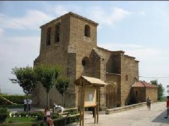
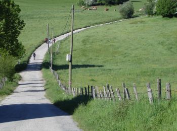
• Campagne vallonnée Pèlerins forgés au point culminant de l'étape Visite de Puente la Reina
![Randonnée Marche Esteribar - C3.4 Zubiri - Pamplune - Photo](https://media.geolcdn.com/t/350/260/ext.jpg?maxdim=2&url=https%3A%2F%2Fservices.sitytrail.com%2FGeolivesWS%2FDownloadMedia.ashx%3FTrailID%3D202757%26Media%3D87a33e27-38ec-4d67-b65f-70c6c3d68bbf.jpg)
![Marche Marche](https://static1.geolcdn.com/sitytour/trail-icons/101.png)
Km
Marche
![](/images/other/stat-length.png)
![](https://static1.geolcdn.com/siteimages/upload/files/1508320355ic_sort_den_pos_24dp.png)
![](https://static1.geolcdn.com/siteimages/upload/files/1508320355ic_sort_den_neg_24dp.png)
![](https://static1.geolcdn.com/siteimages/upload/files/16400158638029165_repeat_loop_refresh_sync_direction_icon.png)
• Vallée et plaine cultivée de l'Arga. Ponts romans Visite de Pampelune
![Randonnée Marche Urdazubi/Urdax - urdax - Photo](https://media.geolcdn.com/t/350/260/eb9329a6-8a81-4e34-9565-1e6fabf40cde.jpg&format=jpg&maxdim=2)
![Marche Marche](https://static1.geolcdn.com/sitytour/trail-icons/101.png)
Km
Marche
![](/images/other/stat-length.png)
![](https://static1.geolcdn.com/siteimages/upload/files/1508320355ic_sort_den_pos_24dp.png)
![](https://static1.geolcdn.com/siteimages/upload/files/1508320355ic_sort_den_neg_24dp.png)
![](https://static1.geolcdn.com/siteimages/upload/files/16400158638029165_repeat_loop_refresh_sync_direction_icon.png)
![Randonnée A pied Erro - Aurizberri/Espinal Esnotz - Photo](https://media.geolcdn.com/t/350/260/03016d11-f902-4de4-bb07-9e817bd9e228.jpeg&format=jpg&maxdim=2)
![A pied A pied](https://static1.geolcdn.com/sitytour/trail-icons/100.png)
Km
A pied
![](/images/other/stat-length.png)
![](https://static1.geolcdn.com/siteimages/upload/files/1508320355ic_sort_den_pos_24dp.png)
![](https://static1.geolcdn.com/siteimages/upload/files/1508320355ic_sort_den_neg_24dp.png)
![](https://static1.geolcdn.com/siteimages/upload/files/16400158638029165_repeat_loop_refresh_sync_direction_icon.png)
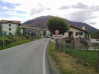
• Randonnée créée par Erroibarko bidexken sarea.
![Randonnée A pied Zubieta - Mendrasako itzulia - Photo](https://media.geolcdn.com/t/350/260/8db24c19-ae27-4ffc-b99b-f43dbed43de3.jpeg&format=jpg&maxdim=2)
![A pied A pied](https://static1.geolcdn.com/sitytour/trail-icons/100.png)
Km
A pied
![](/images/other/stat-length.png)
![](https://static1.geolcdn.com/siteimages/upload/files/1508320355ic_sort_den_pos_24dp.png)
![](https://static1.geolcdn.com/siteimages/upload/files/1508320355ic_sort_den_neg_24dp.png)
![](https://static1.geolcdn.com/siteimages/upload/files/16400158638029165_repeat_loop_refresh_sync_direction_icon.png)
• Symbole: white strip on top of blue strip
![Randonnée A pied Zubieta - Aurkidiko itzulia - Photo](https://media.geolcdn.com/t/350/260/8db24c19-ae27-4ffc-b99b-f43dbed43de3.jpeg&format=jpg&maxdim=2)
![A pied A pied](https://static1.geolcdn.com/sitytour/trail-icons/100.png)
Km
A pied
![](/images/other/stat-length.png)
![](https://static1.geolcdn.com/siteimages/upload/files/1508320355ic_sort_den_pos_24dp.png)
![](https://static1.geolcdn.com/siteimages/upload/files/1508320355ic_sort_den_neg_24dp.png)
![](https://static1.geolcdn.com/siteimages/upload/files/16400158638029165_repeat_loop_refresh_sync_direction_icon.png)
• Symbole: white strip on top of purple strip
![Randonnée A pied Larraun - SL-NA 302 Nacedero del Larraun - Iribas - Photo](https://media.geolcdn.com/t/350/260/640acbd9-1b81-423b-8adf-6c53d0779550.jpeg&format=jpg&maxdim=2)
![A pied A pied](https://static1.geolcdn.com/sitytour/trail-icons/100.png)
Km
A pied
![](/images/other/stat-length.png)
![](https://static1.geolcdn.com/siteimages/upload/files/1508320355ic_sort_den_pos_24dp.png)
![](https://static1.geolcdn.com/siteimages/upload/files/1508320355ic_sort_den_neg_24dp.png)
![](https://static1.geolcdn.com/siteimages/upload/files/16400158638029165_repeat_loop_refresh_sync_direction_icon.png)
• Symbole: white strip on top of green strip
![Randonnée A pied Urbasa - Ruta del Hayedo Encantado - Photo](https://media.geolcdn.com/t/350/260/f7efbb1a-3d3e-4a98-aa16-68e223508a8a.jpeg&format=jpg&maxdim=2)
![A pied A pied](https://static1.geolcdn.com/sitytour/trail-icons/100.png)
Km
A pied
![](/images/other/stat-length.png)
![](https://static1.geolcdn.com/siteimages/upload/files/1508320355ic_sort_den_pos_24dp.png)
![](https://static1.geolcdn.com/siteimages/upload/files/1508320355ic_sort_den_neg_24dp.png)
![](https://static1.geolcdn.com/siteimages/upload/files/16400158638029165_repeat_loop_refresh_sync_direction_icon.png)
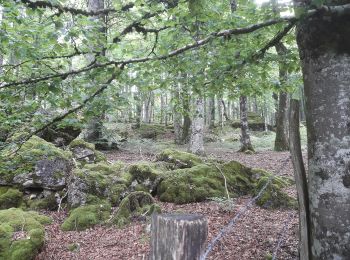
• Site web: http://www.sierraurbasa.com/Hayedo%20encantado.html
![Randonnée A pied Urdazubi/Urdax - SL-NA 15 Otsondottiki - Photo](https://media.geolcdn.com/t/350/260/52f4bcee-e0a0-4b91-9588-fad8a39e9c22.jpeg&format=jpg&maxdim=2)
![A pied A pied](https://static1.geolcdn.com/sitytour/trail-icons/100.png)
Km
A pied
![](/images/other/stat-length.png)
![](https://static1.geolcdn.com/siteimages/upload/files/1508320355ic_sort_den_pos_24dp.png)
![](https://static1.geolcdn.com/siteimages/upload/files/1508320355ic_sort_den_neg_24dp.png)
![](https://static1.geolcdn.com/siteimages/upload/files/16400158638029165_repeat_loop_refresh_sync_direction_icon.png)
• Symbole: white strip on top of green strip
![Randonnée A pied Baztan - SL-NA 14 Le tour de l'Azkar - Photo](https://media.geolcdn.com/t/350/260/35dd0ce1-14a9-48e7-90fb-900f8c18165c.jpeg&format=jpg&maxdim=2)
![A pied A pied](https://static1.geolcdn.com/sitytour/trail-icons/100.png)
Km
A pied
![](/images/other/stat-length.png)
![](https://static1.geolcdn.com/siteimages/upload/files/1508320355ic_sort_den_pos_24dp.png)
![](https://static1.geolcdn.com/siteimages/upload/files/1508320355ic_sort_den_neg_24dp.png)
![](https://static1.geolcdn.com/siteimages/upload/files/16400158638029165_repeat_loop_refresh_sync_direction_icon.png)
• Symbole: white strip on top of green strip
![Randonnée A pied Urdazubi/Urdax - SL-NA 17 Axularren - Photo](https://media.geolcdn.com/t/350/260/4ea81041-0789-4918-a312-4afe472a85c1.jpeg&format=jpg&maxdim=2)
![A pied A pied](https://static1.geolcdn.com/sitytour/trail-icons/100.png)
Km
A pied
![](/images/other/stat-length.png)
![](https://static1.geolcdn.com/siteimages/upload/files/1508320355ic_sort_den_pos_24dp.png)
![](https://static1.geolcdn.com/siteimages/upload/files/1508320355ic_sort_den_neg_24dp.png)
![](https://static1.geolcdn.com/siteimages/upload/files/16400158638029165_repeat_loop_refresh_sync_direction_icon.png)
• Symbole: white strip on top of green strip
![Randonnée A pied Baztan - SL-NA 12 Xorroxin - Photo](https://media.geolcdn.com/t/350/260/c70a4708-6618-4ddb-8631-b64345aa0ab6.jpeg&format=jpg&maxdim=2)
![A pied A pied](https://static1.geolcdn.com/sitytour/trail-icons/100.png)
Km
A pied
![](/images/other/stat-length.png)
![](https://static1.geolcdn.com/siteimages/upload/files/1508320355ic_sort_den_pos_24dp.png)
![](https://static1.geolcdn.com/siteimages/upload/files/1508320355ic_sort_den_neg_24dp.png)
![](https://static1.geolcdn.com/siteimages/upload/files/16400158638029165_repeat_loop_refresh_sync_direction_icon.png)
• Symbole: white strip on top of green strip
![Randonnée A pied Igantzi - SL-NA 1 San Juan Xar - Photo](https://media.geolcdn.com/t/350/260/86ed5051-bb8b-4091-bfae-3c269df51ddb.jpeg&format=jpg&maxdim=2)
![A pied A pied](https://static1.geolcdn.com/sitytour/trail-icons/100.png)
Km
A pied
![](/images/other/stat-length.png)
![](https://static1.geolcdn.com/siteimages/upload/files/1508320355ic_sort_den_pos_24dp.png)
![](https://static1.geolcdn.com/siteimages/upload/files/1508320355ic_sort_den_neg_24dp.png)
![](https://static1.geolcdn.com/siteimages/upload/files/16400158638029165_repeat_loop_refresh_sync_direction_icon.png)
• Symbole: white strip on top of green strip
![Randonnée A pied Urrotz - SL-NA 7 Leurtzako ibilbidea - Photo](https://media.geolcdn.com/t/350/260/fb1e8c87-4fad-47a1-b5ba-82d93accfdfb.jpeg&format=jpg&maxdim=2)
![A pied A pied](https://static1.geolcdn.com/sitytour/trail-icons/100.png)
Km
A pied
![](/images/other/stat-length.png)
![](https://static1.geolcdn.com/siteimages/upload/files/1508320355ic_sort_den_pos_24dp.png)
![](https://static1.geolcdn.com/siteimages/upload/files/1508320355ic_sort_den_neg_24dp.png)
![](https://static1.geolcdn.com/siteimages/upload/files/16400158638029165_repeat_loop_refresh_sync_direction_icon.png)
• Symbole: white strip on top of green strip
![Randonnée A pied Etxalar - SL-NA 5 Argarata - Santa Krutz - Photo](https://media.geolcdn.com/t/350/260/94bbb8c0-a5b3-4c45-bc43-34bd6d9df6cd.jpeg&format=jpg&maxdim=2)
![A pied A pied](https://static1.geolcdn.com/sitytour/trail-icons/100.png)
Km
A pied
![](/images/other/stat-length.png)
![](https://static1.geolcdn.com/siteimages/upload/files/1508320355ic_sort_den_pos_24dp.png)
![](https://static1.geolcdn.com/siteimages/upload/files/1508320355ic_sort_den_neg_24dp.png)
![](https://static1.geolcdn.com/siteimages/upload/files/16400158638029165_repeat_loop_refresh_sync_direction_icon.png)
• Symbole: white strip on top of green strip
![Randonnée Marche Urdazubi/Urdax - Urdax Lizartzu circuit des bunkers - Photo](https://media.geolcdn.com/t/350/260/ext.jpg?maxdim=2&url=https%3A%2F%2Fservices.sitytrail.com%2FGeolivesWS%2FDownloadMedia.ashx%3FTrailID%3D892962%26Media%3Dc7436390-fb72-4d0d-9b84-00caadd8f947.jpg)
![Marche Marche](https://static1.geolcdn.com/sitytour/trail-icons/101.png)
Km
Marche
![](/images/other/stat-length.png)
![](https://static1.geolcdn.com/siteimages/upload/files/1508320355ic_sort_den_pos_24dp.png)
![](https://static1.geolcdn.com/siteimages/upload/files/1508320355ic_sort_den_neg_24dp.png)
![](https://static1.geolcdn.com/siteimages/upload/files/16400158638029165_repeat_loop_refresh_sync_direction_icon.png)
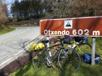
• randonnée classique autour de urdax passant par Lizartzu et la crete qui mène au col d'otsondo en surplombant la vall...
![Randonnée Marche Urdazubi/Urdax - Boucle au sud d'Urdax - Photo](https://media.geolcdn.com/t/350/260/ext.jpg?maxdim=2&url=https%3A%2F%2Fservices.sitytrail.com%2FGeolivesWS%2FDownloadMedia.ashx%3FTrailID%3D896614%26Media%3D91fefb7a-2db5-4c01-9cb7-918d34f0cda3.jpg)
![Marche Marche](https://static1.geolcdn.com/sitytour/trail-icons/101.png)
Km
Marche
![](/images/other/stat-length.png)
![](https://static1.geolcdn.com/siteimages/upload/files/1508320355ic_sort_den_pos_24dp.png)
![](https://static1.geolcdn.com/siteimages/upload/files/1508320355ic_sort_den_neg_24dp.png)
![](https://static1.geolcdn.com/siteimages/upload/files/16400158638029165_repeat_loop_refresh_sync_direction_icon.png)
• par four à chaux, fontaine, Urdazubiko Muga, Mokorro, Otsondo.
![Marche Marche](https://static1.geolcdn.com/sitytour/trail-icons/101.png)
Km
Marche
![](/images/other/stat-length.png)
![](https://static1.geolcdn.com/siteimages/upload/files/1508320355ic_sort_den_pos_24dp.png)
![](https://static1.geolcdn.com/siteimages/upload/files/1508320355ic_sort_den_neg_24dp.png)
![](https://static1.geolcdn.com/siteimages/upload/files/16400158638029165_repeat_loop_refresh_sync_direction_icon.png)
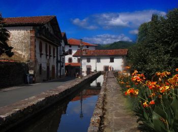
• à effectuer en sens inverse horaire (par la gauche) A mon goût, l'endroit est l'un des plus beaux de Navarre avec son...
![Randonnée Marche Urbasa - Arche de Portupekoleze et grotte de Lezaundi de la venta de Lizarraga - Photo](https://media.geolcdn.com/t/350/260/75529867-0d72-4e6e-9500-320394cb120a.jpg&format=jpg&maxdim=2)
![Marche Marche](https://static1.geolcdn.com/sitytour/trail-icons/101.png)
Km
Marche
![](/images/other/stat-length.png)
![](https://static1.geolcdn.com/siteimages/upload/files/1508320355ic_sort_den_pos_24dp.png)
![](https://static1.geolcdn.com/siteimages/upload/files/1508320355ic_sort_den_neg_24dp.png)
![](https://static1.geolcdn.com/siteimages/upload/files/16400158638029165_repeat_loop_refresh_sync_direction_icon.png)
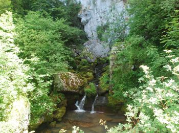
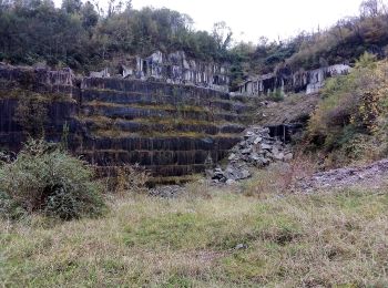
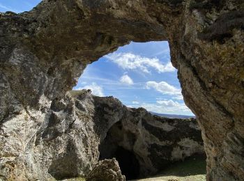
• Arc de Portupekoleze et grotte de Lezaundi à venta Lizarraga C'est un endroit magnifique ! Il est un peu caché même s...
20 randonnées affichées sur 465
Application GPS de randonnée GRATUITE
Activités
Régions proches
- Abárzuza/Abartzuza
- Abaurregaina / Abaurrea Alta
- Abaurrepea / Abaurrea Baja
- Aibar/Oibar
- Allín / Allin
- Altsasu/Alsasua
- Améscoa Baja
- Andia
- Anue
- Aoiz/Agoitz
- Araitz
- Arakil
- Arano
- Arantza
- Arce/Artzi
- Arguedas
- Aria
- Aribe
- Armañanzas
- Arróniz
- Artajona
- Auritz
- Ayegui
- Ayesa
- Bakaiku
- Bardenas Reales de Navarra
- Bargota
- Basaburua
- Baztan
- Beintza-Labaien
- Bera
- Beriáin
- Berrioplano
- Berriozar
- Bertizarana
- Burgui/Burgi
- Burlada/Burlata
- Cabanillas
- Cadreita
- Caparroso
- Carcastillo
- Cáseda
- Castejón
- Cirauqui
- Cizur
- Corella
- Cortes
- Donamaria
- Doneztebe/Santesteban
- Elgorriaga
- Enériz/Eneritz
- Ergoiena
- Erro
- Estella-Lizarra
- Esteribar
- Etxalar
- Etxarri-Aranatz
- Ezcabarte
- Ezcároz/Ezkaroze
- Ezkurra
- Facería 22
- Facería 87
- Facería 9
- Facería 91
- Fitero
- Fustiñana
- Galar
- Gallipienzo
- Gallués/Galoze
- Garaioa
- Garde
- Garralda
- Goizueta
- Güesa/Gorza
- Guesálaz
- Hiriberri/Villanueva de Aezkoa
- Huarte/Uharte
- Ibargoiti
- Igantzi
- Igúzquiza
- Irañeta
- Irurtzun
- Isaba/Izaba
- Ituren
- Iturmendi
- Iza
- Jaurrieta
- Javier
- Lapoblación
- Larraun
- Leatxe/Leache
- Legarda
- Leitza
- Lekunberri
- Leoz
- Lesaka
- Lezaun
- Liédena
- Los Arcos
- Lumbier
- Luquin
- Luzaide
- Mañeru
- Marañón
- Massif d'Aralar
- Mélida
- Mendigorria
- Monreal
- Monte Común de las Améscoas/Ameskoa mendiak
- Murillo el Cuende
- Muruzábal
- Navascués / Nabaskoze
- Noáin (Valle de Elorz)/Noain (Elortzibar)
- Obanos
- Ochagavía/Otsagabia
- Oitz
- Olaldea
- Olite/Erriberri
- Orbaizeta
- Orbara
- Oroz-Betelu / Orotz-Betelu
- Pampelune
- Petilla de Aragón
- Puente la Reina/Gares
- Romanzado
- Roncal/Erronkari
- Roncevaux
- San Martín de Unx
- Sangüesa/Zangoza
- Sansol
- Sarriés/Sartze
- Sunbilla
- Tafalla
- Tiebas-Muruarte de Reta
- Tirapu
- Torralba del Río
- Torres del Río
- Tudela
- Uharte-Arakil
- Ujué / Uxue
- Ultzama
- Urbasa
- Urdazubi/Urdax
- Urdiain
- Urraul Alto
- Urraul Bajo
- Urrotz
- Urroz
- Uterga
- Uztárroz/Uztarroze
- Valle de Ollo/Ollaran
- Valle de Yerri / Deierri
- Valtierra
- Viana
- Vidángoz/Bidankoze
- Villafranca
- Villamayor de Monjardín
- Villatuerta
- Villava/Atarrabia
- Yesa
- Zizur Mayor/Zizur Nagusia
- Zubieta
- Zugarramurdi