![](/images/other/stat-length.png)
- Randonnées
- Vélo
- France
- Provence-Alpes-Côte d'Azur
- Alpes-de-Haute-Provence
Alpes-de-Haute-Provence, Provence-Alpes-Côte d'Azur, Vélo : Les meilleures randonnées, itinéraires, parcours, balades et promenades
Alpes-de-Haute-Provence : découvrez les meilleures randonnées : 121 vélo, 68 vélo de route, 772 v.t.t., 22 v.t.c., 13 cyclotourisme et 86 vélo électrique. Tous ces circuits, parcours, itinéraires et activités en plein air sont disponibles dans nos applications SityTrail pour smartphones et tablettes.
Les meilleurs parcours (1078)
![Randonnée Vélo Forcalquier - Parcours n°17 - Forcalquier - Photo](https://media.geolcdn.com/t/350/260/ext.jpg?maxdim=2&url=https%3A%2F%2Fservices.sitytrail.com%2FGeolivesWS%2FDownloadMedia.ashx%3FTrailID%3D375418%26Media%3D84c90ab1-7dbd-443e-924d-85d77bb4fdae.jpg)
![Vélo Vélo](https://static1.geolcdn.com/sitytour/trail-icons/200.png)
Km
Vélo
![](/images/other/stat-length.png)
![](https://static1.geolcdn.com/siteimages/upload/files/1508320355ic_sort_den_pos_24dp.png)
![](https://static1.geolcdn.com/siteimages/upload/files/1508320355ic_sort_den_neg_24dp.png)
![](https://static1.geolcdn.com/siteimages/upload/files/16400158638029165_repeat_loop_refresh_sync_direction_icon.png)
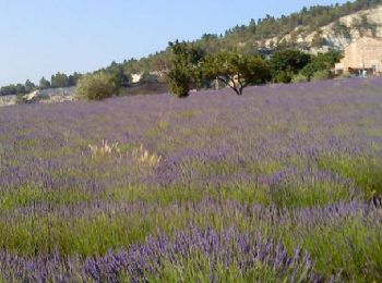
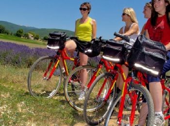
• Découverte des villages et des paysages typiques du pays de Haute-Provence au travers de vastes champs de lavandes, d...
![Randonnée Vélo Saint-André-les-Alpes - Le tour des Thorames - Saint André les Alpes - Photo](https://media.geolcdn.com/t/350/260/ext.jpg?maxdim=2&url=https%3A%2F%2Fservices.sitytrail.com%2FGeolivesWS%2FDownloadMedia.ashx%3FTrailID%3D112777%26Media%3D12327_6.jpg)
![Vélo Vélo](https://static1.geolcdn.com/sitytour/trail-icons/200.png)
Km
Vélo
![](/images/other/stat-length.png)
![](https://static1.geolcdn.com/siteimages/upload/files/1508320355ic_sort_den_pos_24dp.png)
![](https://static1.geolcdn.com/siteimages/upload/files/1508320355ic_sort_den_neg_24dp.png)
![](https://static1.geolcdn.com/siteimages/upload/files/16400158638029165_repeat_loop_refresh_sync_direction_icon.png)
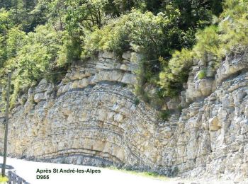
• Ce circuit vous est proposé par l'Office de Tourisme de Saint-André Les Alpes. Départ de l'office de Tourisme de Sain...
![V.T.T. V.T.T.](https://static1.geolcdn.com/sitytour/trail-icons/202.png)
Km
V.T.T.
![](/images/other/stat-length.png)
![](https://static1.geolcdn.com/siteimages/upload/files/1508320355ic_sort_den_pos_24dp.png)
![](https://static1.geolcdn.com/siteimages/upload/files/1508320355ic_sort_den_neg_24dp.png)
![](https://static1.geolcdn.com/siteimages/upload/files/16400158638029165_repeat_loop_refresh_sync_direction_icon.png)
• Bonnet Vert Circuit VTT FFC n°10
![Randonnée V.T.T. Forcalquier - La classique du Clot, circuit n°5 - Pays de Forcalquier - Photo](https://media.geolcdn.com/t/350/260/ext.jpg?maxdim=2&url=https%3A%2F%2Fservices.sitytrail.com%2FGeolivesWS%2FDownloadMedia.ashx%3FTrailID%3D214952%26Media%3D15520_2.jpg)
![V.T.T. V.T.T.](https://static1.geolcdn.com/sitytour/trail-icons/202.png)
Km
V.T.T.
![](/images/other/stat-length.png)
![](https://static1.geolcdn.com/siteimages/upload/files/1508320355ic_sort_den_pos_24dp.png)
![](https://static1.geolcdn.com/siteimages/upload/files/1508320355ic_sort_den_neg_24dp.png)
![](https://static1.geolcdn.com/siteimages/upload/files/16400158638029165_repeat_loop_refresh_sync_direction_icon.png)
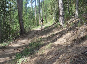
• Départ de l'Office de Tourisme. Monter au Clot de Melly est une habitude pour ton bon VTTiste forcalquiéren. La piste...
![Randonnée V.T.T. Gréoux-les-Bains - De Gréoux les Bains au Lac d'Esparron - Photo](https://media.geolcdn.com/t/350/260/ext.jpg?maxdim=2&url=https%3A%2F%2Fservices.sitytrail.com%2FGeolivesWS%2FDownloadMedia.ashx%3FTrailID%3D129876%26Media%3D13444_1.jpg)
![V.T.T. V.T.T.](https://static1.geolcdn.com/sitytour/trail-icons/202.png)
Km
V.T.T.
![](/images/other/stat-length.png)
![](https://static1.geolcdn.com/siteimages/upload/files/1508320355ic_sort_den_pos_24dp.png)
![](https://static1.geolcdn.com/siteimages/upload/files/1508320355ic_sort_den_neg_24dp.png)
![](https://static1.geolcdn.com/siteimages/upload/files/16400158638029165_repeat_loop_refresh_sync_direction_icon.png)
• Balade facile, de Gréoux les Bains vers le lac d'Esparron, avec un retour par la chapelle de Notre Dame des Œufs.
![Randonnée V.T.T. Jausiers - Espace VTT FFC Vallée de l'Ubaye - Circuit n° 01 - La Tour des Sagnes - Photo](https://media.geolcdn.com/t/350/260/ext.jpg?maxdim=2&url=https%3A%2F%2Fservices.sitytrail.com%2FGeolivesWS%2FDownloadMedia.ashx%3FTrailID%3D102299%26Media%3D2764_1.jpg)
![V.T.T. V.T.T.](https://static1.geolcdn.com/sitytour/trail-icons/202.png)
Km
V.T.T.
![](/images/other/stat-length.png)
![](https://static1.geolcdn.com/siteimages/upload/files/1508320355ic_sort_den_pos_24dp.png)
![](https://static1.geolcdn.com/siteimages/upload/files/1508320355ic_sort_den_neg_24dp.png)
![](https://static1.geolcdn.com/siteimages/upload/files/16400158638029165_repeat_loop_refresh_sync_direction_icon.png)
• Espace VTT FFC Vallée de l’Ubaye Circuit officiel labellisé par la Fédération Française de Cyclisme. La Vallée de l'U...
![Randonnée V.T.T. Méolans-Revel - tour au sud de Méolans - Photo](https://media.geolcdn.com/t/350/260/ext.jpg?maxdim=2&url=https%3A%2F%2Fstatic1.geolcdn.com%2Fsiteimages%2Fupload%2Ffiles%2F1524743154velo.jpg)
![V.T.T. V.T.T.](https://static1.geolcdn.com/sitytour/trail-icons/202.png)
Km
V.T.T.
![](/images/other/stat-length.png)
![](https://static1.geolcdn.com/siteimages/upload/files/1508320355ic_sort_den_pos_24dp.png)
![](https://static1.geolcdn.com/siteimages/upload/files/1508320355ic_sort_den_neg_24dp.png)
![](https://static1.geolcdn.com/siteimages/upload/files/16400158638029165_repeat_loop_refresh_sync_direction_icon.png)
• Tour sans aucune difficulté
![V.T.T. V.T.T.](https://static1.geolcdn.com/sitytour/trail-icons/202.png)
Km
V.T.T.
![](/images/other/stat-length.png)
![](https://static1.geolcdn.com/siteimages/upload/files/1508320355ic_sort_den_pos_24dp.png)
![](https://static1.geolcdn.com/siteimages/upload/files/1508320355ic_sort_den_neg_24dp.png)
![](https://static1.geolcdn.com/siteimages/upload/files/16400158638029165_repeat_loop_refresh_sync_direction_icon.png)
• Voilà une randonnée VTT sur le village de Castellane une sortie VTT qui combine 3 circuits de l'office du tourisme . ...
![Randonnée V.T.T. Thorame-Basse - Camping petit cordeil Argens - Photo](https://media.geolcdn.com/t/350/260/3c30eacb-045b-4112-8527-eaa21f175197.jpg&format=jpg&maxdim=2)
![V.T.T. V.T.T.](https://static1.geolcdn.com/sitytour/trail-icons/202.png)
Km
V.T.T.
![](/images/other/stat-length.png)
![](https://static1.geolcdn.com/siteimages/upload/files/1508320355ic_sort_den_pos_24dp.png)
![](https://static1.geolcdn.com/siteimages/upload/files/1508320355ic_sort_den_neg_24dp.png)
![](https://static1.geolcdn.com/siteimages/upload/files/16400158638029165_repeat_loop_refresh_sync_direction_icon.png)
• Terrain cassant mais quelle vue en haut du petit cordeil .Très beau village d'Argens.
![Randonnée V.T.T. Volx - Volx/Montaigu/Bellevue/La Garde - Photo](https://media.geolcdn.com/t/350/260/ext.jpg?maxdim=2&url=https%3A%2F%2Fstatic1.geolcdn.com%2Fsiteimages%2Fupload%2Ffiles%2F1524743154velo.jpg)
![V.T.T. V.T.T.](https://static1.geolcdn.com/sitytour/trail-icons/202.png)
Km
V.T.T.
![](/images/other/stat-length.png)
![](https://static1.geolcdn.com/siteimages/upload/files/1508320355ic_sort_den_pos_24dp.png)
![](https://static1.geolcdn.com/siteimages/upload/files/1508320355ic_sort_den_neg_24dp.png)
![](https://static1.geolcdn.com/siteimages/upload/files/16400158638029165_repeat_loop_refresh_sync_direction_icon.png)
• Belle Randonnée Variée. Montée par un chemin Forestier qui se transforme en Single track pour la descente. Quelques p...
![Randonnée V.T.T. Uvernet-Fours - Verdon - Grande traversée TransVerdon - du Col d'Allos à Val d'Allos - Photo](https://media.geolcdn.com/t/350/260/ext.jpg?maxdim=2&url=https%3A%2F%2Fstatic1.geolcdn.com%2Fsiteimages%2Fupload%2Ffiles%2F1524743154velo.jpg)
![V.T.T. V.T.T.](https://static1.geolcdn.com/sitytour/trail-icons/202.png)
Km
V.T.T.
![](/images/other/stat-length.png)
![](https://static1.geolcdn.com/siteimages/upload/files/1508320355ic_sort_den_pos_24dp.png)
![](https://static1.geolcdn.com/siteimages/upload/files/1508320355ic_sort_den_neg_24dp.png)
![](https://static1.geolcdn.com/siteimages/upload/files/16400158638029165_repeat_loop_refresh_sync_direction_icon.png)
![Randonnée V.T.T. Lurs - Lurs/Tour de la Beaume - Photo](https://media.geolcdn.com/t/350/260/ext.jpg?maxdim=2&url=https%3A%2F%2Fstatic1.geolcdn.com%2Fsiteimages%2Fupload%2Ffiles%2F1524743154velo.jpg)
![V.T.T. V.T.T.](https://static1.geolcdn.com/sitytour/trail-icons/202.png)
Km
V.T.T.
![](/images/other/stat-length.png)
![](https://static1.geolcdn.com/siteimages/upload/files/1508320355ic_sort_den_pos_24dp.png)
![](https://static1.geolcdn.com/siteimages/upload/files/1508320355ic_sort_den_neg_24dp.png)
![](https://static1.geolcdn.com/siteimages/upload/files/16400158638029165_repeat_loop_refresh_sync_direction_icon.png)
• Circuit roulant (surtout la 2 eme partie composée de gros chemins)
![Randonnée Vélo Forcalquier - Forcalquier - Lure à vélo - Photo](https://media.geolcdn.com/t/350/260/ext.jpg?maxdim=2&url=https%3A%2F%2Fservices.sitytrail.com%2FGeolivesWS%2FDownloadMedia.ashx%3FTrailID%3D375430%26Media%3D23b539a2-af76-456a-868b-6b919a4761e7.jpg)
![Vélo Vélo](https://static1.geolcdn.com/sitytour/trail-icons/200.png)
Km
Vélo
![](/images/other/stat-length.png)
![](https://static1.geolcdn.com/siteimages/upload/files/1508320355ic_sort_den_pos_24dp.png)
![](https://static1.geolcdn.com/siteimages/upload/files/1508320355ic_sort_den_neg_24dp.png)
![](https://static1.geolcdn.com/siteimages/upload/files/16400158638029165_repeat_loop_refresh_sync_direction_icon.png)
• Un itinéraire contrasté, authentique ! Des hautes plaines provençales vous découvrirez la grande variété de leurs pay...
![Randonnée V.T.T. Quinson - grillon2 - Photo](https://media.geolcdn.com/t/350/260/ext.jpg?maxdim=2&url=https%3A%2F%2Fstatic1.geolcdn.com%2Fsiteimages%2Fupload%2Ffiles%2F1524743154velo.jpg)
![V.T.T. V.T.T.](https://static1.geolcdn.com/sitytour/trail-icons/202.png)
Km
V.T.T.
![](/images/other/stat-length.png)
![](https://static1.geolcdn.com/siteimages/upload/files/1508320355ic_sort_den_pos_24dp.png)
![](https://static1.geolcdn.com/siteimages/upload/files/1508320355ic_sort_den_neg_24dp.png)
![](https://static1.geolcdn.com/siteimages/upload/files/16400158638029165_repeat_loop_refresh_sync_direction_icon.png)
• quinson - dir. montméyan - les 3 villa - GR99 - plateau malasoque - ravin ste maxime - retour la roquette - route de ...
![Randonnée V.T.T. Gréoux-les-Bains - VTT Single spirit - Gréoux les Bains - Photo](https://media.geolcdn.com/t/350/260/ext.jpg?maxdim=2&url=https%3A%2F%2Fstatic1.geolcdn.com%2Fsiteimages%2Fupload%2Ffiles%2F1524743154velo.jpg)
![V.T.T. V.T.T.](https://static1.geolcdn.com/sitytour/trail-icons/202.png)
Km
V.T.T.
![](/images/other/stat-length.png)
![](https://static1.geolcdn.com/siteimages/upload/files/1508320355ic_sort_den_pos_24dp.png)
![](https://static1.geolcdn.com/siteimages/upload/files/1508320355ic_sort_den_neg_24dp.png)
![](https://static1.geolcdn.com/siteimages/upload/files/16400158638029165_repeat_loop_refresh_sync_direction_icon.png)
• Superbe parcours inédit du site VTT avec presque que des singles. L'incontournable de Gréoux pour le plaisir du pilot...
![Randonnée V.T.T. Digne-les-Bains - Terres Noires 2011 (50km) - Photo](https://media.geolcdn.com/t/350/260/ext.jpg?maxdim=2&url=https%3A%2F%2Fstatic1.geolcdn.com%2Fsiteimages%2Fupload%2Ffiles%2F1524743154velo.jpg)
![V.T.T. V.T.T.](https://static1.geolcdn.com/sitytour/trail-icons/202.png)
Km
V.T.T.
![](/images/other/stat-length.png)
![](https://static1.geolcdn.com/siteimages/upload/files/1508320355ic_sort_den_pos_24dp.png)
![](https://static1.geolcdn.com/siteimages/upload/files/1508320355ic_sort_den_neg_24dp.png)
![](https://static1.geolcdn.com/siteimages/upload/files/16400158638029165_repeat_loop_refresh_sync_direction_icon.png)
• Ce parcours réussi à associer tous ce que j'attends lors d'une sortie. A savoir originalité, beauté et amusement. Ori...
![Randonnée V.T.C. Sisteron - tour de la baume - Photo](https://media.geolcdn.com/t/350/260/ext.jpg?maxdim=2&url=https%3A%2F%2Fstatic1.geolcdn.com%2Fsiteimages%2Fupload%2Ffiles%2F1524743154velo.jpg)
![V.T.C. V.T.C.](https://static1.geolcdn.com/sitytour/trail-icons/203.png)
Km
V.T.C.
![](/images/other/stat-length.png)
![](https://static1.geolcdn.com/siteimages/upload/files/1508320355ic_sort_den_pos_24dp.png)
![](https://static1.geolcdn.com/siteimages/upload/files/1508320355ic_sort_den_neg_24dp.png)
![](https://static1.geolcdn.com/siteimages/upload/files/16400158638029165_repeat_loop_refresh_sync_direction_icon.png)
![Randonnée V.T.T. Montfort - Montfort/Puimichel par les collines - Photo](https://media.geolcdn.com/t/350/260/85e8a256-408f-4207-bb7d-2b8c16ee95d1.jpg&format=jpg&maxdim=2)
![V.T.T. V.T.T.](https://static1.geolcdn.com/sitytour/trail-icons/202.png)
Km
V.T.T.
![](/images/other/stat-length.png)
![](https://static1.geolcdn.com/siteimages/upload/files/1508320355ic_sort_den_pos_24dp.png)
![](https://static1.geolcdn.com/siteimages/upload/files/1508320355ic_sort_den_neg_24dp.png)
![](https://static1.geolcdn.com/siteimages/upload/files/16400158638029165_repeat_loop_refresh_sync_direction_icon.png)
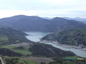
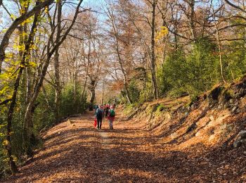
• Jolie balade automnale
![Randonnée Vélo électrique Jausiers - Flavi Barcelonnette - Photo](https://media.geolcdn.com/t/350/260/c8c960c1-cd70-45b7-be5e-7238e8edcc3d.jpg&format=jpg&maxdim=2)
![Vélo électrique Vélo électrique](https://static1.geolcdn.com/sitytour/trail-icons/205.png)
Km
Vélo électrique
![](/images/other/stat-length.png)
![](https://static1.geolcdn.com/siteimages/upload/files/1508320355ic_sort_den_pos_24dp.png)
![](https://static1.geolcdn.com/siteimages/upload/files/1508320355ic_sort_den_neg_24dp.png)
![](https://static1.geolcdn.com/siteimages/upload/files/16400158638029165_repeat_loop_refresh_sync_direction_icon.png)
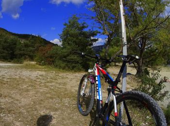
• magnifique parcours,distance réelle 24km. pistes carrossables . efforts moyens.traverseés de petits hameaux magnifiq...
20 randonnées affichées sur 1078
Application GPS de randonnée GRATUITE
Activités
Régions proches
- Aiglun
- Allemagne-en-Provence
- Allons
- Allos
- Angles
- Annot
- Archail
- Aubenas-les-Alpes
- Aubignosc
- Authon
- Auzet
- Banon
- Barcelonnette
- Barles
- Barras
- Barrême
- Bayons
- Beaujeu
- Beauvezer
- Bellaffaire
- Bevons
- Beynes
- Blieux
- Bras-d'Asse
- Braux
- Brunet
- Castellane
- Castellet-lès-Sausses
- Céreste
- Champtercier
- Château-Arnoux-Saint-Auban
- Châteaufort
- Châteauneuf-Miravail
- Châteauneuf-Val-Saint-Donat
- Châteauredon
- Chaudon-Norante
- Clamensane
- Claret
- Clumanc
- Colmars
- Corbières-en-Provence
- Cruis
- Curbans
- Curel
- Dauphin
- Demandolx
- Digne-les-Bains
- Draix
- Enchastrayes
- Entrages
- Entrepierres
- Entrevaux
- Entrevennes
- Esparron-de-Verdon
- Estoublon
- Faucon-de-Barcelonnette
- Faucon-du-Caire
- Fontienne
- Forcalquier
- Ganagobie
- Gigors
- Gréoux-les-Bains
- Hautes-Duyes
- Jausiers
- L'Escale
- L'Hospitalet
- La Brillanne
- La Condamine-Châtelard
- La Garde
- La Javie
- La Motte-du-Caire
- La Mure-Argens
- La Palud-sur-Verdon
- La Robine-sur-Galabre
- La Rochegiron
- La Rochette
- Lambruisse
- Lardiers
- Le Brusquet
- Le Caire
- Le Castellard-Mélan
- Le Castellet
- Le Chaffaut-Saint-Jurson
- Le Fugeret
- Le Lauzet-Ubaye
- Le Vernet
- Les Mées
- Les Omergues
- Les Thuiles
- Limans
- Lurs
- Majastres
- Malijai
- Mallefougasse-Augès
- Mallemoisson
- Mane
- Manosque
- Marcoux
- Méailles
- Melve
- Méolans-Revel
- Mézel
- Mirabeau
- Mison
- Montagnac-Montpezat
- Montclar
- Montfort
- Montfuron
- Montjustin
- Montlaux
- Montsalier
- Moriez
- Moustiers-Sainte-Marie
- Nibles
- Niozelles
- Noyers-sur-Jabron
- Ongles
- Oppedette
- Oraison
- Peipin
- Peyroules
- Peyruis
- Piégut
- Pierrerue
- Pierrevert
- Pontis
- Prads-Haute-Bléone
- Puimichel
- Puimoisson
- Quinson
- Redortiers
- Reillanne
- Revest-Saint-Martin
- Revest-des-Brousses
- Revest-du-Bion
- Riez
- Rougon
- Roumoules
- Saint-André-les-Alpes
- Saint-Benoît
- Saint-Étienne-les-Orgues
- Saint-Geniez
- Saint-Jacques
- Saint-Jeannet
- Saint-Julien-d'Asse
- Saint-Julien-du-Verdon
- Saint-Jurs
- Saint-Laurent-du-Verdon
- Saint-Lions
- Saint-Maime
- Saint-Martin-de-Brômes
- Saint-Martin-les-Eaux
- Saint-Martin-lès-Seyne
- Saint-Michel-l'Observatoire
- Saint-Paul-sur-Ubaye
- Saint-Pierre
- Saint-Pons
- Saint-Vincent-sur-Jabron
- Sainte-Croix-à-Lauze
- Sainte-Croix-du-Verdon
- Sainte-Tulle
- Salignac
- Saumane
- Sausses
- Selonnet
- Senez
- Seyne
- Sigonce
- Sigoyer
- Simiane-la-Rotonde
- Sisteron
- Soleilhas
- Sourribes
- Tartonne
- Thèze
- Thoard
- Thorame-Basse
- Thorame-Haute
- Turriers
- Ubaye-Serre-Ponçon
- Ubraye
- Uvernet-Fours
- Vachères
- Val-d'Oronaye
- Val-de-Chalvagne
- Valavoire
- Valbelle
- Valensole
- Valernes
- Vaumeilh
- Venterol
- Verdaches
- Vergons
- Villars-Colmars
- Villemus
- Villeneuve
- Volonne
- Volx