boucle autour du Cucurucull
PVERTICAL
User
Length
12.8 km
Max alt
2366 m
Uphill gradient
1062 m
Km-Effort
27 km
Min alt
1316 m
Downhill gradient
1062 m
Boucle
Yes
Creation date :
2018-04-17 19:46:10.548
Updated on :
2018-04-17 19:46:10.548
7h21
Difficulty : Difficult
FREE GPS app for hiking
About
Trail Snowshoes of 12.8 km to be discovered at Occitania, Pyrénées-Orientales, Fontpédrouse. This trail is proposed by PVERTICAL.
Description
depuis Prats Balaguer et ascension du col Mitja - bien respecter le sens de la boucle (moins difficile) - possiblité de ne pas faire le col de Mitja
Positioning
Country:
France
Region :
Occitania
Department/Province :
Pyrénées-Orientales
Municipality :
Fontpédrouse
Location:
Unknown
Start:(Dec)
Start:(UTM)
431956 ; 4705493 (31T) N.
Comments
Trails nearby
boucle des gorges de Caranca
Walking
Medium
(2)
Thuès-Entre-Valls,
Occitania,
Pyrénées-Orientales,
France
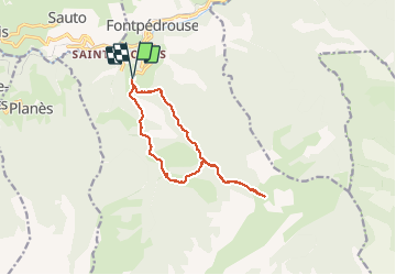
7.2 km | 15.3 km-effort
3h 1min
Yes
Gorges de la garanca
Walking
Very easy
(1)
Thuès-Entre-Valls,
Occitania,
Pyrénées-Orientales,
France
6.7 km | 13.1 km-effort
3h 39min
No
Tour du Cucurucull
Walking
Medium
(1)
Fontpédrouse,
Occitania,
Pyrénées-Orientales,
France
9.3 km | 18.5 km-effort
3h 24min
Yes
étang de Planès
Walking
Medium
(2)
Planès,
Occitania,
Pyrénées-Orientales,
France
10.8 km | 19.6 km-effort
3h 54min
No
fontpérouse sentier des canaux et sources chaudes naturelles_T
Walking
Medium
(1)
Fontpédrouse,
Occitania,
Pyrénées-Orientales,
France
13.7 km | 25 km-effort
5h 9min
Yes
bains de St Thomas
Walking
Medium
(1)
Saint-Pierre-dels-Forcats,
Occitania,
Pyrénées-Orientales,
France
8.6 km | 12.2 km-effort
2h 42min
No
llagonne - Calvet
Walking
Medium
(2)
La Llagonne,
Occitania,
Pyrénées-Orientales,
France
11.2 km | 14.2 km-effort
3h 0min
No
Gorges de Carança
Walking
Medium
(2)
Thuès-Entre-Valls,
Occitania,
Pyrénées-Orientales,
France
13.6 km | 30 km-effort
3h 43min
Yes
2022 TRANSPYRÉNÉENNE : refuge du Ras de la Carança
Walking
Difficult
Fontpédrouse,
Occitania,
Pyrénées-Orientales,
France
17.2 km | 31 km-effort
4h 36min
No