![](/images/other/stat-length.png)
![Trail Walking Carennac - Carrenac - Mezels (Boucle) - Photo](https://media.geolcdn.com/t/1900/400/ext.pjpeg?maxdim=2&url=https%3A%2F%2Fstatic1.geolcdn.com%2Fsiteimages%2Fupload%2Ffiles%2F1553511878bg_sport_marche.png)
Carrenac - Mezels (Boucle)
neitag61
User
![Length](/images/other/stat-length.png)
Length
9.1 km
![Max alt](https://static1.geolcdn.com/siteimages/upload/files/1508320355ic_sort_altitude_max_24dp.png)
Max alt
303 m
![Uphill gradient](https://static1.geolcdn.com/siteimages/upload/files/1508320355ic_sort_den_pos_24dp.png)
Uphill gradient
257 m
![Km-Effort](/images/other/stat-length.png)
Km-Effort
12.6 km
![Min alt](https://static1.geolcdn.com/siteimages/upload/files/1508320355ic_sort_altitude_min_24dp.png)
Min alt
129 m
![Downhill gradient](https://static1.geolcdn.com/siteimages/upload/files/1508320355ic_sort_den_neg_24dp.png)
Downhill gradient
259 m
![Boucle](https://static1.geolcdn.com/siteimages/upload/files/16400158638029165_repeat_loop_refresh_sync_direction_icon.png)
Boucle
Yes
Creation date :
2018-04-17 19:21:35.675
Updated on :
2019-01-15 22:11:11.105
![Walking](https://static1.geolcdn.com/sitytour/trail-icons/101.png)
2h46
Difficulty : Medium
![Scan this QR Code to open this trail in the SityTrail application](https://capi.geolives.com/qq0zvz2zws4bq2lad0pu/sitytour/trails/908237/qr.png?size=200)
FREE GPS app for hiking
About
Trail Walking of 9.1 km to be discovered at Occitania, Lot, Carennac. This trail is proposed by neitag61.
Description
From carennac gite trail goes above river through woods. Some parts steep. We didn't take the side trip to mezels. Upper part, middle of route less interesting, but last part has views and voie romane.
Positioning
Country:
France
Region :
Occitania
Department/Province :
Lot
Municipality :
Carennac
Location:
Unknown
Start:(Dec)
Start:(UTM)
399876 ; 4974798 (31T) N.
Comments
Trails nearby
![Walking Walking](https://static1.geolcdn.com/sitytour/trail-icons/101.png)
BILLAC
Walking
Difficult
(1)
Bilhac,
New Aquitaine,
Corrèze,
France
![](/images/other/stat-length.png)
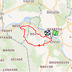
10.3 km | 13.3 km-effort
3h 0min
![](https://static1.geolcdn.com/siteimages/upload/files/16400158638029165_repeat_loop_refresh_sync_direction_icon.png)
Yes
![Walking Walking](https://static1.geolcdn.com/sitytour/trail-icons/101.png)
Vayrac- Puy d'Issolud
Walking
Difficult
Vayrac,
Occitania,
Lot,
France
![](/images/other/stat-length.png)
12.9 km | 17.8 km-effort
4h 1min
![](https://static1.geolcdn.com/siteimages/upload/files/16400158638029165_repeat_loop_refresh_sync_direction_icon.png)
Yes
![Trail Walking Carennac - Magnagues - Photo](https://media.geolcdn.com/t/375/260/99d2ec86-7eb8-4975-a775-ffbced93098f.jpg&format=jpg&maxdim=2)
![Walking Walking](https://static1.geolcdn.com/sitytour/trail-icons/101.png)
2021-11-20_20h14m14_0ePw2rSfp3MfACzh8d3-Xw
Walking
Medium
(1)
Miers,
Occitania,
Lot,
France
![](/images/other/stat-length.png)
9.6 km | 11.9 km-effort
2h 42min
![](https://static1.geolcdn.com/siteimages/upload/files/16400158638029165_repeat_loop_refresh_sync_direction_icon.png)
Yes
![Trail Walking Carennac - Ruines de Taillefer - Photo](https://media.geolcdn.com/t/375/260/33316351-627c-4a04-a0cf-abf1432651da.jpg&format=jpg&maxdim=2)
![Walking Walking](https://static1.geolcdn.com/sitytour/trail-icons/101.png)
Ruines de Taillefer
Walking
Very easy
Carennac,
Occitania,
Lot,
France
![](/images/other/stat-length.png)
6.4 km | 8.2 km-effort
1h 54min
![](https://static1.geolcdn.com/siteimages/upload/files/16400158638029165_repeat_loop_refresh_sync_direction_icon.png)
No
![Trail On foot Vayrac - Mezels - Photo](https://media.geolcdn.com/t/375/260/3e4de3ba-b059-4c9e-b8f7-e172875223cf.jpg&format=jpg&maxdim=2)
![On foot On foot](https://static1.geolcdn.com/sitytour/trail-icons/100.png)
![Trail Walking Loubressac - Laguizayrie - Photo](https://media.geolcdn.com/t/375/260/efa1d10d-bed3-47cb-bc2a-e3221adba559.jpg&format=jpg&maxdim=2)
![Walking Walking](https://static1.geolcdn.com/sitytour/trail-icons/101.png)
![Trail Walking Carennac - ruiné de taillefer - Photo](https://media.geolcdn.com/t/375/260/ext.jpg?maxdim=2&url=https%3A%2F%2Fservices.sitytrail.com%2FGeolivesWS%2FDownloadMedia.ashx%3FTrailID%3D535901%26Media%3Dfix__20160310110940.jpg)
![Walking Walking](https://static1.geolcdn.com/sitytour/trail-icons/101.png)
ruiné de taillefer
Walking
Easy
Carennac,
Occitania,
Lot,
France
![](/images/other/stat-length.png)
10.9 km | 15.2 km-effort
2h 39min
![](https://static1.geolcdn.com/siteimages/upload/files/16400158638029165_repeat_loop_refresh_sync_direction_icon.png)
Yes
![Trail Walking Bilhac - mas del pouch par moulin de la force - Photo](https://media.geolcdn.com/t/375/260/ext.jpg?maxdim=2&url=https%3A%2F%2Fstatic1.geolcdn.com%2Fsiteimages%2Fupload%2Ffiles%2F1553511878bg_sport_marche.png)
![Walking Walking](https://static1.geolcdn.com/sitytour/trail-icons/101.png)
mas del pouch par moulin de la force
Walking
Very easy
(2)
Bilhac,
New Aquitaine,
Corrèze,
France
![](/images/other/stat-length.png)
8.4 km | 10.7 km-effort
2h 18min
![](https://static1.geolcdn.com/siteimages/upload/files/16400158638029165_repeat_loop_refresh_sync_direction_icon.png)
Yes