![](/images/other/stat-length.png)
![Trail Mountain bike Manteyer - VTT05 - Ceuze et Ceuzette - Photo](https://media.geolcdn.com/t/1900/400/ext.pjpeg?maxdim=2&url=https%3A%2F%2Fservices.sitytrail.com%2FGeolivesWS%2FDownloadMedia.ashx%3FTrailID%3D893896%26Media%3Dc8eb80ee-932f-4d00-922f-9784c89716e9.jpg)
VTT05 - Ceuze et Ceuzette
Camping Les Rives du Lac
Les Hautes Alpes à découvrir ! GUIDE+
![Length](/images/other/stat-length.png)
![Max alt](https://static1.geolcdn.com/siteimages/upload/files/1508320355ic_sort_altitude_max_24dp.png)
![Uphill gradient](https://static1.geolcdn.com/siteimages/upload/files/1508320355ic_sort_den_pos_24dp.png)
![Km-Effort](/images/other/stat-length.png)
![Min alt](https://static1.geolcdn.com/siteimages/upload/files/1508320355ic_sort_altitude_min_24dp.png)
![Downhill gradient](https://static1.geolcdn.com/siteimages/upload/files/1508320355ic_sort_den_neg_24dp.png)
![Boucle](https://static1.geolcdn.com/siteimages/upload/files/16400158638029165_repeat_loop_refresh_sync_direction_icon.png)
![Mountain bike](https://static1.geolcdn.com/sitytour/trail-icons/202.png)
3h20
Difficulty : Difficult
![Scan this QR Code to open this trail in the SityTrail application](https://capi.geolives.com/qq0zvz2zws4bq2lad0pu/sitytour/trails/893896/qr.png?size=200)
FREE GPS app for hiking
About
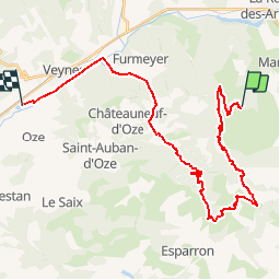
Trail Mountain bike of 33 km to be discovered at Provence-Alpes-Côte d'Azur, Hautes-Alpes, Manteyer. This trail is proposed by Camping Les Rives du Lac.
Description
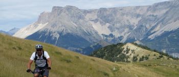
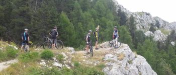
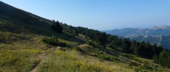
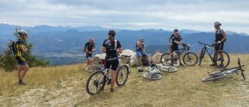
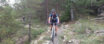
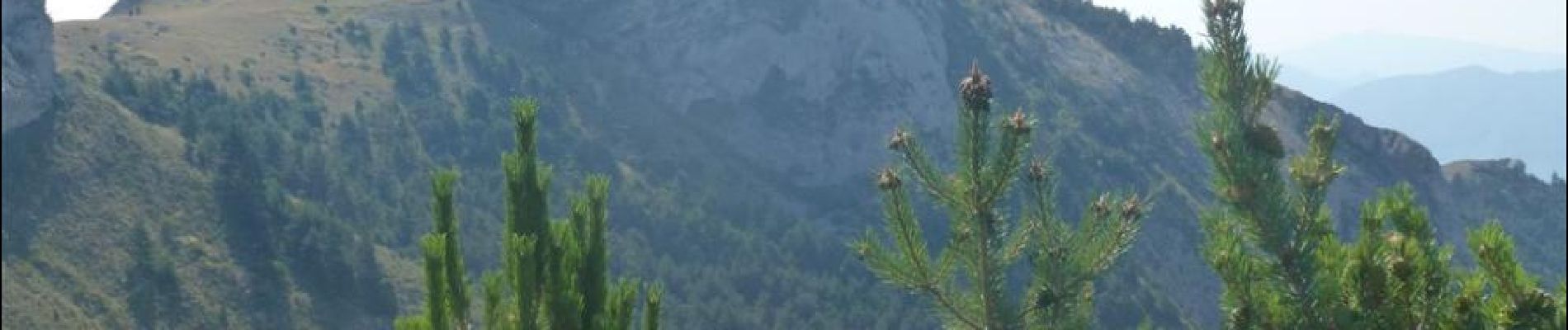
Beautiful hike from the station Céüze and ends in Veynes. Some technical passages but no danger. Little climb compared to many descents. To do absolutely!
Plan a second car at the campsite to go look for the first, or go back on a bike!
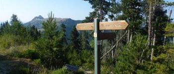
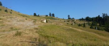
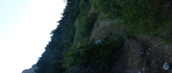
From the station, go up towards La Manche. Technical climb using a single. Do not be discouraged ! Go along the cliff and then continue towards Col des Guérins. From the pass, take the forest trail that climbs to the Petite Céuze, and before the summit, follow the sign MTB on the right. Go down to the Col de Bois Rien, then go along the North side to the Col de la Baume. From there, an obvious descent northwards to the valley floor and the forest track that joins the Drouzet stream. The hike ends on the Col d'Espréaux road.
Points of interest
Positioning
Comments
Trails nearby
![Trail Walking Manteyer - R14 Pic de Ceuze - Photo](https://media.geolcdn.com/t/375/260/ext.jpg?maxdim=2&url=https%3A%2F%2Fservices.sitytrail.com%2FGeolivesWS%2FDownloadMedia.ashx%3FTrailID%3D890870%26Media%3D0ba1b82b-7041-4a22-9f15-1bc2a79485cb.jpg)
![Walking Walking](https://static1.geolcdn.com/sitytour/trail-icons/101.png)
Walking
![](/images/other/stat-length.png)
![](https://static1.geolcdn.com/siteimages/upload/files/16400158638029165_repeat_loop_refresh_sync_direction_icon.png)
![Trail Mountain bike Manteyer - VTT32 aspremont - Photo](https://media.geolcdn.com/t/375/260/ext.jpg?maxdim=2&url=https%3A%2F%2Fservices.sitytrail.com%2FGeolivesWS%2FDownloadMedia.ashx%3FTrailID%3D894053%26Media%3Dff964c78-0895-4177-a23a-bbf5c1f8ef2b.jpg)
![Mountain bike Mountain bike](https://static1.geolcdn.com/sitytour/trail-icons/202.png)
Mountain bike
![](/images/other/stat-length.png)
![](https://static1.geolcdn.com/siteimages/upload/files/16400158638029165_repeat_loop_refresh_sync_direction_icon.png)
![Trail Mountain bike Châteauneuf-d'Oze - ceuse9 avril 2012 - Photo](https://media.geolcdn.com/t/375/260/ext.jpg?maxdim=2&url=https%3A%2F%2Fstatic1.geolcdn.com%2Fsiteimages%2Fupload%2Ffiles%2F1524743154velo.jpg)
![Mountain bike Mountain bike](https://static1.geolcdn.com/sitytour/trail-icons/202.png)
Mountain bike
![](/images/other/stat-length.png)
![](https://static1.geolcdn.com/siteimages/upload/files/16400158638029165_repeat_loop_refresh_sync_direction_icon.png)
![Trail Trail Châteauneuf-d'Oze - Tour et sommet petite Céüse - Photo](https://media.geolcdn.com/t/375/260/35ba00a4-91ec-4796-9ff5-ca90e4bc8831.jpg&format=jpg&maxdim=2)
![Trail Trail](https://static1.geolcdn.com/sitytour/trail-icons/104.png)
Trail
![](/images/other/stat-length.png)
![](https://static1.geolcdn.com/siteimages/upload/files/16400158638029165_repeat_loop_refresh_sync_direction_icon.png)
![Trail Walking Sigoyer - corniche de Ceüze tour - Photo](https://media.geolcdn.com/t/375/260/606b8b0a-ef0b-4016-a35b-711cbf3016a8.jpg&format=jpg&maxdim=2)
![Walking Walking](https://static1.geolcdn.com/sitytour/trail-icons/101.png)
Walking
![](/images/other/stat-length.png)
![](https://static1.geolcdn.com/siteimages/upload/files/16400158638029165_repeat_loop_refresh_sync_direction_icon.png)
![Trail Walking Manteyer - Tour de Ceüze - Photo](https://media.geolcdn.com/t/375/260/111429d2-6166-4501-9497-b5a5a3a83e3c.jpg&format=jpg&maxdim=2)
![Walking Walking](https://static1.geolcdn.com/sitytour/trail-icons/101.png)
Walking
![](/images/other/stat-length.png)
![](https://static1.geolcdn.com/siteimages/upload/files/16400158638029165_repeat_loop_refresh_sync_direction_icon.png)
![Trail Walking Sigoyer - Petite Ceüze - Photo](https://media.geolcdn.com/t/375/260/a4aca269-bd26-4bc0-bc52-b9c9a64b1557.jpg&format=jpg&maxdim=2)
![Walking Walking](https://static1.geolcdn.com/sitytour/trail-icons/101.png)
Walking
![](/images/other/stat-length.png)
![](https://static1.geolcdn.com/siteimages/upload/files/16400158638029165_repeat_loop_refresh_sync_direction_icon.png)
![Trail Mountain bike La Roche-des-Arnauds - La Rivière - Photo](https://media.geolcdn.com/t/375/260/0a9ee634-fce3-4af5-9c6a-1f11e946fd54.jpg&format=jpg&maxdim=2)
![Mountain bike Mountain bike](https://static1.geolcdn.com/sitytour/trail-icons/202.png)
Mountain bike
![](/images/other/stat-length.png)
![](https://static1.geolcdn.com/siteimages/upload/files/16400158638029165_repeat_loop_refresh_sync_direction_icon.png)
![Trail Walking Manteyer - Pic de Céüze - Photo](https://media.geolcdn.com/t/375/260/d5d2a7aa-e169-4533-bb0a-a9909c91e710.jpg&format=jpg&maxdim=2)
![Walking Walking](https://static1.geolcdn.com/sitytour/trail-icons/101.png)
Walking
![](/images/other/stat-length.png)
![](https://static1.geolcdn.com/siteimages/upload/files/16400158638029165_repeat_loop_refresh_sync_direction_icon.png)