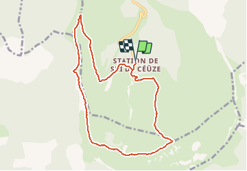
![](/images/other/stat-length.png)
![Trail Walking Manteyer - R14 Pic de Ceuze - Photo](https://media.geolcdn.com/t/1900/400/ext.pjpeg?maxdim=2&url=https%3A%2F%2Fservices.sitytrail.com%2FGeolivesWS%2FDownloadMedia.ashx%3FTrailID%3D890870%26Media%3D0ba1b82b-7041-4a22-9f15-1bc2a79485cb.jpg)
R14 Pic de Ceuze
Camping Les Rives du Lac
Les Hautes Alpes à découvrir ! GUIDE+
![Length](/images/other/stat-length.png)
![Max alt](https://static1.geolcdn.com/siteimages/upload/files/1508320355ic_sort_altitude_max_24dp.png)
![Uphill gradient](https://static1.geolcdn.com/siteimages/upload/files/1508320355ic_sort_den_pos_24dp.png)
![Km-Effort](/images/other/stat-length.png)
![Min alt](https://static1.geolcdn.com/siteimages/upload/files/1508320355ic_sort_altitude_min_24dp.png)
![Downhill gradient](https://static1.geolcdn.com/siteimages/upload/files/1508320355ic_sort_den_neg_24dp.png)
![Boucle](https://static1.geolcdn.com/siteimages/upload/files/16400158638029165_repeat_loop_refresh_sync_direction_icon.png)
![Walking](https://static1.geolcdn.com/sitytour/trail-icons/101.png)
4h30
Difficulty : Medium
![Scan this QR Code to open this trail in the SityTrail application](https://capi.geolives.com/qq0zvz2zws4bq2lad0pu/sitytour/trails/890870/qr.png?size=200)
FREE GPS app for hiking
About
Trail Walking of 9.6 km to be discovered at Provence-Alpes-Côte d'Azur, Hautes-Alpes, Manteyer. This trail is proposed by Camping Les Rives du Lac.
Description
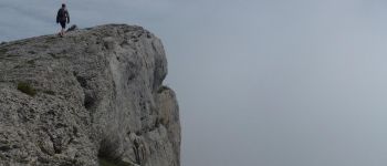
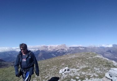
The cliff of Céüse offers one of the most beautiful views of the Alps. Begin the hike by heading west so that the sun does not dazzle you. You can admire the Vercors, then Mont Ventoux, Durance, Ubaye, Italy and Queyras, the Ecrins and the Pic de Bure! This hike is long but only the start is a bit steep. Then it's mostly a long walk on the flat. It can be shortened once on the big plateau, without going to Pic de Céüze. After the passage to "La Manche", you will arrive on a small plateau where there are very often marmots
Points of interest
Positioning
Comments
Trails nearby
![Trail Mountain bike Manteyer - VTT32 aspremont - Photo](https://media.geolcdn.com/t/375/260/ext.jpg?maxdim=2&url=https%3A%2F%2Fservices.sitytrail.com%2FGeolivesWS%2FDownloadMedia.ashx%3FTrailID%3D894053%26Media%3Dff964c78-0895-4177-a23a-bbf5c1f8ef2b.jpg)
![Mountain bike Mountain bike](https://static1.geolcdn.com/sitytour/trail-icons/202.png)
Mountain bike
![](/images/other/stat-length.png)
![](https://static1.geolcdn.com/siteimages/upload/files/16400158638029165_repeat_loop_refresh_sync_direction_icon.png)
![Trail Mountain bike Châteauneuf-d'Oze - ceuse9 avril 2012 - Photo](https://media.geolcdn.com/t/375/260/ext.jpg?maxdim=2&url=https%3A%2F%2Fstatic1.geolcdn.com%2Fsiteimages%2Fupload%2Ffiles%2F1524743154velo.jpg)
![Mountain bike Mountain bike](https://static1.geolcdn.com/sitytour/trail-icons/202.png)
Mountain bike
![](/images/other/stat-length.png)
![](https://static1.geolcdn.com/siteimages/upload/files/16400158638029165_repeat_loop_refresh_sync_direction_icon.png)
![Trail Trail Châteauneuf-d'Oze - Tour et sommet petite Céüse - Photo](https://media.geolcdn.com/t/375/260/35ba00a4-91ec-4796-9ff5-ca90e4bc8831.jpg&format=jpg&maxdim=2)
![Trail Trail](https://static1.geolcdn.com/sitytour/trail-icons/104.png)
Trail
![](/images/other/stat-length.png)
![](https://static1.geolcdn.com/siteimages/upload/files/16400158638029165_repeat_loop_refresh_sync_direction_icon.png)
![Trail Walking Sigoyer - corniche de Ceüze tour - Photo](https://media.geolcdn.com/t/375/260/606b8b0a-ef0b-4016-a35b-711cbf3016a8.jpg&format=jpg&maxdim=2)
![Walking Walking](https://static1.geolcdn.com/sitytour/trail-icons/101.png)
Walking
![](/images/other/stat-length.png)
![](https://static1.geolcdn.com/siteimages/upload/files/16400158638029165_repeat_loop_refresh_sync_direction_icon.png)
![Trail Walking Manteyer - Tour de Ceüze - Photo](https://media.geolcdn.com/t/375/260/111429d2-6166-4501-9497-b5a5a3a83e3c.jpg&format=jpg&maxdim=2)
![Walking Walking](https://static1.geolcdn.com/sitytour/trail-icons/101.png)
Walking
![](/images/other/stat-length.png)
![](https://static1.geolcdn.com/siteimages/upload/files/16400158638029165_repeat_loop_refresh_sync_direction_icon.png)
![Trail Walking Sigoyer - Petite Ceüze - Photo](https://media.geolcdn.com/t/375/260/a4aca269-bd26-4bc0-bc52-b9c9a64b1557.jpg&format=jpg&maxdim=2)
![Walking Walking](https://static1.geolcdn.com/sitytour/trail-icons/101.png)
Walking
![](/images/other/stat-length.png)
![](https://static1.geolcdn.com/siteimages/upload/files/16400158638029165_repeat_loop_refresh_sync_direction_icon.png)
![Trail Mountain bike La Roche-des-Arnauds - La Rivière - Photo](https://media.geolcdn.com/t/375/260/0a9ee634-fce3-4af5-9c6a-1f11e946fd54.jpg&format=jpg&maxdim=2)
![Mountain bike Mountain bike](https://static1.geolcdn.com/sitytour/trail-icons/202.png)
Mountain bike
![](/images/other/stat-length.png)
![](https://static1.geolcdn.com/siteimages/upload/files/16400158638029165_repeat_loop_refresh_sync_direction_icon.png)
![Trail Walking Manteyer - Pic de Céüze - Photo](https://media.geolcdn.com/t/375/260/d5d2a7aa-e169-4533-bb0a-a9909c91e710.jpg&format=jpg&maxdim=2)
![Walking Walking](https://static1.geolcdn.com/sitytour/trail-icons/101.png)
Walking
![](/images/other/stat-length.png)
![](https://static1.geolcdn.com/siteimages/upload/files/16400158638029165_repeat_loop_refresh_sync_direction_icon.png)
![Trail Running Manteyer - Trail 09 - Céüze par le Pas du Loup - Photo](https://media.geolcdn.com/t/375/260/1ece446d-3329-4f69-b498-9f27aef494d2.jpg&format=jpg&maxdim=2)
![Running Running](https://static1.geolcdn.com/sitytour/trail-icons/103.png)
Running
![](/images/other/stat-length.png)
![](https://static1.geolcdn.com/siteimages/upload/files/16400158638029165_repeat_loop_refresh_sync_direction_icon.png)
Rando plus que splendide, des panoramas à couper le souffle
Awesome trail with the most beautiful views you can dream of!
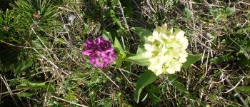
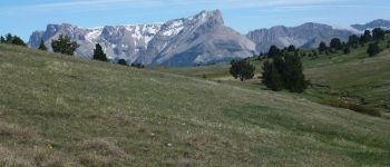
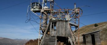
Probably the most beautiful walk I have done in this region so far! Nice changes between lush grassland with wild raspberries and flowers in the high plains and stunning 360 views over Dévoluy, Ecrins and Baronnies from the cliffs. Mostly pretty flat and easy to walk with some steeper climb/descent at the start/end. The starting point is a bit difficult to find: Park your car one turn below the skiing station, enter forest track a little above (briefly ignoring the complaints of your GPS), find the skiing lift track (back on the GPS trail) and follow it almost all the way up. At the end, the GPS trail will lead you cross-country down a long grass slope, a bit steeper and more demanding in some parts. Can probably be avoided by crossing over to the other side of the valley at the top of the ski lift and following the narrow track down to the skiing station. Enjoy!