Trail Walking Saint-Apollinaire - les circuits des oucanes - Photo
© OpenStreetMap contributors
Length
Length
12.5 km
Max alt
Max alt
2321 m
Uphill gradient
Uphill gradient
725 m
Km-Effort
Km-Effort  
23 km
Min alt
Min alt
1416 m
Downhill gradient
Downhill gradient
990 m
Boucle
Boucle
No
Creation date :
2018-04-16 20:46:30.283
Updated on :
2018-04-16 20:46:30.283

(0 Reviews)

Walking
Walking
7h27
Difficulty : Medium

Scan this QR Code to open this trail in the SityTrail application

FREE GPS app for hiking

Logo SityTrail SityTrail

IGN / Geographical institutes

Download SityTrail from the App Store Download SityTrail from Google Play

Logo SityTrail SityTrail World

The world is yours!

Download SityTrail from the App Store Download SityTrail from Google Play Download SityTrail on Huawei AppGallery

About

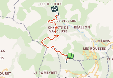
Trail Walking of 12.5 km to be discovered at Provence-Alpes-Côte d'Azur, Hautes-Alpes, Saint-Apollinaire. This trail is proposed by anonymous_0a50d3ca6f.

Description

Avec bivouac cabane forestière Joubelle

Elevation profile

Positioning

Country:
France
Region :
Provence-Alpes-Côte d'Azur
Department/Province :
Hautes-Alpes
Municipality :
Saint-Apollinaire
Location:
Unknown
Start:(UTM)
289330 ; 4938357 (32T) N.

Trails nearby

Trail Walking Réallon - AIguilles de Chabrieres au départ de la Station de ski Reallon - Photo
Walking
Maca8284

Walking

Very difficult
(1)
Réallon, Provence-Alpes-Côte d'Azur, Hautes-Alpes, France
14 km | 25 km-effort
6h 0min
Yes
Trail Walking Réallon - Aiguilles de Chabrière - Photo
Walking
GUIDE
David25400

Walking

Easy
(1)
Réallon, Provence-Alpes-Côte d'Azur, Hautes-Alpes, France
12.2 km | 23 km-effort
5h 35min
Yes
Trail Walking Réallon - le fort de Réallon - Photo
Walking
gildascb

Walking

Very easy
(1)
Réallon, Provence-Alpes-Côte d'Azur, Hautes-Alpes, France
8 km | 11.8 km-effort
2h 11min
Yes
Trail Walking Réallon - SityTrail - 2556786 - aiguilles-de-chabriere - Photo
Walking
GUIDE
amiral13

Walking

Difficult
Réallon, Provence-Alpes-Côte d'Azur, Hautes-Alpes, France
11.8 km | 23 km-effort
6h 0min
Yes
Trail Snowshoes Réallon - Raquettes Réallon  - Photo
Snowshoes
GUIDE
David25400

Snowshoes

Easy
Réallon, Provence-Alpes-Côte d'Azur, Hautes-Alpes, France
6.5 km | 14.3 km-effort
3h 27min
Yes
Trail Walking Réallon - Reallon-Serre du Mouton 7km - Photo
Walking
GUIDE
thonyc

Walking

Easy
Réallon, Provence-Alpes-Côte d'Azur, Hautes-Alpes, France
7.3 km | 13 km-effort
2h 53min
Yes
Trail Walking Saint-Apollinaire - Aiguilles Chabrieres 08/08/18 - Photo
Walking
GUIDE
R@ph

Walking

Medium
Saint-Apollinaire, Provence-Alpes-Côte d'Azur, Hautes-Alpes, France
11 km | 24 km-effort
4h 42min
Yes
Trail Mountain bike Savines-le-Lac - circuit de serre verger N°25 - Photo
Mountain bike
guariso

Mountain bike

Medium
(1)
Savines-le-Lac, Provence-Alpes-Côte d'Azur, Hautes-Alpes, France
9.8 km | 15.8 km-effort
1h 30min
No
Trail Walking Réallon - Embrunais - Réallon Le Fort - 3.2km 200m 1h10 - 2018 06 28 - public - Photo
Walking
GUIDE
Orcal37

Walking

Very easy
Réallon, Provence-Alpes-Côte d'Azur, Hautes-Alpes, France
3.1 km | 5.7 km-effort
1h 20min
Yes


Close
My subscriptions