Trail Other activity Ceillac - Ceillac par col fromage puis bramousse descente par la combe - Photo

Ceillac par col fromage puis bramousse descente par la combe

© OpenStreetMap contributors
Length
Length
13.4 km
Max alt
Max alt
2559 m
Uphill gradient
Uphill gradient
927 m
Km-Effort
Km-Effort  
26 km
Min alt
Min alt
1644 m
Downhill gradient
Downhill gradient
927 m
Boucle
Boucle
Yes
Creation date :
2017-07-05 00:00:00.0
Updated on :
2021-07-21 13:55:42.893

(0 Reviews)

Other activity
Other activity
6h24
Difficulty : Difficult

Scan this QR Code to open this trail in the SityTrail application

FREE GPS app for hiking

Logo SityTrail SityTrail

IGN / Geographical institutes

Download SityTrail from the App Store Download SityTrail from Google Play

Logo SityTrail SityTrail World

The world is yours!

Download SityTrail from the App Store Download SityTrail from Google Play Download SityTrail on Huawei AppGallery

About

Trail Other activity of 13.4 km to be discovered at Provence-Alpes-Côte d'Azur, Hautes-Alpes, Ceillac. This trail is proposed by JosephRigolet.

Description

Difficile à refaire par village villard sans passer par la combe chemin à l envers par bramousse d abord

Elevation profile

Photos

31 photos in total. Please click on a photo to see them all in the gallery.

Positioning

Country:
France
Region :
Provence-Alpes-Côte d'Azur
Department/Province :
Hautes-Alpes
Municipality :
Ceillac
Location:
Unknown
Start:(UTM)
323900 ; 4948357 (32T) N.

Trails nearby

Trail Walking Ceillac - Crêtes de Chambrettes - Photo
Walking
GUIDE
amiral13

Walking

Medium
(1)
Ceillac, Provence-Alpes-Côte d'Azur, Hautes-Alpes, France
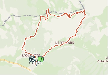
13.4 km | 26 km-effort
5h 53min
Yes
Trail Walking Ceillac - 05 Tour Font Sancte - étape 1 - Photo
Walking
Maryma

Walking

Very difficult
(1)
Ceillac, Provence-Alpes-Côte d'Azur, Hautes-Alpes, France
16.5 km | 36 km-effort
8h 9min
No
Trail Walking Vars - 05 Tour Font Sancte - étape 2 - Photo
Walking
Maryma

Walking

Very difficult
(1)
Vars, Provence-Alpes-Côte d'Azur, Hautes-Alpes, France
19 km | 38 km-effort
8h 41min
No
Trail Walking Ceillac - Col Girardin - Photo
Walking
GUIDE
Marco05

Walking

Very difficult
Ceillac, Provence-Alpes-Côte d'Azur, Hautes-Alpes, France
14.5 km | 29 km-effort
6h 32min
Yes
Trail Walking Ceillac - Ceillac - St Véran - Photo
Walking
GUIDE
romanceline

Walking

Medium
Ceillac, Provence-Alpes-Côte d'Azur, Hautes-Alpes, France
13.5 km | 28 km-effort
7h 22min
No
Trail Other activity Ceillac - Col de la petite Par. Col Girardin  - Photo
Other activity
GUIDE
nadd73

Other activity

Difficult
Ceillac, Provence-Alpes-Côte d'Azur, Hautes-Alpes, France
13.9 km | 32 km-effort
7h 36min
Yes
Trail Walking Ceillac - la pointe de la Saume (traversée) - Photo
Walking
GUIDE
amiral13

Walking

Difficult
Ceillac, Provence-Alpes-Côte d'Azur, Hautes-Alpes, France
15 km | 34 km-effort
6h 43min
No
Trail Walking Ceillac - Lac Ste Anne et Tête de Girardin - Photo
Walking
GUIDE
amiral13

Walking

Medium
Ceillac, Provence-Alpes-Côte d'Azur, Hautes-Alpes, France
14.4 km | 27 km-effort
5h 48min
Yes
Trail Walking Ceillac - lac Sainte Anne - Photo
Walking
griffet

Walking

Easy
(2)
Ceillac, Provence-Alpes-Côte d'Azur, Hautes-Alpes, France
10.7 km | 17.9 km-effort
5h 16min
No


Close
My subscriptions