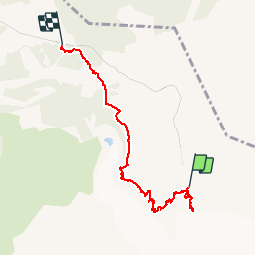
Trail Walking Saint-Gervais-les-Bains - Du Nid d'Aigle à Bellevue  - Photo
© OpenStreetMap contributors
Length
Length
5.8 km
Max alt
Max alt
2428 m
Uphill gradient
Uphill gradient
96 m
Km-Effort
Km-Effort  
9.2 km
Min alt
Min alt
1747 m
Downhill gradient
Downhill gradient
723 m
Boucle
Boucle
No
Creation date :
2016-09-12 00:00:00.0
Updated on :
2016-09-12 00:00:00.0

(0 Reviews)

Walking
Walking
2h50
Difficulty : Easy

Scan this QR Code to open this trail in the SityTrail application

FREE GPS app for hiking

Logo SityTrail SityTrail

IGN / Geographical institutes

Download SityTrail from the App Store Download SityTrail from Google Play

Logo SityTrail SityTrail World

The world is yours!

Download SityTrail from the App Store Download SityTrail from Google Play Download SityTrail on Huawei AppGallery

About

Trail Walking of 5.8 km to be discovered at Auvergne-Rhône-Alpes, Upper Savoy, Saint-Gervais-les-Bains. This trail is proposed by patpounet73.

Description

Les temps, distances, dénivelés prennent en compte l'aller-retour au belvédère et la descente à la gare de Bellevue.
Du refuge du Nid d'Aigle au belvédère du glacier, compter 30 mn aller-retour.
Du refuge à l'arrêt de Bellevue, prévoir 2h15 en tenant compte de quelques arrêts pour admirer le paysage. Être bien chaussé est impératif.
Pour info, l'arrêt du tramway à Bellevue est bien celui à proximité de La Chalette.

Elevation profile

Points of interest

Point of interest Saint-Gervais-les-Bains - Belvédère glacier de Bionnassay - Photo
patpounet73
SAINT-GERVAIS-LES-BAINS 

Positioning

Country:
France
Region :
Auvergne-Rhône-Alpes
Department/Province :
Upper Savoy
Municipality :
Saint-Gervais-les-Bains
Location:
Unknown
Start:(UTM)
329169 ; 5080399 (32T) N.

Trails nearby

Trail Walking Les Houches - 2024-05-29_17h11m02_christ-roi - Photo
Walking
GUIDE
mumu.larandonneuse

Walking

Easy
(1)
Les Houches, Auvergne-Rhône-Alpes, Upper Savoy, France
1.8 km | 4.2 km-effort
56min
No
Trail Walking Chamonix-Mont-Blanc - Glacier des Bossons Les Houches Chamonix - Photo
Walking
tracegps

Walking

Difficult
(2)
Chamonix-Mont-Blanc, Auvergne-Rhône-Alpes, Upper Savoy, France
13.1 km | 28 km-effort
5h 0min
Yes
Trail Touring skiing Les Contamines-Montjoie - Le Monthieu  - Photo
Touring skiing
GUIDE
nadd73

Touring skiing

Easy
Les Contamines-Montjoie, Auvergne-Rhône-Alpes, Upper Savoy, France
8.2 km | 21 km-effort
4h 25min
Yes
Trail Touring skiing Les Contamines-Montjoie - Couloir de la chèvre  - Photo
Touring skiing
GUIDE
nadd73

Touring skiing

Difficult
Les Contamines-Montjoie, Auvergne-Rhône-Alpes, Upper Savoy, France
19 km | 43 km-effort
7h 43min
Yes
Trail Walking Chamonix-Mont-Blanc - Chalet des Pyramides 1895m 11.7.22 - Photo
Walking
GUIDE
fredetpascale

Walking

Medium
Chamonix-Mont-Blanc, Auvergne-Rhône-Alpes, Upper Savoy, France
7.7 km | 15.2 km-effort
3h 30min
Yes
Trail Walking Les Houches - Chalets de Charlousse - Photo
Walking
YannPro81

Walking

Easy
(2)
Les Houches, Auvergne-Rhône-Alpes, Upper Savoy, France
9.2 km | 14.1 km-effort
2h 28min
Yes
Trail Walking Saint-Gervais-les-Bains - Descente au Glacier de Bionnassay depuis le Nid d''Aigle - Photo
Walking
GUIDE
pscheven

Walking

Very easy
(1)
Saint-Gervais-les-Bains, Auvergne-Rhône-Alpes, Upper Savoy, France
839 m | 1.9 km-effort
28min
No
Trail Walking Chamonix-Mont-Blanc - La Jonction depuis le parking de Mont (Chamonix) - Photo
Walking
ScarniereLaurent

Walking

Difficult
Chamonix-Mont-Blanc, Auvergne-Rhône-Alpes, Upper Savoy, France
11.3 km | 28 km-effort
5h 1min
Yes
Trail Walking Les Houches - Maison Neuve (Les Houches) boucle par Bellevue et Mont  Lachat - Photo
Walking
ScarniereLaurent

Walking

Difficult
Les Houches, Auvergne-Rhône-Alpes, Upper Savoy, France
13.6 km | 27 km-effort
4h 0min
Yes


Close
My subscriptions