Trail Walking Saint-Gervais-les-Bains - J8 - Grand Balcon Nord : Prarion - Bellevue - Photo

J8 - Grand Balcon Nord : Prarion - Bellevue

© OpenStreetMap contributors
Length
Length
3.5 km
Max alt
Max alt
1857 m
Uphill gradient
Uphill gradient
158 m
Km-Effort
Km-Effort  
5.8 km
Min alt
Min alt
1657 m
Downhill gradient
Downhill gradient
204 m
Boucle
Boucle
No
Creation date :
2024-09-08 08:31:21.685
Updated on :
2024-10-01 17:06:06.761

(0 Reviews)

Walking
Walking
1h23
Difficulty : Medium

Scan this QR Code to open this trail in the SityTrail application

FREE GPS app for hiking

Logo SityTrail SityTrail

IGN / Geographical institutes

Download SityTrail from the App Store Download SityTrail from Google Play

Logo SityTrail SityTrail World

The world is yours!

Download SityTrail from the App Store Download SityTrail from Google Play Download SityTrail on Huawei AppGallery

About

Trail Walking of 3.5 km to be discovered at Auvergne-Rhône-Alpes, Upper Savoy, Saint-Gervais-les-Bains. This trail is proposed by Je vous emmène sur mes chemins .

Description

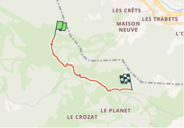
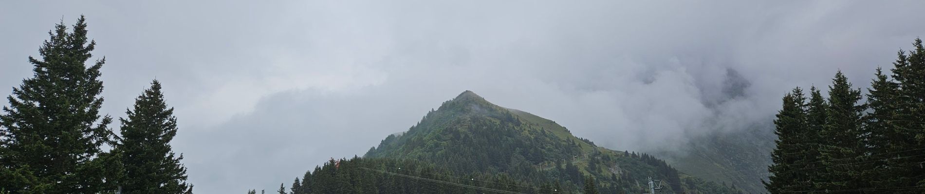
J8 - R5 - Grand Balcon Nord : Prarion - Bellevue

Randonnée située sur le flanc nord de la vallée, en moyenne-montagne. Les points de départ et d’arrivée sont desservis par des remontées mécaniques.

Montée par le télécabine du Prarion.

- l’Hôtel du Prarion et la gare de télécabine LHSG (1 853 m).
- les alpages
- le Col de Voza (1 653 m).
- la voie ferrée du Tramway du Mont-Blanc vers Bellevue.

Descente avec le téléphérique de Bellevue

Elevation profile

Photos

Positioning

Country:
France
Region :
Auvergne-Rhône-Alpes
Department/Province :
Upper Savoy
Municipality :
Saint-Gervais-les-Bains
Location:
Unknown
Start:(UTM)
325648 ; 5083837 (32T) N.

Trails nearby

Trail Walking Les Houches - J4 - Les Chavants - Charousse - Vaudagne  - Photo
Walking

Walking

Medium
(1)
Les Houches, Auvergne-Rhône-Alpes, Upper Savoy, France
7.3 km | 11.4 km-effort
2h 10min
Yes
Trail Walking Les Houches - 2024-05-29_17h11m02_christ-roi - Photo
Walking
GUIDE
mumu.larandonneuse

Walking

Easy
(1)
Les Houches, Auvergne-Rhône-Alpes, Upper Savoy, France
1.8 km | 4.2 km-effort
56min
No
Trail Walking Saint-Gervais-les-Bains - M_VEROCE 74190 Pavillon du Joly - Photo
Walking
ANDREJAC

Walking

Medium
(1)
Saint-Gervais-les-Bains, Auvergne-Rhône-Alpes, Upper Savoy, France
5.9 km | 10.7 km-effort
2h 25min
Yes
Trail Running Passy - grimpe de chedde ayeres - Photo
Running
winbat11

Running

Very easy
(1)
Passy, Auvergne-Rhône-Alpes, Upper Savoy, France
15 km | 28 km-effort
2h 46min
No
Trail Walking Les Houches - Chalets de Charlousse - Photo
Walking
YannPro81

Walking

Easy
(2)
Les Houches, Auvergne-Rhône-Alpes, Upper Savoy, France
9.2 km | 14.1 km-effort
2h 28min
Yes
Trail Walking Saint-Gervais-les-Bains - Descente au Glacier de Bionnassay depuis le Nid d''Aigle - Photo
Walking
GUIDE
pscheven

Walking

Very easy
(1)
Saint-Gervais-les-Bains, Auvergne-Rhône-Alpes, Upper Savoy, France
839 m | 1.9 km-effort
28min
No
Trail Walking Les Houches - J21 - R20 - La Fontaine - La Tour St Michel - Photo
Walking

Walking

Medium
Les Houches, Auvergne-Rhône-Alpes, Upper Savoy, France
5 km | 6.3 km-effort
1h 22min
Yes
Trail Walking Saint-Gervais-les-Bains - J17 - R16 - Le Plan de la Croix - Bettex - Photo
Walking

Walking

Easy
Saint-Gervais-les-Bains, Auvergne-Rhône-Alpes, Upper Savoy, France
5.8 km | 7.9 km-effort
1h 35min
No
Trail Walking Saint-Gervais-les-Bains - J15 - R14 - Bellevue - Col de Voza - Bionnassay - Le Planet - L'Are - Photo
Walking

Walking

Difficult
Saint-Gervais-les-Bains, Auvergne-Rhône-Alpes, Upper Savoy, France
8.2 km | 14.5 km-effort
2h 32min
Yes


Close
My subscriptions