![](/images/other/stat-length.png)
![Trail Walking Toulon - faron est ouest solo - Photo](https://media.geolcdn.com/t/1900/400/67426455-edd0-40ee-9385-b2968faa53e3.jpg&format=pjpeg&maxdim=2)
faron est ouest solo
cdanielrando
User
![Length](/images/other/stat-length.png)
![Max alt](https://static1.geolcdn.com/siteimages/upload/files/1508320355ic_sort_altitude_max_24dp.png)
![Uphill gradient](https://static1.geolcdn.com/siteimages/upload/files/1508320355ic_sort_den_pos_24dp.png)
![Km-Effort](/images/other/stat-length.png)
![Min alt](https://static1.geolcdn.com/siteimages/upload/files/1508320355ic_sort_altitude_min_24dp.png)
![Downhill gradient](https://static1.geolcdn.com/siteimages/upload/files/1508320355ic_sort_den_neg_24dp.png)
![Boucle](https://static1.geolcdn.com/siteimages/upload/files/16400158638029165_repeat_loop_refresh_sync_direction_icon.png)
![Walking](https://static1.geolcdn.com/sitytour/trail-icons/101.png)
4h17
Difficulty : Difficult
![Scan this QR Code to open this trail in the SityTrail application](https://capi.geolives.com/qq0zvz2zws4bq2lad0pu/sitytour/trails/3437323/qr.png?size=200)
FREE GPS app for hiking
About
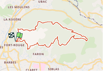
Trail Walking of 11.7 km to be discovered at Provence-Alpes-Côte d'Azur, Var, Toulon. This trail is proposed by cdanielrando.
Description
Belle randonnée qui fait découvrir le Mt Faron par les crêtes d'Ouest en Est en passant par la tr de l'Ubac, le mémorial, le zoo, le sommet , le fort de la croix Faron, la maison forestière Emile Vincent. Deux difficultés dont une très physique : la montée aux antennes depuis la tr de l'ubac par le sentier bien balisé en bleu: puis, de la citerne à l'Ouest du fort de la croix Faron au km 7 bien suivre la trace hors sentier mais assez dégagée. Pk fort St Antoine
Positioning
Comments
Trails nearby
![Trail Walking Ollioules - SityTrail - 1041295 - le-destel-grotte-des-joncs - Photo](https://media.geolcdn.com/t/375/260/b00c002a-3425-4f84-ae24-7620ef9e7315.jpg&format=jpg&maxdim=2)
![Walking Walking](https://static1.geolcdn.com/sitytour/trail-icons/101.png)
Walking
![](/images/other/stat-length.png)
![](https://static1.geolcdn.com/siteimages/upload/files/16400158638029165_repeat_loop_refresh_sync_direction_icon.png)
![Trail Walking Le Revest-les-Eaux - Boucle: La ripelle - Source de la ripelle - Le Chateau de Tourris - Les grottes de sable - La carrière aux fourmis - Les puits renovés de M. Lambicchi - Les ruines des Olivières - La ferme de la Touravelle - à Le Revest-les-Eaux - Photo](https://media.geolcdn.com/t/375/260/0dbff04b-2a84-4eed-a6e8-7a56bc074382.jpg&format=jpg&maxdim=2)
![Walking Walking](https://static1.geolcdn.com/sitytour/trail-icons/101.png)
Walking
![](/images/other/stat-length.png)
![](https://static1.geolcdn.com/siteimages/upload/files/16400158638029165_repeat_loop_refresh_sync_direction_icon.png)
![Trail Walking Toulon - Faron versant Nord - Photo](https://media.geolcdn.com/t/375/260/40a1f88d-10a7-4595-84a1-0086eecb7f84.jpg&format=jpg&maxdim=2)
![Walking Walking](https://static1.geolcdn.com/sitytour/trail-icons/101.png)
Walking
![](/images/other/stat-length.png)
![](https://static1.geolcdn.com/siteimages/upload/files/16400158638029165_repeat_loop_refresh_sync_direction_icon.png)
![Trail Walking Toulon - Faron côté nord - Photo](https://media.geolcdn.com/t/375/260/1a97f987-c174-4fc8-a435-d00586c57288.jpg&format=jpg&maxdim=2)
![Walking Walking](https://static1.geolcdn.com/sitytour/trail-icons/101.png)
Walking
![](/images/other/stat-length.png)
![](https://static1.geolcdn.com/siteimages/upload/files/16400158638029165_repeat_loop_refresh_sync_direction_icon.png)
![Trail Walking Le Revest-les-Eaux - 83 barrage revest les eaux 24-05-2021 - Photo](https://media.geolcdn.com/t/375/260/1106c6f7-fedf-4077-96a1-b48580038b53.jpg&format=jpg&maxdim=2)
![Walking Walking](https://static1.geolcdn.com/sitytour/trail-icons/101.png)
Walking
![](/images/other/stat-length.png)
![](https://static1.geolcdn.com/siteimages/upload/files/16400158638029165_repeat_loop_refresh_sync_direction_icon.png)
![Trail Walking Toulon - Tour Du Baou par falaises - Photo](https://media.geolcdn.com/t/375/260/ext.jpg?maxdim=2&url=https%3A%2F%2Fservices.sitytrail.com%2FGeolivesWS%2FDownloadMedia.ashx%3FTrailID%3D166161%26Media%3D20121215151840.jpeg)
![Walking Walking](https://static1.geolcdn.com/sitytour/trail-icons/101.png)
Walking
![](/images/other/stat-length.png)
![](https://static1.geolcdn.com/siteimages/upload/files/16400158638029165_repeat_loop_refresh_sync_direction_icon.png)
![Trail Walking Évenos - Le broussan croupatier fin randonnée - Photo](https://media.geolcdn.com/t/375/260/ec3fd25e-452d-47c7-8bcf-accd29bcb68e.jpg&format=jpg&maxdim=2)
![Walking Walking](https://static1.geolcdn.com/sitytour/trail-icons/101.png)
Walking
![](/images/other/stat-length.png)
![](https://static1.geolcdn.com/siteimages/upload/files/16400158638029165_repeat_loop_refresh_sync_direction_icon.png)
![Trail Walking Le Revest-les-Eaux - Boucle: Ripelle - Touravelle - Ruines des olivieres - Carrière aux fourmis - Grottes de sables - Vieille valette - Tourris - Source - Ripelle - Photo](https://media.geolcdn.com/t/375/260/ext.jpg?maxdim=2&url=https%3A%2F%2Fstatic1.geolcdn.com%2Fsiteimages%2Fupload%2Ffiles%2F1553511878bg_sport_marche.png)
![Walking Walking](https://static1.geolcdn.com/sitytour/trail-icons/101.png)
Walking
![](/images/other/stat-length.png)
![](https://static1.geolcdn.com/siteimages/upload/files/16400158638029165_repeat_loop_refresh_sync_direction_icon.png)
![Trail Walking La Valette-du-Var - SityTrail - Le Revest - Tourris - Confinement 04 2021 - Photo](https://media.geolcdn.com/t/375/260/79fe425d-11d9-4d0f-acb5-646a4a616c9e.jpg&format=jpg&maxdim=2)
![Walking Walking](https://static1.geolcdn.com/sitytour/trail-icons/101.png)
Walking
![](/images/other/stat-length.png)
![](https://static1.geolcdn.com/siteimages/upload/files/16400158638029165_repeat_loop_refresh_sync_direction_icon.png)