![](/images/other/stat-length.png)
![Trail Walking Ceillac - col de clausis - Photo](https://media.geolcdn.com/t/1900/400/ext.pjpeg?maxdim=2&url=https%3A%2F%2Fstatic1.geolcdn.com%2Fsiteimages%2Fupload%2Ffiles%2F1553511878bg_sport_marche.png)
col de clausis
stelh
User
![Length](/images/other/stat-length.png)
Length
9.4 km
![Max alt](https://static1.geolcdn.com/siteimages/upload/files/1508320355ic_sort_altitude_max_24dp.png)
Max alt
2763 m
![Uphill gradient](https://static1.geolcdn.com/siteimages/upload/files/1508320355ic_sort_den_pos_24dp.png)
Uphill gradient
684 m
![Km-Effort](/images/other/stat-length.png)
Km-Effort
18.7 km
![Min alt](https://static1.geolcdn.com/siteimages/upload/files/1508320355ic_sort_altitude_min_24dp.png)
Min alt
2034 m
![Downhill gradient](https://static1.geolcdn.com/siteimages/upload/files/1508320355ic_sort_den_neg_24dp.png)
Downhill gradient
726 m
![Boucle](https://static1.geolcdn.com/siteimages/upload/files/16400158638029165_repeat_loop_refresh_sync_direction_icon.png)
Boucle
No
Creation date :
2014-12-10 00:00:00.0
Updated on :
2014-12-10 00:00:00.0
![Walking](https://static1.geolcdn.com/sitytour/trail-icons/101.png)
3h03
Difficulty : Medium
![Scan this QR Code to open this trail in the SityTrail application](https://capi.geolives.com/qq0zvz2zws4bq2lad0pu/sitytour/trails/330957/qr.png?size=200)
FREE GPS app for hiking
About
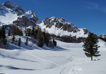
Trail Walking of 9.4 km to be discovered at Provence-Alpes-Côte d'Azur, Hautes-Alpes, Ceillac. This trail is proposed by stelh.
Description
Départ du parking "Les Claux". Montée douce pendant 1 km puis soutenue pour arriver au lac. Après le lac, très joli vallon, jusqu'au pierrer final ou une pente plus soutenue nous mène au col de Clausis. Retour par le même chemin
Positioning
Country:
France
Region :
Provence-Alpes-Côte d'Azur
Department/Province :
Hautes-Alpes
Municipality :
Ceillac
Location:
Unknown
Start:(Dec)
Start:(UTM)
329636 ; 4946630 (32T) N.
Comments
Trails nearby
![Trail Walking Ceillac - Col Girardin - Photo](https://media.geolcdn.com/t/375/260/9f962121-0428-4bc4-9d0a-3cac19ab6aaa.jpg&format=jpg&maxdim=2)
![Walking Walking](https://static1.geolcdn.com/sitytour/trail-icons/101.png)
Col Girardin
Walking
Very difficult
Ceillac,
Provence-Alpes-Côte d'Azur,
Hautes-Alpes,
France
![](/images/other/stat-length.png)
14.5 km | 29 km-effort
6h 32min
![](https://static1.geolcdn.com/siteimages/upload/files/16400158638029165_repeat_loop_refresh_sync_direction_icon.png)
Yes
![Trail Walking Ceillac - Queyras_lac de Clausis - Photo](https://media.geolcdn.com/t/375/260/ext.jpg?maxdim=2&url=https%3A%2F%2Fstatic1.geolcdn.com%2Fsiteimages%2Fupload%2Ffiles%2F1553511878bg_sport_marche.png)
![Walking Walking](https://static1.geolcdn.com/sitytour/trail-icons/101.png)
Queyras_lac de Clausis
Walking
Very easy
(1)
Ceillac,
Provence-Alpes-Côte d'Azur,
Hautes-Alpes,
France
![](/images/other/stat-length.png)
13.1 km | 26 km-effort
2h 59min
![](https://static1.geolcdn.com/siteimages/upload/files/16400158638029165_repeat_loop_refresh_sync_direction_icon.png)
Yes
![Trail Other activity Ceillac - Col de la petite Par. Col Girardin - Photo](https://media.geolcdn.com/t/375/260/ext.jpg?maxdim=2&url=https%3A%2F%2Fservices.sitytrail.com%2FGeolivesWS%2FDownloadMedia.ashx%3FTrailID%3D580882%26Media%3Dfix__20160521101555.jpg)
![Other activity Other activity](https://static1.geolcdn.com/sitytour/trail-icons/900.png)
Col de la petite Par. Col Girardin
Other activity
Difficult
Ceillac,
Provence-Alpes-Côte d'Azur,
Hautes-Alpes,
France
![](/images/other/stat-length.png)
13.9 km | 32 km-effort
7h 36min
![](https://static1.geolcdn.com/siteimages/upload/files/16400158638029165_repeat_loop_refresh_sync_direction_icon.png)
Yes
![Trail Walking Ceillac - le Longet ou tête du Rissace - Photo](https://media.geolcdn.com/t/375/260/ext.jpg?maxdim=2&url=https%3A%2F%2Fservices.sitytrail.com%2FGeolivesWS%2FDownloadMedia.ashx%3FTrailID%3D445510%26Media%3D9eb223c7-1561-4cc6-abdb-43f038b03708.JPG)
![Walking Walking](https://static1.geolcdn.com/sitytour/trail-icons/101.png)
le Longet ou tête du Rissace
Walking
Medium
Ceillac,
Provence-Alpes-Côte d'Azur,
Hautes-Alpes,
France
![](/images/other/stat-length.png)
13 km | 25 km-effort
6h 26min
![](https://static1.geolcdn.com/siteimages/upload/files/16400158638029165_repeat_loop_refresh_sync_direction_icon.png)
Yes
![Trail Walking Ceillac - Lac Ste Anne et Tête de Girardin - Photo](https://media.geolcdn.com/t/375/260/ext.jpg?maxdim=2&url=https%3A%2F%2Fservices.sitytrail.com%2FGeolivesWS%2FDownloadMedia.ashx%3FTrailID%3D324938%26Media%3Dfix__20140716140038.jpg)
![Walking Walking](https://static1.geolcdn.com/sitytour/trail-icons/101.png)
Lac Ste Anne et Tête de Girardin
Walking
Medium
Ceillac,
Provence-Alpes-Côte d'Azur,
Hautes-Alpes,
France
![](/images/other/stat-length.png)
14.4 km | 27 km-effort
5h 48min
![](https://static1.geolcdn.com/siteimages/upload/files/16400158638029165_repeat_loop_refresh_sync_direction_icon.png)
Yes
![Trail Walking Ceillac - lac Sainte Anne - Photo](https://media.geolcdn.com/t/375/260/ext.jpg?maxdim=2&url=https%3A%2F%2Fstatic1.geolcdn.com%2Fsiteimages%2Fupload%2Ffiles%2F1553511878bg_sport_marche.png)
![Walking Walking](https://static1.geolcdn.com/sitytour/trail-icons/101.png)
lac Sainte Anne
Walking
Easy
(2)
Ceillac,
Provence-Alpes-Côte d'Azur,
Hautes-Alpes,
France
![](/images/other/stat-length.png)
10.7 km | 17.9 km-effort
5h 16min
![](https://static1.geolcdn.com/siteimages/upload/files/16400158638029165_repeat_loop_refresh_sync_direction_icon.png)
No
![Trail Walking Ceillac - cols Tronchet et Girardin - Photo](https://media.geolcdn.com/t/375/260/cf0dc948-d683-46aa-82d1-7de4f0ef6cd8.jpg&format=jpg&maxdim=2)
![Walking Walking](https://static1.geolcdn.com/sitytour/trail-icons/101.png)
cols Tronchet et Girardin
Walking
Medium
Ceillac,
Provence-Alpes-Côte d'Azur,
Hautes-Alpes,
France
![](/images/other/stat-length.png)
13.8 km | 27 km-effort
7h 56min
![](https://static1.geolcdn.com/siteimages/upload/files/16400158638029165_repeat_loop_refresh_sync_direction_icon.png)
Yes
![Trail Snowshoes Ceillac - ceillac ste Anne lac mirroir 11kms 486m - Photo](https://media.geolcdn.com/t/375/260/bc759666-5776-496b-bc02-3e54abf80af8.jpg&format=jpg&maxdim=2)
![Snowshoes Snowshoes](https://static1.geolcdn.com/sitytour/trail-icons/504.png)
ceillac ste Anne lac mirroir 11kms 486m
Snowshoes
Medium
Ceillac,
Provence-Alpes-Côte d'Azur,
Hautes-Alpes,
France
![](/images/other/stat-length.png)
9.7 km | 16.5 km-effort
6h 57min
![](https://static1.geolcdn.com/siteimages/upload/files/16400158638029165_repeat_loop_refresh_sync_direction_icon.png)
No
![Trail Snowshoes Ceillac - Ceillac tronchet 11kms 586m - Photo](https://media.geolcdn.com/t/375/260/7aa13433-dd94-4eb4-a1a4-db7f915e2806.jpg&format=jpg&maxdim=2)
![Snowshoes Snowshoes](https://static1.geolcdn.com/sitytour/trail-icons/504.png)
Ceillac tronchet 11kms 586m
Snowshoes
Medium
Ceillac,
Provence-Alpes-Côte d'Azur,
Hautes-Alpes,
France
![](/images/other/stat-length.png)
10.5 km | 18.3 km-effort
6h 36min
![](https://static1.geolcdn.com/siteimages/upload/files/16400158638029165_repeat_loop_refresh_sync_direction_icon.png)
Yes