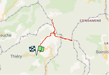
![](/images/other/stat-length.png)
![Trail Walking Thiéry - Brec d'Ilonse et pointe des 4 communes - Photo](https://media.geolcdn.com/t/1900/400/ext.pjpeg?maxdim=2&url=https%3A%2F%2Fstatic1.geolcdn.com%2Fsiteimages%2Fupload%2Ffiles%2F1553511878bg_sport_marche.png)
Brec d'Ilonse et pointe des 4 communes
domi06
User
![Length](/images/other/stat-length.png)
![Max alt](https://static1.geolcdn.com/siteimages/upload/files/1508320355ic_sort_altitude_max_24dp.png)
![Uphill gradient](https://static1.geolcdn.com/siteimages/upload/files/1508320355ic_sort_den_pos_24dp.png)
![Km-Effort](/images/other/stat-length.png)
![Min alt](https://static1.geolcdn.com/siteimages/upload/files/1508320355ic_sort_altitude_min_24dp.png)
![Downhill gradient](https://static1.geolcdn.com/siteimages/upload/files/1508320355ic_sort_den_neg_24dp.png)
![Boucle](https://static1.geolcdn.com/siteimages/upload/files/16400158638029165_repeat_loop_refresh_sync_direction_icon.png)
![Walking](https://static1.geolcdn.com/sitytour/trail-icons/101.png)
7h16
Difficulty : Medium
![Scan this QR Code to open this trail in the SityTrail application](https://capi.geolives.com/qq0zvz2zws4bq2lad0pu/sitytour/trails/3286714/qr.png?size=200)
FREE GPS app for hiking
About
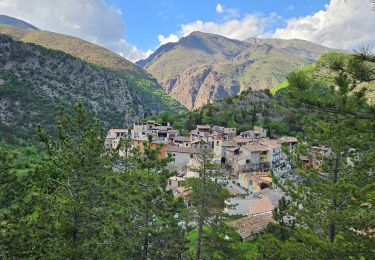
Trail Walking of 13.8 km to be discovered at Provence-Alpes-Côte d'Azur, Maritime Alps, Thiéry. This trail is proposed by domi06.
Description
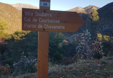
Départ du Col de la Madone Balise 81, puis montée en Nord-est en passant par les balises 82, 83 , 84 pour atteindre le col de Coubaisse (1629m) balise 216.Remonter au nord pour atteindre le Brec d'Ilonse (1738m) en passant par la balise 217. Revenir sur vos pas jusqu'au Col de Courbaisse pour monter plein Est vers la pointe des Quatre Cantons (1805m). Le retour se fait par le même sentier sans passer par le Brec d'Ilonse : balise 215, 216, 84, 83 , 82 et arrivée à la balise 81.
Cotation E4/T3/R3
Positioning
Comments
Trails nearby
![Trail On foot Massoins - Plateau du Lac - Photo](https://media.geolcdn.com/t/375/260/72458cd6-de82-448d-8f0e-f50b00abdc54.jpeg&format=jpg&maxdim=2)
![On foot On foot](https://static1.geolcdn.com/sitytour/trail-icons/100.png)
On foot
![](/images/other/stat-length.png)
![](https://static1.geolcdn.com/siteimages/upload/files/16400158638029165_repeat_loop_refresh_sync_direction_icon.png)
![Trail Walking Rigaud - Mairola de Rigaud, chapelles St Julien et St Sauveur - Photo](https://media.geolcdn.com/t/375/260/bfd975e4-5b26-4452-b5c4-4e8903bf1886.jpg&format=jpg&maxdim=2)
![Walking Walking](https://static1.geolcdn.com/sitytour/trail-icons/101.png)
Walking
![](/images/other/stat-length.png)
![](https://static1.geolcdn.com/siteimages/upload/files/16400158638029165_repeat_loop_refresh_sync_direction_icon.png)
![Trail Walking Touët-sur-Var - Touet sur Var - Photo](https://media.geolcdn.com/t/375/260/591991c8-678f-43ce-bfb4-52a24dbc47c8.jpg&format=jpg&maxdim=2)
![Walking Walking](https://static1.geolcdn.com/sitytour/trail-icons/101.png)
Walking
![](/images/other/stat-length.png)
![](https://static1.geolcdn.com/siteimages/upload/files/16400158638029165_repeat_loop_refresh_sync_direction_icon.png)
![Trail Walking Thiéry - Brec d’ Ilonse - Photo](https://media.geolcdn.com/t/375/260/371e8790-f558-4bbf-8168-94a56f4b21b9.jpg&format=jpg&maxdim=2)
![Walking Walking](https://static1.geolcdn.com/sitytour/trail-icons/101.png)
Walking
![](/images/other/stat-length.png)
![](https://static1.geolcdn.com/siteimages/upload/files/16400158638029165_repeat_loop_refresh_sync_direction_icon.png)
![Trail Walking Thiéry - thiery Villa Soubere - Photo](https://media.geolcdn.com/t/375/260/152e54b1-7917-4f58-90c1-fbc432530c5c.jpg&format=jpg&maxdim=2)
![Walking Walking](https://static1.geolcdn.com/sitytour/trail-icons/101.png)
Walking
![](/images/other/stat-length.png)
![](https://static1.geolcdn.com/siteimages/upload/files/16400158638029165_repeat_loop_refresh_sync_direction_icon.png)
![Trail Walking Thiéry - Pointe de Chavanette Par chapelle Ste Madeleine/Thiery - Photo](https://media.geolcdn.com/t/375/260/bf4c4b25-1f2c-4c16-b282-1fd0acf4f8e0.jpg&format=jpg&maxdim=2)
![Walking Walking](https://static1.geolcdn.com/sitytour/trail-icons/101.png)
Walking
![](/images/other/stat-length.png)
![](https://static1.geolcdn.com/siteimages/upload/files/16400158638029165_repeat_loop_refresh_sync_direction_icon.png)
![Trail Walking Lieuche - Lieuche brec d ilonse - Photo](https://media.geolcdn.com/t/375/260/b5e77ab5-d74f-4c03-aaca-8053a1eeae4f.jpg&format=jpg&maxdim=2)
![Walking Walking](https://static1.geolcdn.com/sitytour/trail-icons/101.png)
Walking
![](/images/other/stat-length.png)
![](https://static1.geolcdn.com/siteimages/upload/files/16400158638029165_repeat_loop_refresh_sync_direction_icon.png)
![Trail Walking Thiéry - mont fracha et brec d illons - Photo](https://media.geolcdn.com/t/375/260/7a352f20-95c8-4db5-abd7-afa376ae4d13.jpg&format=jpg&maxdim=2)
![Walking Walking](https://static1.geolcdn.com/sitytour/trail-icons/101.png)
Walking
![](/images/other/stat-length.png)
![](https://static1.geolcdn.com/siteimages/upload/files/16400158638029165_repeat_loop_refresh_sync_direction_icon.png)
![Trail On foot Touët-sur-Var - Traversée Touët-sur-Var – Villars-sur-Var - Photo](https://media.geolcdn.com/t/375/260/e3880c6a-e663-4d01-b142-f62d8840daf4.jpeg&format=jpg&maxdim=2)
![On foot On foot](https://static1.geolcdn.com/sitytour/trail-icons/100.png)
On foot
![](/images/other/stat-length.png)
![](https://static1.geolcdn.com/siteimages/upload/files/16400158638029165_repeat_loop_refresh_sync_direction_icon.png)