![](/images/other/stat-length.png)
![Trail Walking Casteil - les gourgs de Cady - Photo](https://media.geolcdn.com/t/1900/400/ext.pjpeg?maxdim=2&url=https%3A%2F%2Fservices.sitytrail.com%2FGeolivesWS%2FDownloadMedia.ashx%3FTrailID%3D328377%26Media%3Dfix__20140727142118.jpg)
les gourgs de Cady
MarieFrancoise
User
![Length](/images/other/stat-length.png)
Length
19.7 km
![Max alt](https://static1.geolcdn.com/siteimages/upload/files/1508320355ic_sort_altitude_max_24dp.png)
Max alt
2372 m
![Uphill gradient](https://static1.geolcdn.com/siteimages/upload/files/1508320355ic_sort_den_pos_24dp.png)
Uphill gradient
935 m
![Km-Effort](/images/other/stat-length.png)
Km-Effort
32 km
![Min alt](https://static1.geolcdn.com/siteimages/upload/files/1508320355ic_sort_altitude_min_24dp.png)
Min alt
1506 m
![Downhill gradient](https://static1.geolcdn.com/siteimages/upload/files/1508320355ic_sort_den_neg_24dp.png)
Downhill gradient
938 m
![Boucle](https://static1.geolcdn.com/siteimages/upload/files/16400158638029165_repeat_loop_refresh_sync_direction_icon.png)
Boucle
Yes
Creation date :
2019-05-27 16:41:03.56
Updated on :
2019-05-27 16:41:03.766
![Walking](https://static1.geolcdn.com/sitytour/trail-icons/101.png)
6h42
Difficulty : Medium
![Scan this QR Code to open this trail in the SityTrail application](https://capi.geolives.com/qq0zvz2zws4bq2lad0pu/sitytour/trails/328377/qr.png?size=200)
FREE GPS app for hiking
About
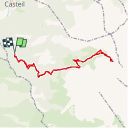
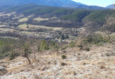
Trail Walking of 19.7 km to be discovered at Occitania, Pyrénées-Orientales, Casteil. This trail is proposed by MarieFrancoise.
Description
Départ du parking le Randé 1520 m.
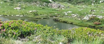
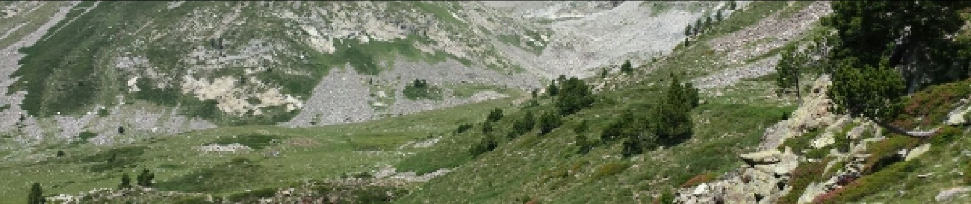
Rando très jolie et très agréable car montée progressive et paysages magnifiques.
En dehors de la période estivale possibilité de monter en voiture jusqu' au refuge des Marialles.
Positioning
Country:
France
Region :
Occitania
Department/Province :
Pyrénées-Orientales
Municipality :
Casteil
Location:
Unknown
Start:(Dec)
Start:(UTM)
450275 ; 4706210 (31T) N.
Comments
Trails nearby
![Trail Walking Casteil - rando casteil du cady - Photo](https://media.geolcdn.com/t/375/260/352b0394-d6dc-4c9d-b4d3-5f316da4dd05.jpg&format=jpg&maxdim=2)
![Walking Walking](https://static1.geolcdn.com/sitytour/trail-icons/101.png)
rando casteil du cady
Walking
Very easy
(1)
Casteil,
Occitania,
Pyrénées-Orientales,
France
![](/images/other/stat-length.png)
5.3 km | 8.7 km-effort
3h 16min
![](https://static1.geolcdn.com/siteimages/upload/files/16400158638029165_repeat_loop_refresh_sync_direction_icon.png)
No
![Trail Walking Vernet-les-Bains - La tour de Goa - Photo](https://media.geolcdn.com/t/375/260/ext.jpg?maxdim=2&url=https%3A%2F%2Fservices.sitytrail.com%2FGeolivesWS%2FDownloadMedia.ashx%3FTrailID%3D109701%26Media%3D4392_3.jpg)
![Walking Walking](https://static1.geolcdn.com/sitytour/trail-icons/101.png)
La tour de Goa
Walking
Difficult
(2)
Vernet-les-Bains,
Occitania,
Pyrénées-Orientales,
France
![](/images/other/stat-length.png)
15.4 km | 31 km-effort
6h 30min
![](https://static1.geolcdn.com/siteimages/upload/files/16400158638029165_repeat_loop_refresh_sync_direction_icon.png)
Yes
![Trail Walking Vernet-les-Bains - Cascade des Anglais à Vernet les Bains - Photo](https://media.geolcdn.com/t/375/260/ext.jpg?maxdim=2&url=https%3A%2F%2Fstatic1.geolcdn.com%2Fsiteimages%2Fupload%2Ffiles%2F1553511878bg_sport_marche.png)
![Walking Walking](https://static1.geolcdn.com/sitytour/trail-icons/101.png)
Cascade des Anglais à Vernet les Bains
Walking
Difficult
(1)
Vernet-les-Bains,
Occitania,
Pyrénées-Orientales,
France
![](/images/other/stat-length.png)
3.9 km | 6.6 km-effort
1h 34min
![](https://static1.geolcdn.com/siteimages/upload/files/16400158638029165_repeat_loop_refresh_sync_direction_icon.png)
Yes
![Trail Walking Sahorre - Mattes rouges - Photo](https://media.geolcdn.com/t/375/260/ext.jpg?maxdim=2&url=https%3A%2F%2Fservices.sitytrail.com%2FGeolivesWS%2FDownloadMedia.ashx%3FTrailID%3D161092%26Media%3D20121103105150.jpg)
![Walking Walking](https://static1.geolcdn.com/sitytour/trail-icons/101.png)
Mattes rouges
Walking
Medium
(1)
Sahorre,
Occitania,
Pyrénées-Orientales,
France
![](/images/other/stat-length.png)
11.5 km | 21 km-effort
4h 32min
![](https://static1.geolcdn.com/siteimages/upload/files/16400158638029165_repeat_loop_refresh_sync_direction_icon.png)
Yes
![Trail Walking Vernet-les-Bains - Tour de Goa - Vernet les Bains -Pyrénées Orientales - Photo](https://media.geolcdn.com/t/375/260/c3e59293-b0f6-4e05-8fb8-b01c4600098f.jpg&format=jpg&maxdim=2)
![Walking Walking](https://static1.geolcdn.com/sitytour/trail-icons/101.png)
Tour de Goa - Vernet les Bains -Pyrénées Orientales
Walking
Difficult
Vernet-les-Bains,
Occitania,
Pyrénées-Orientales,
France
![](/images/other/stat-length.png)
10.8 km | 18.8 km-effort
5h 37min
![](https://static1.geolcdn.com/siteimages/upload/files/16400158638029165_repeat_loop_refresh_sync_direction_icon.png)
Yes
![Trail Walking Vernet-les-Bains - vernet tours de badabali - Photo](https://media.geolcdn.com/t/375/260/cb56fc1d-584b-4a60-a4a1-cda4a3cc7c75.jpg&format=jpg&maxdim=2)
![Walking Walking](https://static1.geolcdn.com/sitytour/trail-icons/101.png)
vernet tours de badabali
Walking
Difficult
Vernet-les-Bains,
Occitania,
Pyrénées-Orientales,
France
![](/images/other/stat-length.png)
12.5 km | 17.3 km-effort
6h 18min
![](https://static1.geolcdn.com/siteimages/upload/files/16400158638029165_repeat_loop_refresh_sync_direction_icon.png)
Yes
![Trail Walking Vernet-les-Bains - plc de l'alzina départ chemin de la laiterie Vernet les Bains - Photo](https://media.geolcdn.com/t/375/260/340d308c-0d8c-4229-9e0f-cfbc8f15044e.jpg&format=jpg&maxdim=2)
![Walking Walking](https://static1.geolcdn.com/sitytour/trail-icons/101.png)
plc de l'alzina départ chemin de la laiterie Vernet les Bains
Walking
Medium
Vernet-les-Bains,
Occitania,
Pyrénées-Orientales,
France
![](/images/other/stat-length.png)
7.8 km | 12.4 km-effort
2h 32min
![](https://static1.geolcdn.com/siteimages/upload/files/16400158638029165_repeat_loop_refresh_sync_direction_icon.png)
Yes
![Trail On foot Vernet-les-Bains - la belle époque retour centre ville - Photo](https://media.geolcdn.com/t/375/260/ext.jpg?maxdim=2&url=https%3A%2F%2Fstatic1.geolcdn.com%2Fsiteimages%2Fupload%2Ffiles%2F1545311037marcheuse_200dpi.jpg)
![On foot On foot](https://static1.geolcdn.com/sitytour/trail-icons/100.png)
la belle époque retour centre ville
On foot
Easy
(1)
Vernet-les-Bains,
Occitania,
Pyrénées-Orientales,
France
![](/images/other/stat-length.png)
3.3 km | 4.8 km-effort
1h 5min
![](https://static1.geolcdn.com/siteimages/upload/files/16400158638029165_repeat_loop_refresh_sync_direction_icon.png)
Yes
![Trail Walking Vernet-les-Bains - Vernet 2 - Photo](https://media.geolcdn.com/t/375/260/53a7412d-1c6f-45c0-852d-a9035644c1a8.jpg&format=jpg&maxdim=2)
![Walking Walking](https://static1.geolcdn.com/sitytour/trail-icons/101.png)
Vernet 2
Walking
Medium
Vernet-les-Bains,
Occitania,
Pyrénées-Orientales,
France
![](/images/other/stat-length.png)
8.8 km | 14.9 km-effort
2h 27min
![](https://static1.geolcdn.com/siteimages/upload/files/16400158638029165_repeat_loop_refresh_sync_direction_icon.png)
No