Trail Walking Cervières - Les fonts de cervieres_SOULIERS - Photo

Les fonts de cervieres_SOULIERS

© OpenStreetMap contributors
Length
Length
17.2 km
Max alt
Max alt
2633 m
Uphill gradient
Uphill gradient
1103 m
Km-Effort
Km-Effort  
33 km
Min alt
Min alt
1851 m
Downhill gradient
Downhill gradient
1293 m
Boucle
Boucle
No
Creation date :
2022-05-23 19:11:15.546
Updated on :
2022-05-23 19:13:09.713

(0 Reviews)

Walking
Walking
7h23
Difficulty : Medium

Scan this QR Code to open this trail in the SityTrail application

FREE GPS app for hiking

Logo SityTrail SityTrail

IGN / Geographical institutes

Download SityTrail from the App Store Download SityTrail from Google Play

Logo SityTrail SityTrail World

The world is yours!

Download SityTrail from the App Store Download SityTrail from Google Play Download SityTrail on Huawei AppGallery

About

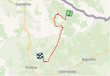
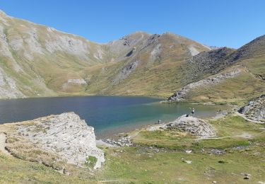
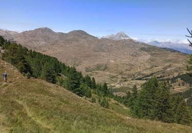
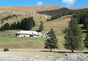
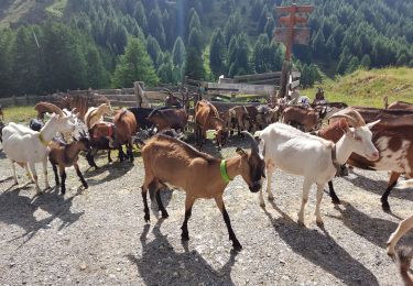
Trail Walking of 17.2 km to be discovered at Provence-Alpes-Côte d'Azur, Hautes-Alpes, Cervières. This trail is proposed by Le grand Claude.

Description

long:17 km
Alt max: 2633m
Delta  : 1103m
Delta - : 1293m

Elevation profile

Positioning

Country:
France
Region :
Provence-Alpes-Côte d'Azur
Department/Province :
Hautes-Alpes
Municipality :
Cervières
Location:
Unknown
Start:(UTM)
327400 ; 4967959 (32T) N.

Trails nearby

Trail Walking Cervières - Le Petit rochebrune par col de péas - Photo
Walking
GUIDE
amiral13

Walking

Difficult
Cervières, Provence-Alpes-Côte d'Azur, Hautes-Alpes, France
15.2 km | 31 km-effort
8h 8min
Yes
Trail Walking Cervières - le lac des Cordes et le pic du vallon Crouzet - Photo
Walking
GUIDE
amiral13

Walking

Easy
Cervières, Provence-Alpes-Côte d'Azur, Hautes-Alpes, France
11.8 km | 22 km-effort
4h 26min
Yes
Trail Walking Aiguilles - les lacs du Malrifs - Photo
Walking
GUIDE
amiral13

Walking

Very easy
Aiguilles, Provence-Alpes-Côte d'Azur, Hautes-Alpes, France
11 km | 21 km-effort
4h 44min
Yes
Trail Walking Cervières - Circuit du Lac des Cordes - Photo
Walking
GuyVachet

Walking

Difficult
Cervières, Provence-Alpes-Côte d'Azur, Hautes-Alpes, France
8.7 km | 17.2 km-effort
3h 55min
Yes
Trail Touring skiing Cervières - PT 2944 crête de Dormillouse  - Photo
Touring skiing
GUIDE
nadd73

Touring skiing

Medium
Cervières, Provence-Alpes-Côte d'Azur, Hautes-Alpes, France
8.7 km | 12.6 km-effort
1h 25min
No
Trail Walking Aiguilles - lacs malrif à partir du lombard - Photo
Walking
francoisBerg

Walking

Medium
Aiguilles, Provence-Alpes-Côte d'Azur, Hautes-Alpes, France
9.8 km | 19.4 km-effort
3h 45min
Yes
Trail Walking Cervières - le lasseron col de chaude maison  - Photo
Walking
Evenc

Walking

Difficult
Cervières, Provence-Alpes-Côte d'Azur, Hautes-Alpes, France
13.3 km | 28 km-effort
9h 54min
Yes
Trail Walking Cervières - Le Lac des cordes  - Photo
Walking
Sorriaux

Walking

Difficult
Cervières, Provence-Alpes-Côte d'Azur, Hautes-Alpes, France
10 km | 18.7 km-effort
3h 42min
No
Trail Walking Cervières - Arsem Les fonts de Cervieres - Photo
Walking
labarone

Walking

Medium
Cervières, Provence-Alpes-Côte d'Azur, Hautes-Alpes, France
13.4 km | 23 km-effort
5h 44min
No


Close
My subscriptions