![](/images/other/stat-length.png)
![Trail Walking Valbelle - Tour de Sumiou - Photo](https://media.geolcdn.com/t/1900/400/98046d43-9799-41dd-91ec-957f42022344.jpg&format=pjpeg&maxdim=2)
Tour de Sumiou
Marco05
User GUIDE
![Length](/images/other/stat-length.png)
Length
13.4 km
![Max alt](https://static1.geolcdn.com/siteimages/upload/files/1508320355ic_sort_altitude_max_24dp.png)
Max alt
1253 m
![Uphill gradient](https://static1.geolcdn.com/siteimages/upload/files/1508320355ic_sort_den_pos_24dp.png)
Uphill gradient
726 m
![Km-Effort](/images/other/stat-length.png)
Km-Effort
23 km
![Min alt](https://static1.geolcdn.com/siteimages/upload/files/1508320355ic_sort_altitude_min_24dp.png)
Min alt
544 m
![Downhill gradient](https://static1.geolcdn.com/siteimages/upload/files/1508320355ic_sort_den_neg_24dp.png)
Downhill gradient
719 m
![Boucle](https://static1.geolcdn.com/siteimages/upload/files/16400158638029165_repeat_loop_refresh_sync_direction_icon.png)
Boucle
No
Creation date :
2022-04-01 12:05:12.376
Updated on :
2022-12-17 16:13:27.571
![Walking](https://static1.geolcdn.com/sitytour/trail-icons/101.png)
5h14
Difficulty : Difficult
![Scan this QR Code to open this trail in the SityTrail application](https://capi.geolives.com/qq0zvz2zws4bq2lad0pu/sitytour/trails/3188274/qr.png?size=200)
FREE GPS app for hiking
About
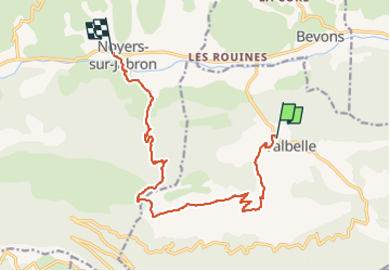
Trail Walking of 13.4 km to be discovered at Provence-Alpes-Côte d'Azur, Alpes-de-Haute-Provence, Valbelle. This trail is proposed by Marco05.
Description
Pour cette jolie randonnée au dessus de Noyers-sur-Jabron, il faut deux voitures.
Une, garée au départ à Valbelle, et l'autre à l'arrivée à Noyers.
Pas de grosses difficultés sauf la longueur de 13km.
Positioning
Country:
France
Region :
Provence-Alpes-Côte d'Azur
Department/Province :
Alpes-de-Haute-Provence
Municipality :
Valbelle
Location:
Unknown
Start:(Dec)
Start:(UTM)
730091 ; 4892511 (31T) N.
Comments
Trails nearby
![Trail Walking Valbelle - VALBELLE . Chemin de Sara o l s - Photo](https://media.geolcdn.com/t/375/260/f5bc0f94-fea9-4cf8-899a-951c04f93f5f.jpg&format=jpg&maxdim=2)
![Walking Walking](https://static1.geolcdn.com/sitytour/trail-icons/101.png)
VALBELLE . Chemin de Sara o l s
Walking
Medium
(1)
Valbelle,
Provence-Alpes-Côte d'Azur,
Alpes-de-Haute-Provence,
France
![](/images/other/stat-length.png)
13.2 km | 19.7 km-effort
4h 47min
![](https://static1.geolcdn.com/siteimages/upload/files/16400158638029165_repeat_loop_refresh_sync_direction_icon.png)
Yes
![Trail Walking Valbelle - 05 chap st Pons col sumiou zel - Photo](https://media.geolcdn.com/t/375/260/654eadec-c68c-403c-8c9b-a622285d41ca.jpg&format=jpg&maxdim=2)
![Walking Walking](https://static1.geolcdn.com/sitytour/trail-icons/101.png)
05 chap st Pons col sumiou zel
Walking
Difficult
Valbelle,
Provence-Alpes-Côte d'Azur,
Alpes-de-Haute-Provence,
France
![](/images/other/stat-length.png)
11 km | 21 km-effort
5h 40min
![](https://static1.geolcdn.com/siteimages/upload/files/16400158638029165_repeat_loop_refresh_sync_direction_icon.png)
Yes
![Trail Walking Valbelle - chapelle saint Pont et montagne Sumiou - Photo](https://media.geolcdn.com/t/375/260/36d6cde7-c446-427e-9ab1-73d7e5890674.jpg&format=jpg&maxdim=2)
![Walking Walking](https://static1.geolcdn.com/sitytour/trail-icons/101.png)
chapelle saint Pont et montagne Sumiou
Walking
Difficult
Valbelle,
Provence-Alpes-Côte d'Azur,
Alpes-de-Haute-Provence,
France
![](/images/other/stat-length.png)
21 km | 34 km-effort
5h 11min
![](https://static1.geolcdn.com/siteimages/upload/files/16400158638029165_repeat_loop_refresh_sync_direction_icon.png)
Yes
![Trail On foot Noyers-sur-Jabron - Montagne de Sumiou - Grotte des Peyrouets_19_01_2024 - Photo](https://media.geolcdn.com/t/375/260/d885e4ac-abdf-4f73-b427-5e5b97ac821b.jpg&format=jpg&maxdim=2)
![On foot On foot](https://static1.geolcdn.com/sitytour/trail-icons/100.png)
Montagne de Sumiou - Grotte des Peyrouets_19_01_2024
On foot
Medium
Noyers-sur-Jabron,
Provence-Alpes-Côte d'Azur,
Alpes-de-Haute-Provence,
France
![](/images/other/stat-length.png)
16 km | 24 km-effort
5h 32min
![](https://static1.geolcdn.com/siteimages/upload/files/16400158638029165_repeat_loop_refresh_sync_direction_icon.png)
Yes
![Trail Walking Valbelle - 04 chapelle St Pons 03.08.23 - Photo](https://media.geolcdn.com/t/375/260/a22dc00e-ca36-48e1-a26c-c25718a9238f.jpg&format=jpg&maxdim=2)
![Walking Walking](https://static1.geolcdn.com/sitytour/trail-icons/101.png)
04 chapelle St Pons 03.08.23
Walking
Difficult
Valbelle,
Provence-Alpes-Côte d'Azur,
Alpes-de-Haute-Provence,
France
![](/images/other/stat-length.png)
8.2 km | 13.6 km-effort
3h 27min
![](https://static1.geolcdn.com/siteimages/upload/files/16400158638029165_repeat_loop_refresh_sync_direction_icon.png)
No
![Trail Walking Sisteron - BEVONS crêtes de Chapage o l s m - Photo](https://media.geolcdn.com/t/375/260/06496741-537d-4e32-9a57-13673b07b6c5.jpg&format=jpg&maxdim=2)
![Walking Walking](https://static1.geolcdn.com/sitytour/trail-icons/101.png)
BEVONS crêtes de Chapage o l s m
Walking
Medium
Sisteron,
Provence-Alpes-Côte d'Azur,
Alpes-de-Haute-Provence,
France
![](/images/other/stat-length.png)
8.2 km | 15 km-effort
2h 37min
![](https://static1.geolcdn.com/siteimages/upload/files/16400158638029165_repeat_loop_refresh_sync_direction_icon.png)
Yes
![Trail On foot Valbelle - Montagne de Lure - Photo](https://media.geolcdn.com/t/375/260/d2f7e93b-ac8d-4890-bbc4-c62d8ad565bf.jpg&format=jpg&maxdim=2)
![On foot On foot](https://static1.geolcdn.com/sitytour/trail-icons/100.png)
Montagne de Lure
On foot
Difficult
Valbelle,
Provence-Alpes-Côte d'Azur,
Alpes-de-Haute-Provence,
France
![](/images/other/stat-length.png)
20 km | 35 km-effort
7h 54min
![](https://static1.geolcdn.com/siteimages/upload/files/16400158638029165_repeat_loop_refresh_sync_direction_icon.png)
Yes
![Trail Walking Valbelle - Valbelle - Chapelle Saint Pons - Photo](https://media.geolcdn.com/t/375/260/ext.jpg?maxdim=2&url=https%3A%2F%2Fstatic1.geolcdn.com%2Fsiteimages%2Fupload%2Ffiles%2F1553511878bg_sport_marche.png)
![Walking Walking](https://static1.geolcdn.com/sitytour/trail-icons/101.png)
Valbelle - Chapelle Saint Pons
Walking
Medium
(1)
Valbelle,
Provence-Alpes-Côte d'Azur,
Alpes-de-Haute-Provence,
France
![](/images/other/stat-length.png)
5.5 km | 10.6 km-effort
2h 20min
![](https://static1.geolcdn.com/siteimages/upload/files/16400158638029165_repeat_loop_refresh_sync_direction_icon.png)
Yes
![Trail Walking Noyers-sur-Jabron - Montagne de Lure (boucle) - Photo](https://media.geolcdn.com/t/375/260/ext.jpg?maxdim=2&url=https%3A%2F%2Fstatic1.geolcdn.com%2Fsiteimages%2Fupload%2Ffiles%2F1553511878bg_sport_marche.png)
![Walking Walking](https://static1.geolcdn.com/sitytour/trail-icons/101.png)
Montagne de Lure (boucle)
Walking
Difficult
(2)
Noyers-sur-Jabron,
Provence-Alpes-Côte d'Azur,
Alpes-de-Haute-Provence,
France
![](/images/other/stat-length.png)
12.6 km | 21 km-effort
4h 0min
![](https://static1.geolcdn.com/siteimages/upload/files/16400158638029165_repeat_loop_refresh_sync_direction_icon.png)
Yes