![](/images/other/stat-length.png)
![Trail On foot Gazzaniga - Sentiero 522: Gazzaniga - Cà de Spì - Photo](https://media.geolcdn.com/t/1900/400/9ca92b27-d19a-4869-838b-66199694d2a5.jpeg&format=pjpeg&maxdim=2)
Sentiero 522: Gazzaniga - Cà de Spì
SityTrail - itinéraires balisés pédestres
Tous les sentiers balisés d’Europe GUIDE+
![Length](/images/other/stat-length.png)
![Max alt](https://static1.geolcdn.com/siteimages/upload/files/1508320355ic_sort_altitude_max_24dp.png)
![Uphill gradient](https://static1.geolcdn.com/siteimages/upload/files/1508320355ic_sort_den_pos_24dp.png)
![Km-Effort](/images/other/stat-length.png)
![Min alt](https://static1.geolcdn.com/siteimages/upload/files/1508320355ic_sort_altitude_min_24dp.png)
![Downhill gradient](https://static1.geolcdn.com/siteimages/upload/files/1508320355ic_sort_den_neg_24dp.png)
![Boucle](https://static1.geolcdn.com/siteimages/upload/files/16400158638029165_repeat_loop_refresh_sync_direction_icon.png)
![On foot](https://static1.geolcdn.com/sitytour/trail-icons/100.png)
2h17
Difficulty : Easy
![Scan this QR Code to open this trail in the SityTrail application](https://capi.geolives.com/qq0zvz2zws4bq2lad0pu/sitytour/trails/3112748/qr.png?size=200)
FREE GPS app for hiking
About
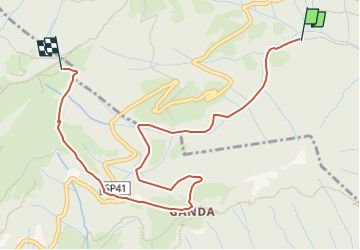
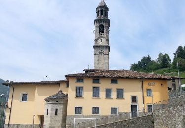
Trail On foot of 4.3 km to be discovered at Lombardy, Bergamo, Gazzaniga. This trail is proposed by SityTrail - itinéraires balisés pédestres.
Description
Dalla chiesa parrocchiale di Gazzaniga si sale alla chiesetta di S. Rocco, poi ci si inoltra nella valle sino a giungere alla cappelletta della Gelada (bivio con il sentiero 521A) e si continua fino a incontrare la chiesetta del Ruclisciù.
Website: http://geoportale.caibergamo.it/sentiero/522
Positioning
Comments
Trails nearby
![Trail On foot Albino - CAI 512 - Photo](https://media.geolcdn.com/t/375/260/355af884-ab3b-4ab1-8bdd-e4300bac648d.jpeg&format=jpg&maxdim=2)
![On foot On foot](https://static1.geolcdn.com/sitytour/trail-icons/100.png)
![Trail On foot Nembro - Sentiero 536: Trevasco (Nembro) - Selvino - Photo](https://media.geolcdn.com/t/375/260/1e205f2e-365b-41ac-ac73-ff0529e96084.jpeg&format=jpg&maxdim=2)
![On foot On foot](https://static1.geolcdn.com/sitytour/trail-icons/100.png)
On foot
![](/images/other/stat-length.png)
![](https://static1.geolcdn.com/siteimages/upload/files/16400158638029165_repeat_loop_refresh_sync_direction_icon.png)
![Trail On foot Vertova - Il Sentiero di San Patrizio - Photo](https://media.geolcdn.com/t/375/260/407c495f-87eb-43e6-8122-9b345db660b5.jpeg&format=jpg&maxdim=2)
![On foot On foot](https://static1.geolcdn.com/sitytour/trail-icons/100.png)
On foot
![](/images/other/stat-length.png)
![](https://static1.geolcdn.com/siteimages/upload/files/16400158638029165_repeat_loop_refresh_sync_direction_icon.png)
![Trail On foot Gazzaniga - Sentiero 521: Rova (Gazzaniga) - Monte Cornagera - Photo](https://media.geolcdn.com/t/375/260/d72bf981-700c-4b40-85ab-18249d2c50a7.jpeg&format=jpg&maxdim=2)
![On foot On foot](https://static1.geolcdn.com/sitytour/trail-icons/100.png)
On foot
![](/images/other/stat-length.png)
![](https://static1.geolcdn.com/siteimages/upload/files/16400158638029165_repeat_loop_refresh_sync_direction_icon.png)
![Trail On foot Gazzaniga - Sentiero 524: Ösciöl (Orezzo) - incrocio sentiero 519 - Photo](https://media.geolcdn.com/t/375/260/e697bc1e-fcc7-4b11-a263-f0b0ecb11810.jpeg&format=jpg&maxdim=2)
![On foot On foot](https://static1.geolcdn.com/sitytour/trail-icons/100.png)
On foot
![](/images/other/stat-length.png)
![](https://static1.geolcdn.com/siteimages/upload/files/16400158638029165_repeat_loop_refresh_sync_direction_icon.png)
![Trail On foot Selvino - Sentiero 515: Albino - Selvino (Masu) - Photo](https://media.geolcdn.com/t/375/260/2d0d4309-5a55-443c-ad9d-ac784b1f603d.jpeg&format=jpg&maxdim=2)
![On foot On foot](https://static1.geolcdn.com/sitytour/trail-icons/100.png)
On foot
![](/images/other/stat-length.png)
![](https://static1.geolcdn.com/siteimages/upload/files/16400158638029165_repeat_loop_refresh_sync_direction_icon.png)