Trail On foot Steinheim - Vinsebeck - Photo

Tous les sentiers balisés d’Europe PRO

© OpenStreetMap contributors
Length
Length
3.6 km
Max alt
Max alt
165 m
Uphill gradient
Uphill gradient
20 m
Km-Effort
Km-Effort  
3.9 km
Min alt
Min alt
149 m
Downhill gradient
Downhill gradient
18 m
Boucle
Boucle
Yes
Signpost
Signpost
Creation date :
2022-02-11 20:04:14.168
Updated on :
2022-02-11 20:04:14.168

(0 Reviews)

On foot
On foot
52m
Difficulty : Easy

Scan this QR Code to open this trail in the SityTrail application

FREE GPS app for hiking

Logo SityTrail SityTrail

IGN / Geographical institutes

Download SityTrail from the App Store Download SityTrail from Google Play

Logo SityTrail SityTrail World

The world is yours!

Download SityTrail from the App Store Download SityTrail from Google Play Download SityTrail on Huawei AppGallery

About

Trail On foot of 3.6 km to be discovered at North Rhine-Westphalia, Kreis Höxter, Steinheim. This trail is proposed by SityTrail - itinéraires balisés pédestres.

Photos

Positioning

Country:
Germany
Region :
North Rhine-Westphalia
Department/Province :
Kreis Höxter
Municipality :
Steinheim
Location:
Unknown
Start:(UTM)
502122 ; 5744296 (32U) N.

Trails nearby

Trail On foot Steinheim - Rundwanderweg A1 [Grevenhagen] - Photo
On foot
PRO

On foot

Easy
Steinheim, North Rhine-Westphalia, Kreis Höxter, Germany
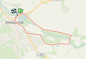
8.3 km | 11 km-effort
2h 30min
Yes
Trail On foot Horn-Bad Meinberg - Terrainkurweg 5 [Bad Meinberg] - Photo
On foot
PRO

On foot

Easy
Horn-Bad Meinberg, North Rhine-Westphalia, Kreis Lippe, Germany
3.3 km | 3.9 km-effort
53min
Yes
Trail On foot Horn-Bad Meinberg - Norderteich-Rundwanderweg [Billerbeck / Entenkrug] - Photo
On foot
PRO

On foot

Easy
Horn-Bad Meinberg, North Rhine-Westphalia, Kreis Lippe, Germany
3.4 km | 4 km-effort
54min
No
Trail On foot Horn-Bad Meinberg - Rundwanderweg [Entenkrug / Belle] - Photo
On foot
PRO

On foot

Easy
Horn-Bad Meinberg, North Rhine-Westphalia, Kreis Lippe, Germany
7.8 km | 9.8 km-effort
2h 13min
Yes
Trail On foot Horn-Bad Meinberg - Rundwanderweg A2 [Schauinsland / Entenkrug] - Photo
On foot
PRO

On foot

Easy
Horn-Bad Meinberg, North Rhine-Westphalia, Kreis Lippe, Germany
3.2 km | 4.1 km-effort
55min
No
Trail On foot Steinheim - Rundwanderweg A4 bei Steinheim - Photo
On foot
PRO

On foot

Easy
Steinheim, North Rhine-Westphalia, Kreis Höxter, Germany
6.1 km | 7.4 km-effort
1h 41min
Yes
Trail On foot Steinheim - Rundwanderweg A3 bei Steinheim - Photo
On foot
PRO

On foot

Easy
Steinheim, North Rhine-Westphalia, Kreis Höxter, Germany
3.4 km | 4.3 km-effort
58min
Yes
Trail On foot Steinheim - Vinsebeck - Photo
On foot
PRO

On foot

Easy
Steinheim, North Rhine-Westphalia, Kreis Höxter, Germany
3.8 km | 4.8 km-effort
1h 5min
Yes
Trail On foot Steinheim - Vinsebeck - Photo
On foot
PRO

On foot

Easy
Steinheim, North Rhine-Westphalia, Kreis Höxter, Germany
3.7 km | 4.7 km-effort
1h 4min
Yes


Close
My subscriptions