![](/images/other/stat-length.png)
![Trail On foot Südheide - Südheide 'Der Urwald im Lüß' W8l (lange Tour) - Photo](https://media.geolcdn.com/t/1900/400/bf2d9f67-29a0-4654-93f3-4c87af8cf9a5.jpeg&format=pjpeg&maxdim=2)
Südheide 'Der Urwald im Lüß' W8l (lange Tour)
SityTrail - itinéraires balisés pédestres
Tous les sentiers balisés d’Europe GUIDE+
![Length](/images/other/stat-length.png)
Length
14.4 km
![Max alt](https://static1.geolcdn.com/siteimages/upload/files/1508320355ic_sort_altitude_max_24dp.png)
Max alt
139 m
![Uphill gradient](https://static1.geolcdn.com/siteimages/upload/files/1508320355ic_sort_den_pos_24dp.png)
Uphill gradient
120 m
![Km-Effort](/images/other/stat-length.png)
Km-Effort
16 km
![Min alt](https://static1.geolcdn.com/siteimages/upload/files/1508320355ic_sort_altitude_min_24dp.png)
Min alt
107 m
![Downhill gradient](https://static1.geolcdn.com/siteimages/upload/files/1508320355ic_sort_den_neg_24dp.png)
Downhill gradient
124 m
![Boucle](https://static1.geolcdn.com/siteimages/upload/files/16400158638029165_repeat_loop_refresh_sync_direction_icon.png)
Boucle
Yes
Signpost
Creation date :
2022-02-11 19:51:17.624
Updated on :
2022-02-11 19:51:17.624
![On foot](https://static1.geolcdn.com/sitytour/trail-icons/100.png)
3h38
Difficulty : Easy
![Scan this QR Code to open this trail in the SityTrail application](https://capi.geolives.com/qq0zvz2zws4bq2lad0pu/sitytour/trails/3101162/qr.png?size=200)
FREE GPS app for hiking
About
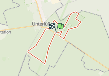
Trail On foot of 14.4 km to be discovered at Lower Saxony, Landkreis Celle, Südheide. This trail is proposed by SityTrail - itinéraires balisés pédestres.
Description
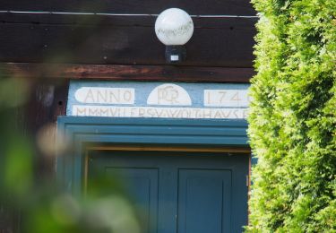
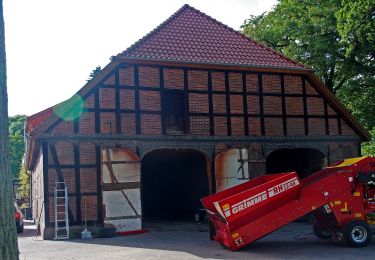
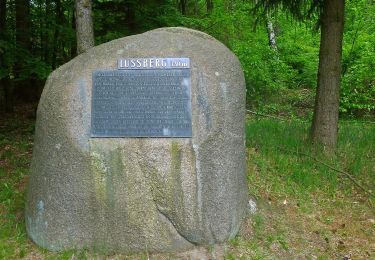
Die Wanderung als Rundweg führt durch das ausgedehnte Waldgebiet südlich von Unterlüß: einem echten Urwald!
Website: https://www.lueneburger-heide.de/9172
Positioning
Country:
Germany
Region :
Lower Saxony
Department/Province :
Landkreis Celle
Municipality :
Südheide
Location:
Unterluess
Start:(Dec)
Start:(UTM)
588541 ; 5853974 (32U) N.
Comments
Trails nearby
![Trail On foot Südheide - Südheide 'Gauß'scher Vermessungspunkt im Bergland der Südheide' W7m (mittlere Tour) - Photo](https://media.geolcdn.com/t/375/260/a7f8ab60-3650-4396-99b1-73fbb949c38a.jpeg&format=jpg&maxdim=2)
![On foot On foot](https://static1.geolcdn.com/sitytour/trail-icons/100.png)
Südheide 'Gauß'scher Vermessungspunkt im Bergland der Südheide' W7m (mittlere...
On foot
Easy
Südheide,
Lower Saxony,
Landkreis Celle,
Germany
![](/images/other/stat-length.png)
8.3 km | 9.2 km-effort
2h 5min
![](https://static1.geolcdn.com/siteimages/upload/files/16400158638029165_repeat_loop_refresh_sync_direction_icon.png)
Yes
![Trail On foot Südheide - Südheide 'Gauß'scher Vermessungspunkt im Bergland der Südheide' W7l (lange Tour) - Photo](https://media.geolcdn.com/t/375/260/54bf5156-66e4-415f-8629-aa416bfecc07.jpeg&format=jpg&maxdim=2)
![On foot On foot](https://static1.geolcdn.com/sitytour/trail-icons/100.png)
Südheide 'Gauß'scher Vermessungspunkt im Bergland der Südheide' W7l (lange Tour)
On foot
Easy
Südheide,
Lower Saxony,
Landkreis Celle,
Germany
![](/images/other/stat-length.png)
18 km | 19.8 km-effort
4h 29min
![](https://static1.geolcdn.com/siteimages/upload/files/16400158638029165_repeat_loop_refresh_sync_direction_icon.png)
Yes
![Trail On foot Eschede - Südheide 'Im Skandinavien der Südheide' W13k (kurze Tour) - Photo](https://media.geolcdn.com/t/375/260/133ba32a-386a-43aa-bf75-d45397cbf060.jpeg&format=jpg&maxdim=2)
![On foot On foot](https://static1.geolcdn.com/sitytour/trail-icons/100.png)
Südheide 'Im Skandinavien der Südheide' W13k (kurze Tour)
On foot
Easy
Eschede,
Lower Saxony,
Landkreis Celle,
Germany
![](/images/other/stat-length.png)
5.6 km | 6.3 km-effort
1h 25min
![](https://static1.geolcdn.com/siteimages/upload/files/16400158638029165_repeat_loop_refresh_sync_direction_icon.png)
Yes
![Trail On foot Eschede - Südheide 'Im Skandinavien der Südheide' W13l (lange Tour) - Photo](https://media.geolcdn.com/t/375/260/07e5b7c3-219f-479d-9728-cc242d341547.jpeg&format=jpg&maxdim=2)
![On foot On foot](https://static1.geolcdn.com/sitytour/trail-icons/100.png)
Südheide 'Im Skandinavien der Südheide' W13l (lange Tour)
On foot
Medium
Eschede,
Lower Saxony,
Landkreis Celle,
Germany
![](/images/other/stat-length.png)
18.6 km | 21 km-effort
4h 44min
![](https://static1.geolcdn.com/siteimages/upload/files/16400158638029165_repeat_loop_refresh_sync_direction_icon.png)
Yes
![Trail On foot Südheide - Südheide 'Wo die Wölfe ihre Fährten ziehen' W9k (kurze Tour) - Photo](https://media.geolcdn.com/t/375/260/a2b98ccf-cf4d-4784-b114-7ee855606f4f.jpeg&format=jpg&maxdim=2)
![On foot On foot](https://static1.geolcdn.com/sitytour/trail-icons/100.png)
Südheide 'Wo die Wölfe ihre Fährten ziehen' W9k (kurze Tour)
On foot
Easy
Südheide,
Lower Saxony,
Landkreis Celle,
Germany
![](/images/other/stat-length.png)
5.4 km | 5.9 km-effort
1h 19min
![](https://static1.geolcdn.com/siteimages/upload/files/16400158638029165_repeat_loop_refresh_sync_direction_icon.png)
Yes
![Trail On foot Südheide - Südheide 'Wo die Wölfe ihre Fährten ziehen' W9m (mittlere Tour) - Photo](https://media.geolcdn.com/t/375/260/1efe375e-7b22-4b59-88bf-83b5b23e48a3.jpeg&format=jpg&maxdim=2)
![On foot On foot](https://static1.geolcdn.com/sitytour/trail-icons/100.png)
Südheide 'Wo die Wölfe ihre Fährten ziehen' W9m (mittlere Tour)
On foot
Easy
Südheide,
Lower Saxony,
Landkreis Celle,
Germany
![](/images/other/stat-length.png)
10.9 km | 12 km-effort
2h 43min
![](https://static1.geolcdn.com/siteimages/upload/files/16400158638029165_repeat_loop_refresh_sync_direction_icon.png)
Yes
![Trail On foot Südheide - Südheide 'Wo die Wölfe ihre Fährten ziehen' W9l (lange Tour) - Photo](https://media.geolcdn.com/t/375/260/1efe375e-7b22-4b59-88bf-83b5b23e48a3.jpeg&format=jpg&maxdim=2)
![On foot On foot](https://static1.geolcdn.com/sitytour/trail-icons/100.png)
Südheide 'Wo die Wölfe ihre Fährten ziehen' W9l (lange Tour)
On foot
Easy
Südheide,
Lower Saxony,
Landkreis Celle,
Germany
![](/images/other/stat-length.png)
13.1 km | 14.3 km-effort
3h 14min
![](https://static1.geolcdn.com/siteimages/upload/files/16400158638029165_repeat_loop_refresh_sync_direction_icon.png)
Yes
![Trail On foot Südheide - Südheide 'Der Urwald im Lüß' W8m (mittlere Tour) - Photo](https://media.geolcdn.com/t/375/260/bf2d9f67-29a0-4654-93f3-4c87af8cf9a5.jpeg&format=jpg&maxdim=2)
![On foot On foot](https://static1.geolcdn.com/sitytour/trail-icons/100.png)
Südheide 'Der Urwald im Lüß' W8m (mittlere Tour)
On foot
Easy
Südheide,
Lower Saxony,
Landkreis Celle,
Germany
![](/images/other/stat-length.png)
10.7 km | 12 km-effort
2h 44min
![](https://static1.geolcdn.com/siteimages/upload/files/16400158638029165_repeat_loop_refresh_sync_direction_icon.png)
Yes
![Trail On foot Südheide - Südheide 'Der Urwald im Lüß' W8k (kurze Tour) - Photo](https://media.geolcdn.com/t/375/260/bf2d9f67-29a0-4654-93f3-4c87af8cf9a5.jpeg&format=jpg&maxdim=2)
![On foot On foot](https://static1.geolcdn.com/sitytour/trail-icons/100.png)
Südheide 'Der Urwald im Lüß' W8k (kurze Tour)
On foot
Easy
Südheide,
Lower Saxony,
Landkreis Celle,
Germany
![](/images/other/stat-length.png)
7.2 km | 8.1 km-effort
1h 49min
![](https://static1.geolcdn.com/siteimages/upload/files/16400158638029165_repeat_loop_refresh_sync_direction_icon.png)
Yes