![](/images/other/stat-length.png)
![Trail On foot Willebadessen - Erlesene Natur - Schmetterlingspfad Willebadessen - Photo](https://media.geolcdn.com/t/1900/400/1d1e46bc-a96d-4488-b777-85fd542936a8.jpeg&format=pjpeg&maxdim=2)
Erlesene Natur - Schmetterlingspfad Willebadessen
SityTrail - itinéraires balisés pédestres
Tous les sentiers balisés d’Europe GUIDE+
![Length](/images/other/stat-length.png)
Length
3.2 km
![Max alt](https://static1.geolcdn.com/siteimages/upload/files/1508320355ic_sort_altitude_max_24dp.png)
Max alt
311 m
![Uphill gradient](https://static1.geolcdn.com/siteimages/upload/files/1508320355ic_sort_den_pos_24dp.png)
Uphill gradient
88 m
![Km-Effort](/images/other/stat-length.png)
Km-Effort
4.2 km
![Min alt](https://static1.geolcdn.com/siteimages/upload/files/1508320355ic_sort_altitude_min_24dp.png)
Min alt
219 m
![Downhill gradient](https://static1.geolcdn.com/siteimages/upload/files/1508320355ic_sort_den_neg_24dp.png)
Downhill gradient
11 m
![Boucle](https://static1.geolcdn.com/siteimages/upload/files/16400158638029165_repeat_loop_refresh_sync_direction_icon.png)
Boucle
No
Signpost
Creation date :
2022-02-11 14:22:45.032
Updated on :
2022-02-11 14:22:45.032
![On foot](https://static1.geolcdn.com/sitytour/trail-icons/100.png)
56m
Difficulty : Easy
![Scan this QR Code to open this trail in the SityTrail application](https://capi.geolives.com/qq0zvz2zws4bq2lad0pu/sitytour/trails/3092532/qr.png?size=200)
FREE GPS app for hiking
About
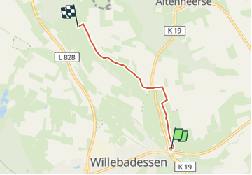
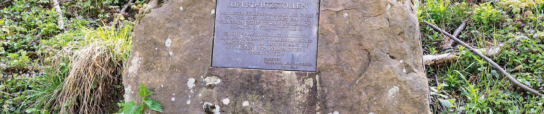
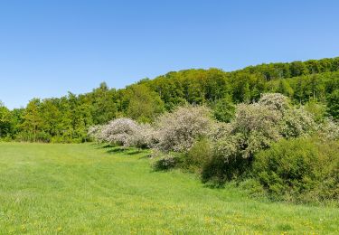
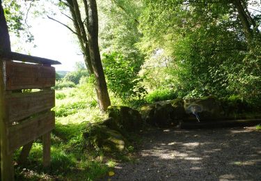
Trail On foot of 3.2 km to be discovered at North Rhine-Westphalia, Kreis Höxter, Willebadessen. This trail is proposed by SityTrail - itinéraires balisés pédestres.
Description
Trail created by Zweckverband Naturpark Teutoburger Wald / Eggegebirge, Detmold.
Symbol: green leaf on a black stem
Positioning
Country:
Germany
Region :
North Rhine-Westphalia
Department/Province :
Kreis Höxter
Municipality :
Willebadessen
Location:
Unknown
Start:(Dec)
Start:(UTM)
503092 ; 5719616 (32U) N.
Comments
Trails nearby
![Trail On foot Willebadessen - Hitgenheierweg (Willebadessen) - Photo](https://media.geolcdn.com/t/375/260/0f673616-b441-4982-8531-e7d24287f826.jpeg&format=jpg&maxdim=2)
![On foot On foot](https://static1.geolcdn.com/sitytour/trail-icons/100.png)
Hitgenheierweg (Willebadessen)
On foot
Easy
Willebadessen,
North Rhine-Westphalia,
Kreis Höxter,
Germany
![](/images/other/stat-length.png)
12.4 km | 15.8 km-effort
3h 35min
![](https://static1.geolcdn.com/siteimages/upload/files/16400158638029165_repeat_loop_refresh_sync_direction_icon.png)
Yes
![Trail On foot Willebadessen - Alte Eisenbahn Rundweg A3 - Photo](https://media.geolcdn.com/t/375/260/8e1b92af-1267-457b-97f8-a4e1ca714322.jpeg&format=jpg&maxdim=2)
![On foot On foot](https://static1.geolcdn.com/sitytour/trail-icons/100.png)
Alte Eisenbahn Rundweg A3
On foot
Easy
Willebadessen,
North Rhine-Westphalia,
Kreis Höxter,
Germany
![](/images/other/stat-length.png)
4.7 km | 6.6 km-effort
1h 30min
![](https://static1.geolcdn.com/siteimages/upload/files/16400158638029165_repeat_loop_refresh_sync_direction_icon.png)
Yes
![Trail On foot Willebadessen - Willebadessen Rundweg A7 - Photo](https://media.geolcdn.com/t/375/260/7a247ba7-8339-48af-9b93-714c4841fe3f.jpeg&format=jpg&maxdim=2)
![On foot On foot](https://static1.geolcdn.com/sitytour/trail-icons/100.png)
Willebadessen Rundweg A7
On foot
Easy
Willebadessen,
North Rhine-Westphalia,
Kreis Höxter,
Germany
![](/images/other/stat-length.png)
5.4 km | 6.9 km-effort
1h 33min
![](https://static1.geolcdn.com/siteimages/upload/files/16400158638029165_repeat_loop_refresh_sync_direction_icon.png)
No
![Trail On foot Willebadessen - Rundwanderweg](https://media.geolcdn.com/t/375/260/8e1b92af-1267-457b-97f8-a4e1ca714322.jpeg&format=jpg&maxdim=2)
![On foot On foot](https://static1.geolcdn.com/sitytour/trail-icons/100.png)
Rundwanderweg "Alte Eisenbahn" A2
On foot
Easy
Willebadessen,
North Rhine-Westphalia,
Kreis Höxter,
Germany
![](/images/other/stat-length.png)
5 km | 6.6 km-effort
1h 30min
![](https://static1.geolcdn.com/siteimages/upload/files/16400158638029165_repeat_loop_refresh_sync_direction_icon.png)
Yes
![Trail On foot Willebadessen - Rundwanderweg](https://media.geolcdn.com/t/375/260/66b67238-4c60-45b4-8e3e-322939f68292.jpeg&format=jpg&maxdim=2)
![On foot On foot](https://static1.geolcdn.com/sitytour/trail-icons/100.png)
Rundwanderweg "Alte Eisenbahn" A1
On foot
Easy
Willebadessen,
North Rhine-Westphalia,
Kreis Höxter,
Germany
![](/images/other/stat-length.png)
4.4 km | 5.4 km-effort
1h 13min
![](https://static1.geolcdn.com/siteimages/upload/files/16400158638029165_repeat_loop_refresh_sync_direction_icon.png)
Yes
![Trail On foot Willebadessen - Rundwanderweg Wildgehege Willebadessen A2 (Willebadessen: Wildgehege Willebadessen) - Photo](https://media.geolcdn.com/t/375/260/a0354fae-5cdc-4f7b-b722-1535fe489c51.jpeg&format=jpg&maxdim=2)
![On foot On foot](https://static1.geolcdn.com/sitytour/trail-icons/100.png)
Rundwanderweg Wildgehege Willebadessen A2 (Willebadessen: Wildgehege Willebad...
On foot
Easy
Willebadessen,
North Rhine-Westphalia,
Kreis Höxter,
Germany
![](/images/other/stat-length.png)
7.9 km | 9.6 km-effort
2h 11min
![](https://static1.geolcdn.com/siteimages/upload/files/16400158638029165_repeat_loop_refresh_sync_direction_icon.png)
Yes
![Trail On foot Bad Driburg - Bollberg Rundweg A3 - Photo](https://media.geolcdn.com/t/375/260/3874e353-2ee8-471c-8025-65d7294cf883.jpeg&format=jpg&maxdim=2)
![On foot On foot](https://static1.geolcdn.com/sitytour/trail-icons/100.png)
Bollberg Rundweg A3
On foot
Easy
Bad Driburg,
North Rhine-Westphalia,
Kreis Höxter,
Germany
![](/images/other/stat-length.png)
3.2 km | 4.1 km-effort
56min
![](https://static1.geolcdn.com/siteimages/upload/files/16400158638029165_repeat_loop_refresh_sync_direction_icon.png)
Yes
![Trail On foot Willebadessen - Willebadessen Route 5 - Photo](https://media.geolcdn.com/t/375/260/7a247ba7-8339-48af-9b93-714c4841fe3f.jpeg&format=jpg&maxdim=2)
![On foot On foot](https://static1.geolcdn.com/sitytour/trail-icons/100.png)
Willebadessen Route 5
On foot
Easy
Willebadessen,
North Rhine-Westphalia,
Kreis Höxter,
Germany
![](/images/other/stat-length.png)
3.4 km | 4.1 km-effort
55min
![](https://static1.geolcdn.com/siteimages/upload/files/16400158638029165_repeat_loop_refresh_sync_direction_icon.png)
No
![Trail On foot Willebadessen - Willebadessen Route 4 - Photo](https://media.geolcdn.com/t/375/260/ac4580d5-5d7b-4fa0-96e5-ef3ac2fef5d8.jpeg&format=jpg&maxdim=2)
![On foot On foot](https://static1.geolcdn.com/sitytour/trail-icons/100.png)
Willebadessen Route 4
On foot
Easy
Willebadessen,
North Rhine-Westphalia,
Kreis Höxter,
Germany
![](/images/other/stat-length.png)
6.6 km | 8.4 km-effort
1h 54min
![](https://static1.geolcdn.com/siteimages/upload/files/16400158638029165_repeat_loop_refresh_sync_direction_icon.png)
No