Trail  Saint-Gervais-les-Bains - 2021-06-12_23h10m48_tmb-jour-1-x-les-houches-x-telepherique-x-bivouac- - Photo

2021-06-12_23h10m48_tmb-jour-1-x-les-houches-x-telepherique-x-bivouac-

© OpenStreetMap contributors
Length
Length
17.6 km
Max alt
Max alt
2117 m
Uphill gradient
Uphill gradient
1397 m
Km-Effort
Km-Effort  
37 km
Min alt
Min alt
1339 m
Downhill gradient
Downhill gradient
1662 m
Boucle
Boucle
No
Creation date :
2021-06-12 21:10:48.881
Updated on :
2021-06-12 21:10:50.235

(0 Reviews)


Scan this QR Code to open this trail in the SityTrail application

FREE GPS app for hiking

Logo SityTrail SityTrail

IGN / Geographical institutes

Download SityTrail from the App Store Download SityTrail from Google Play

Logo SityTrail SityTrail World

The world is yours!

Download SityTrail from the App Store Download SityTrail from Google Play Download SityTrail on Huawei AppGallery

About

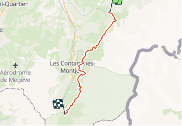
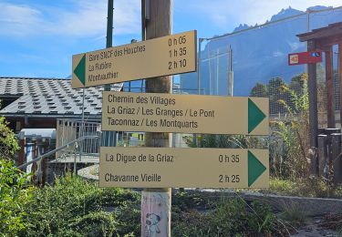
Trail of 17.6 km to be discovered at Auvergne-Rhône-Alpes, Upper Savoy, Saint-Gervais-les-Bains. This trail is proposed by AnthonyLeguedois.

Description

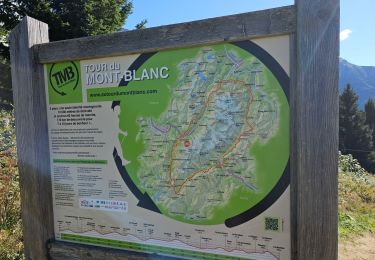
Les houches --> Nant borand par GR5 : 19km 1100 D
Les houches --> Nant borand par GRP : 22km 1900 D

Elevation profile

Positioning

Country:
France
Region :
Auvergne-Rhône-Alpes
Department/Province :
Upper Savoy
Municipality :
Saint-Gervais-les-Bains
Location:
Unknown
Start:(UTM)
327665 ; 5082448 (32T) N.

Trails nearby

Trail Walking Les Houches - 2024-05-29_17h11m02_christ-roi - Photo
Walking
GUIDE
mumu.larandonneuse

Walking

Easy
(1)
Les Houches, Auvergne-Rhône-Alpes, Upper Savoy, France
1.8 km | 4.2 km-effort
56min
No
Trail Walking Chamonix-Mont-Blanc - Glacier des Bossons Les Houches Chamonix - Photo
Walking
tracegps

Walking

Difficult
(2)
Chamonix-Mont-Blanc, Auvergne-Rhône-Alpes, Upper Savoy, France
13.1 km | 28 km-effort
5h 0min
Yes
Trail Walking Les Houches - Chalets de Charlousse - Photo
Walking
YannPro81

Walking

Easy
(2)
Les Houches, Auvergne-Rhône-Alpes, Upper Savoy, France
9.2 km | 14.1 km-effort
2h 28min
Yes
Trail Walking Saint-Gervais-les-Bains - Descente au Glacier de Bionnassay depuis le Nid d''Aigle - Photo
Walking
GUIDE
pscheven

Walking

Very easy
(1)
Saint-Gervais-les-Bains, Auvergne-Rhône-Alpes, Upper Savoy, France
839 m | 1.9 km-effort
28min
No
Trail Walking Les Houches - J14 - R13 - La statue du Christ Roi - Photo
Walking
GUIDE
mumu.larandonneuse

Walking

Medium
Les Houches, Auvergne-Rhône-Alpes, Upper Savoy, France
2.3 km | 5.2 km-effort
56min
Yes
Trail Walking Saint-Gervais-les-Bains - tour du vorassay 1000m 14kms  - Photo
Walking
GUIDE
Danielba

Walking

Medium
Saint-Gervais-les-Bains, Auvergne-Rhône-Alpes, Upper Savoy, France
13.4 km | 27 km-effort
6h 40min
Yes
Trail Walking Les Houches - boucle aiguillette des houches ,refuge bel-lachat - Photo
Walking
carton-fils@orange.fr

Walking

Very difficult
Les Houches, Auvergne-Rhône-Alpes, Upper Savoy, France
10.4 km | 24 km-effort
2h 49min
Yes
Trail Walking Les Houches - échec refuge de bellachat - Photo
Walking
carton-fils@orange.fr

Walking

Medium
Les Houches, Auvergne-Rhône-Alpes, Upper Savoy, France
3.9 km | 8.1 km-effort
2h 38min
Yes
Trail Walking Les Houches - Parc Animalier Merlet - Chalets de Chailloux - Aiguillettes des Houches - Photo
Walking
LtZIP

Walking

Difficult
Les Houches, Auvergne-Rhône-Alpes, Upper Savoy, France
11 km | 23 km-effort
5h 17min
Yes


Close
My subscriptions