Trail Trail Valbelle - t16321 TraceGps issued - Photo
 phd04
phd04

User

© OpenStreetMap contributors
Length
Length
17.4 km
Max alt
Max alt
1434 m
Uphill gradient
Uphill gradient
940 m
Km-Effort
Km-Effort  
30 km
Min alt
Min alt
572 m
Downhill gradient
Downhill gradient
943 m
Boucle
Boucle
Yes
Creation date :
2021-05-15 14:10:09.07
Updated on :
2021-05-15 14:45:10.223

(0 Reviews)

Trail
Trail
2h30
Difficulty : Difficult

Scan this QR Code to open this trail in the SityTrail application

FREE GPS app for hiking

Logo SityTrail SityTrail

IGN / Geographical institutes

Download SityTrail from the App Store Download SityTrail from Google Play

Logo SityTrail SityTrail World

The world is yours!

Download SityTrail from the App Store Download SityTrail from Google Play Download SityTrail on Huawei AppGallery

About

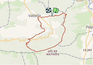
Trail Trail of 17.4 km to be discovered at Provence-Alpes-Côte d'Azur, Alpes-de-Haute-Provence, Valbelle. This trail is proposed by phd04.

Description

Randonnée Trail de 17 km à découvrir à VALBELLE, ALPES-DE-HAUTE-PROVENCE, PROVENCE-ALPES-COTE D'AZUR. Cette randonnée est proposée par phd04.

De Valbelle prendre la direction du Pas de Peipin par les Escoffiers. Suivre le PR (jaune) jusqu'au Pas de Peipin. Prendre à droite direction Pas de Jean Richaud. Vous suivrez la ligne de crête avec une vue imprenable à 360°. Une fois au Pas de Jean Richaud (1441 m) prendre sur la droite le GR de Pays jusqu'à l'aire St Robert. Suivre ensuite, le GR6 qui vous redescendra jusqu'à Valbelle.( à voir Chapelle St Honoré).

Elevation profile

Photos

Positioning

Country:
France
Region :
Provence-Alpes-Côte d'Azur
Department/Province :
Alpes-de-Haute-Provence
Municipality :
Valbelle
Location:
Unknown
Start:(UTM)
732372 ; 4892311 (31T) N.

Trails nearby

Trail Walking Peipin - PEIPIN . PAR LES CHEMINS ABANDONNÉS DE PEIPIN  O L S  - Photo
Walking
GUIDE
RobinMicheline

Walking

Medium
(1)
Peipin, Provence-Alpes-Côte d'Azur, Alpes-de-Haute-Provence, France
9 km | 17.7 km-effort
2h 46min
Yes
Trail Walking Aubignosc - AUBIGNOSC.  Vieil Chateau Neuf  , canyons o l m s - Photo
Walking
GUIDE
RobinMicheline

Walking

Easy
(1)
Aubignosc, Provence-Alpes-Côte d'Azur, Alpes-de-Haute-Provence, France
12.6 km | 17.6 km-effort
3h 33min
Yes
Trail Walking Aubignosc - AUBIGNOSC . LE PETIT COLORADO . O L S - Photo
Walking
GUIDE
RobinMicheline

Walking

Medium
(1)
Aubignosc, Provence-Alpes-Côte d'Azur, Alpes-de-Haute-Provence, France
8.3 km | 11.3 km-effort
2h 36min
Yes
Trail Walking Valbelle - VALBELLE . Chemin de Sara o l s - Photo
Walking
GUIDE
RobinMicheline

Walking

Medium
(1)
Valbelle, Provence-Alpes-Côte d'Azur, Alpes-de-Haute-Provence, France
13.2 km | 19.7 km-effort
4h 47min
Yes
Trail Walking Peipin - PEIPIN . aubignosc. Le vieux village Château Neuf Val Saint Donnât par GR7  o  53D - Photo
Walking
GUIDE
RobinMicheline

Walking

Easy
(1)
Peipin, Provence-Alpes-Côte d'Azur, Alpes-de-Haute-Provence, France
13.5 km | 18.3 km-effort
3h 44min
Yes
Trail Walking Valbelle - 05 chap st Pons col sumiou zel - Photo
Walking
GUIDE
randodyssée

Walking

Difficult
Valbelle, Provence-Alpes-Côte d'Azur, Alpes-de-Haute-Provence, France
11 km | 21 km-effort
5h 40min
Yes
Trail Walking Valbelle - 04 chapelle St Pons 03.08.23 - Photo
Walking
GUIDE
randodyssée

Walking

Difficult
Valbelle, Provence-Alpes-Côte d'Azur, Alpes-de-Haute-Provence, France
8.2 km | 13.6 km-effort
3h 27min
No
Trail Walking Sisteron - BEVONS    crêtes de Chapage o l s m - Photo
Walking
GUIDE
RobinMicheline

Walking

Medium
Sisteron, Provence-Alpes-Côte d'Azur, Alpes-de-Haute-Provence, France
8.2 km | 15 km-effort
2h 37min
Yes
Trail On foot Valbelle - Montagne de Lure - Photo
On foot
GUIDE
Marco05

On foot

Difficult
Valbelle, Provence-Alpes-Côte d'Azur, Alpes-de-Haute-Provence, France
20 km | 35 km-effort
7h 54min
Yes


Close
My subscriptions