![](/images/other/stat-length.png)
![Trail Walking Le Castellard-Mélan - Boucle 3,7 km au départ de Fontbarliere par Manent et les Collons - Photo](https://media.geolcdn.com/t/1900/400/85e2e78c-2611-490f-8e52-193a05db09d4.jpg&format=pjpeg&maxdim=2)
Boucle 3,7 km au départ de Fontbarliere par Manent et les Collons
jalien04
User
![Length](/images/other/stat-length.png)
![Max alt](https://static1.geolcdn.com/siteimages/upload/files/1508320355ic_sort_altitude_max_24dp.png)
![Uphill gradient](https://static1.geolcdn.com/siteimages/upload/files/1508320355ic_sort_den_pos_24dp.png)
![Km-Effort](/images/other/stat-length.png)
![Min alt](https://static1.geolcdn.com/siteimages/upload/files/1508320355ic_sort_altitude_min_24dp.png)
![Downhill gradient](https://static1.geolcdn.com/siteimages/upload/files/1508320355ic_sort_den_neg_24dp.png)
![Boucle](https://static1.geolcdn.com/siteimages/upload/files/16400158638029165_repeat_loop_refresh_sync_direction_icon.png)
![Walking](https://static1.geolcdn.com/sitytour/trail-icons/101.png)
1h10
Difficulty : Very easy
![Trail](https://static1.geolcdn.com/sitytour/trail-icons/104.png)
--
Difficulty : Very easy
![Mountain bike](https://static1.geolcdn.com/sitytour/trail-icons/202.png)
25m
Difficulty : Easy
![Horseback riding](https://static1.geolcdn.com/sitytour/trail-icons/301.png)
48m
Difficulty : Easy
![Scan this QR Code to open this trail in the SityTrail application](https://capi.geolives.com/qq0zvz2zws4bq2lad0pu/sitytour/trails/2668244/qr.png?size=200)
FREE GPS app for hiking
About
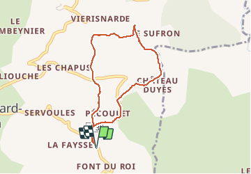
Trail Walking of 3.7 km to be discovered at Provence-Alpes-Côte d'Azur, Alpes-de-Haute-Provence, Le Castellard-Mélan. This trail is proposed by jalien04.
Description
Départ Fontbarlière, route RD3, point kilométrique 19,700, entre Thoard à 4 km et le col de Fontbelle à 7 km.
Avant de bifurquer sur la droite vers Château-Duyes et Manent, 500 m de route goudronnée RD3 montante, suivre ensuite deux panneaux Mélan à 1,5 km et à 2 km, en cours de montée à 2,3 km, au niveau d’un regard de contrôle du réseau d’eau sur le talus en face, prendre à gauche en descendant, longer le hameau des Colons, traverser la RD3 et emprunter le chemin public descendant (panneau) jusqu’à la borne incendie n°2, puis 200 m de RD3 vers l’aval pour rejoindre le point de départ.
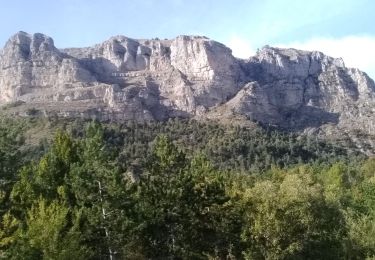
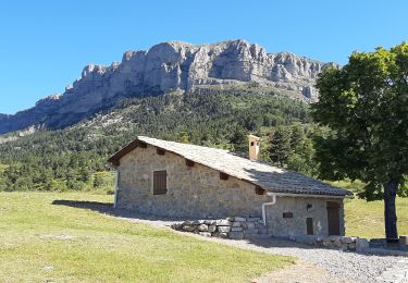
La vue est dégagée sur la majorité du parcours parmi des paturâges et des prairies avec vue sur la barre de Géruen, le massif du Blayeul et la vallée des Duyes.
Photos fléchées sur https://haut-pays-provencal.com/boucle-randonnee-37km-depart-fontbarliere
Positioning
Comments
Trails nearby
![Trail Walking Saint-Geniez - S GENIEZ . ABROS . LA FOREST . COL DE MOUNIS . O L M - Photo](https://media.geolcdn.com/t/375/260/fe9f057e-508d-4bc4-89fa-aff1c37055dd.jpg&format=jpg&maxdim=2)
![Walking Walking](https://static1.geolcdn.com/sitytour/trail-icons/101.png)
Walking
![](/images/other/stat-length.png)
![](https://static1.geolcdn.com/siteimages/upload/files/16400158638029165_repeat_loop_refresh_sync_direction_icon.png)
![Trail Walking Hautes-Duyes - geruen sentier des chamois - Photo](https://media.geolcdn.com/t/375/260/76e6f18d-9f19-4351-821e-ec84b6202ed5.jpg&format=jpg&maxdim=2)
![Walking Walking](https://static1.geolcdn.com/sitytour/trail-icons/101.png)
Walking
![](/images/other/stat-length.png)
![](https://static1.geolcdn.com/siteimages/upload/files/16400158638029165_repeat_loop_refresh_sync_direction_icon.png)
![Trail Walking Le Castellard-Mélan - MELAN . Col de Mounis , sommet du Corbeau o l s - Photo](https://media.geolcdn.com/t/375/260/2b656901-381a-4dfe-a9e9-2df9166addba.jpg&format=jpg&maxdim=2)
![Walking Walking](https://static1.geolcdn.com/sitytour/trail-icons/101.png)
Walking
![](/images/other/stat-length.png)
![](https://static1.geolcdn.com/siteimages/upload/files/16400158638029165_repeat_loop_refresh_sync_direction_icon.png)
![Trail Walking Thoard - la Bigue par Thoard - Photo](https://media.geolcdn.com/t/375/260/ext.jpg?maxdim=2&url=https%3A%2F%2Fservices.sitytrail.com%2FGeolivesWS%2FDownloadMedia.ashx%3FTrailID%3D403749%26Media%3Dfix__20150404143536.jpg)
![Walking Walking](https://static1.geolcdn.com/sitytour/trail-icons/101.png)
Walking
![](/images/other/stat-length.png)
![](https://static1.geolcdn.com/siteimages/upload/files/16400158638029165_repeat_loop_refresh_sync_direction_icon.png)
![Trail Walking Le Castellard-Mélan - Autour de Fontbelle 18/12/2024 - Photo](https://media.geolcdn.com/t/375/260/69b9121f-8e6a-46ef-affd-f6d0486b57b2.jpg&format=jpg&maxdim=2)
![Walking Walking](https://static1.geolcdn.com/sitytour/trail-icons/101.png)
Walking
![](/images/other/stat-length.png)
![](https://static1.geolcdn.com/siteimages/upload/files/16400158638029165_repeat_loop_refresh_sync_direction_icon.png)
![Trail Walking Hautes-Duyes - Crête de Géruën descente sud Est - Photo](https://media.geolcdn.com/t/375/260/896db46e-982b-48f6-bf8f-c5ab98c282d0.jpg&format=jpg&maxdim=2)
![Walking Walking](https://static1.geolcdn.com/sitytour/trail-icons/101.png)
Walking
![](/images/other/stat-length.png)
![](https://static1.geolcdn.com/siteimages/upload/files/16400158638029165_repeat_loop_refresh_sync_direction_icon.png)
![Trail Walking Hautes-Duyes - sommet Geruen et son pas - Photo](https://media.geolcdn.com/t/375/260/3f9beb02-93ed-438f-917d-d2a6ab1524ae.jpg&format=jpg&maxdim=2)
![Walking Walking](https://static1.geolcdn.com/sitytour/trail-icons/101.png)
Walking
![](/images/other/stat-length.png)
![](https://static1.geolcdn.com/siteimages/upload/files/16400158638029165_repeat_loop_refresh_sync_direction_icon.png)
![Trail Walking Le Castellard-Mélan - AUTHON Fontbelle, piste forestière du Pras au pied de Gueruen, col d Ainac AR o l s - Photo](https://media.geolcdn.com/t/375/260/dec138bf-804c-4cb4-847d-e62046dced38.jpg&format=jpg&maxdim=2)
![Walking Walking](https://static1.geolcdn.com/sitytour/trail-icons/101.png)
Walking
![](/images/other/stat-length.png)
![](https://static1.geolcdn.com/siteimages/upload/files/16400158638029165_repeat_loop_refresh_sync_direction_icon.png)
![Trail Walking Le Castellard-Mélan - AUTHON .Fontbelle . Crete de Gueruen AR l s o - Photo](https://media.geolcdn.com/t/375/260/8514d4db-f5aa-4def-8a98-d1c8bfa5b730.jpg&format=jpg&maxdim=2)
![Walking Walking](https://static1.geolcdn.com/sitytour/trail-icons/101.png)
Walking
![](/images/other/stat-length.png)
![](https://static1.geolcdn.com/siteimages/upload/files/16400158638029165_repeat_loop_refresh_sync_direction_icon.png)