Trail Walking Ceillac - Queyras Ceill1c Lac St Anne - Photo
 Nad38
Nad38

User

© OpenStreetMap contributors
Length
Length
15.6 km
Max alt
Max alt
2416 m
Uphill gradient
Uphill gradient
805 m
Km-Effort
Km-Effort  
27 km
Min alt
Min alt
1632 m
Downhill gradient
Downhill gradient
859 m
Boucle
Boucle
No
Creation date :
2020-07-19 08:04:18.957
Updated on :
2020-07-19 14:34:41.011

(0 Reviews)

Walking
Walking
6h02
Difficulty : Difficult

Scan this QR Code to open this trail in the SityTrail application

FREE GPS app for hiking

Logo SityTrail SityTrail

IGN / Geographical institutes

Download SityTrail from the App Store Download SityTrail from Google Play

Logo SityTrail SityTrail World

The world is yours!

Download SityTrail from the App Store Download SityTrail from Google Play Download SityTrail on Huawei AppGallery

About

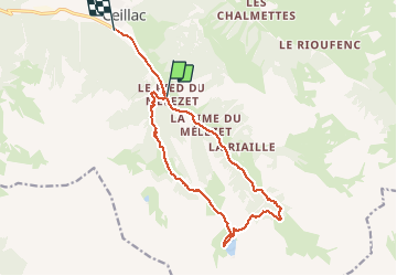
Trail Walking of 15.6 km to be discovered at Provence-Alpes-Côte d'Azur, Hautes-Alpes, Ceillac. This trail is proposed by Nad38.

Description

un peu raide jusqu'auLac du miroir mais très belle ballade

Elevation profile

Photos

Positioning

Country:
France
Region :
Provence-Alpes-Côte d'Azur
Department/Province :
Hautes-Alpes
Municipality :
Ceillac
Location:
Unknown
Start:(UTM)
324882 ; 4946455 (32T) N.

Trails nearby

Trail Walking Ceillac - Crêtes de Chambrettes - Photo
Walking
GUIDE
amiral13

Walking

Medium
(1)
Ceillac, Provence-Alpes-Côte d'Azur, Hautes-Alpes, France
13.4 km | 26 km-effort
5h 53min
Yes
Trail Walking Ceillac - 05 Tour Font Sancte - étape 1 - Photo
Walking
Maryma

Walking

Very difficult
(1)
Ceillac, Provence-Alpes-Côte d'Azur, Hautes-Alpes, France
16.5 km | 36 km-effort
8h 9min
No
Trail Walking Ceillac - Col Girardin - Photo
Walking
GUIDE
Marco05

Walking

Very difficult
Ceillac, Provence-Alpes-Côte d'Azur, Hautes-Alpes, France
14.5 km | 29 km-effort
6h 32min
Yes
Trail Walking Ceillac - Queyras_lac de Clausis - Photo
Walking
MartinBraudThierry

Walking

Very easy
(1)
Ceillac, Provence-Alpes-Côte d'Azur, Hautes-Alpes, France
13.1 km | 26 km-effort
2h 59min
Yes
Trail Walking Ceillac - Ceillac - St Véran - Photo
Walking
GUIDE
romanceline

Walking

Medium
Ceillac, Provence-Alpes-Côte d'Azur, Hautes-Alpes, France
13.5 km | 28 km-effort
7h 22min
No
Trail Other activity Ceillac - Col de la petite Par. Col Girardin  - Photo
Other activity
GUIDE
nadd73

Other activity

Difficult
Ceillac, Provence-Alpes-Côte d'Azur, Hautes-Alpes, France
13.9 km | 32 km-effort
7h 36min
Yes
Trail Walking Ceillac - le Longet ou tête du Rissace - Photo
Walking
GUIDE
amiral13

Walking

Medium
Ceillac, Provence-Alpes-Côte d'Azur, Hautes-Alpes, France
13 km | 25 km-effort
6h 26min
Yes
Trail Walking Ceillac - la pointe de la Saume (traversée) - Photo
Walking
GUIDE
amiral13

Walking

Difficult
Ceillac, Provence-Alpes-Côte d'Azur, Hautes-Alpes, France
15 km | 34 km-effort
6h 43min
No
Trail Walking Ceillac - Lac Ste Anne et Tête de Girardin - Photo
Walking
GUIDE
amiral13

Walking

Medium
Ceillac, Provence-Alpes-Côte d'Azur, Hautes-Alpes, France
14.4 km | 27 km-effort
5h 48min
Yes


Close
My subscriptions