![](/images/other/stat-length.png)
![Trail Walking Abondance - crête des fours - Photo](https://media.geolcdn.com/t/1900/400/c5c2ba4c-8a14-4a72-ae3f-0e0862cb84dd.jpg&format=pjpeg&maxdim=2)
crête des fours
GuyVachet
User
![Length](/images/other/stat-length.png)
![Max alt](https://static1.geolcdn.com/siteimages/upload/files/1508320355ic_sort_altitude_max_24dp.png)
![Uphill gradient](https://static1.geolcdn.com/siteimages/upload/files/1508320355ic_sort_den_pos_24dp.png)
![Km-Effort](/images/other/stat-length.png)
![Min alt](https://static1.geolcdn.com/siteimages/upload/files/1508320355ic_sort_altitude_min_24dp.png)
![Downhill gradient](https://static1.geolcdn.com/siteimages/upload/files/1508320355ic_sort_den_neg_24dp.png)
![Boucle](https://static1.geolcdn.com/siteimages/upload/files/16400158638029165_repeat_loop_refresh_sync_direction_icon.png)
![Walking](https://static1.geolcdn.com/sitytour/trail-icons/101.png)
4h07
Difficulty : Medium
![Scan this QR Code to open this trail in the SityTrail application](https://capi.geolives.com/qq0zvz2zws4bq2lad0pu/sitytour/trails/2123663/qr.png?size=200)
FREE GPS app for hiking
About
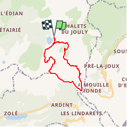
Trail Walking of 11.7 km to be discovered at Auvergne-Rhône-Alpes, Upper Savoy, Abondance. This trail is proposed by GuyVachet.
Description
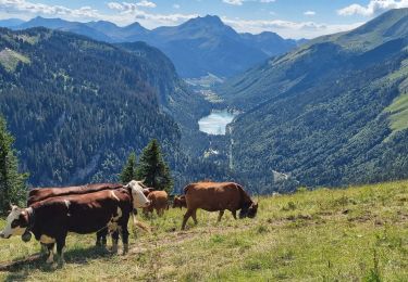
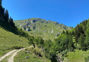
Crêtes des fours à partir du lac des Plagnes en passant par le col de l'Aup Couti. Le parcours est en grande partie en forêt (idéal en cas de canicule) pratiquement jusqu'aux chalets de Lens. Au-dessus du lac, on trouve rapidement la zone humide de Cubouré qui fut un lac alimenté par le glacier d'Ardens, il y a plus de 15000 ans ( voir panneau explicatif) et l'itinéraire devient sentier pour monter au refuge des Tinderets (sentier de découverte). Continuer à monter en direction des chalets de Lens et obliquer à droite au panneau qui annonce le col de l'Aup Couti (1812m) avec une belle vue sur la Pointe de la Chavache (presque 2100m). Encore un petit effort pour atteindre la Pointe des Landes (1844m, point haut de la randonnée qui domine les chalets de Mens). Là le sentier devient un peu aérien sans être toutefois vertigineux (voir photo) puis la descente continue sous couvert jusqu'au Col de Bassachaux et aux Chalets de Lens. Retour sur une route empierrée à découvert offrant une très belle vue sur le Mont Grange au pied duquel sont nichés les chalets du Jouly.
Positioning
Comments
Trails nearby
![Trail Walking Châtel - Mont de grange depuis le col de Bassachaux - Photo](https://media.geolcdn.com/t/375/260/ext.jpg?maxdim=2&url=https%3A%2F%2Fservices.sitytrail.com%2FGeolivesWS%2FDownloadMedia.ashx%3FTrailID%3D306971%26Media%3Dfix__20140529130822.jpg)
![Walking Walking](https://static1.geolcdn.com/sitytour/trail-icons/101.png)
Walking
![](/images/other/stat-length.png)
![](https://static1.geolcdn.com/siteimages/upload/files/16400158638029165_repeat_loop_refresh_sync_direction_icon.png)
![Trail Walking Abondance - Le Roc de Tavaneuse 2156 m, depuis Prétairié - Photo](https://media.geolcdn.com/t/375/260/ext.jpg?maxdim=2&url=https%3A%2F%2Fservices.sitytrail.com%2FGeolivesWS%2FDownloadMedia.ashx%3FTrailID%3D215188%26Media%3D15788_1.jpg)
![Walking Walking](https://static1.geolcdn.com/sitytour/trail-icons/101.png)
Walking
![](/images/other/stat-length.png)
![](https://static1.geolcdn.com/siteimages/upload/files/16400158638029165_repeat_loop_refresh_sync_direction_icon.png)
![Trail Walking Abondance - Le Mont de Grange, 2432m - Photo](https://media.geolcdn.com/t/375/260/ext.jpg?maxdim=2&url=https%3A%2F%2Fservices.sitytrail.com%2FGeolivesWS%2FDownloadMedia.ashx%3FTrailID%3D172598%26Media%3D13962_1.jpg)
![Walking Walking](https://static1.geolcdn.com/sitytour/trail-icons/101.png)
Walking
![](/images/other/stat-length.png)
![](https://static1.geolcdn.com/siteimages/upload/files/16400158638029165_repeat_loop_refresh_sync_direction_icon.png)
![Trail Walking La Chapelle-d'Abondance - Cascade boucle 2 - Photo](https://media.geolcdn.com/t/375/260/ext.jpg?maxdim=2&url=https%3A%2F%2Fstatic1.geolcdn.com%2Fsiteimages%2Fupload%2Ffiles%2F1553511878bg_sport_marche.png)
![Walking Walking](https://static1.geolcdn.com/sitytour/trail-icons/101.png)
Walking
![](/images/other/stat-length.png)
![](https://static1.geolcdn.com/siteimages/upload/files/16400158638029165_repeat_loop_refresh_sync_direction_icon.png)
![Trail Walking Montriond - Lac de Montrion, cascade d’Argent - Photo](https://media.geolcdn.com/t/375/260/0f3e12d5-8a74-4c57-96c0-8c76c4f7d90d.jpg&format=jpg&maxdim=2)
![Walking Walking](https://static1.geolcdn.com/sitytour/trail-icons/101.png)
Walking
![](/images/other/stat-length.png)
![](https://static1.geolcdn.com/siteimages/upload/files/16400158638029165_repeat_loop_refresh_sync_direction_icon.png)
![Trail Walking Abondance - Col de Bassachaux le lac vert 7 juillet 2022 - Photo](https://media.geolcdn.com/t/375/260/6bdd057f-20dc-4f51-87e3-ee4bf24e76cf.jpg&format=jpg&maxdim=2)
![Walking Walking](https://static1.geolcdn.com/sitytour/trail-icons/101.png)
Walking
![](/images/other/stat-length.png)
![](https://static1.geolcdn.com/siteimages/upload/files/16400158638029165_repeat_loop_refresh_sync_direction_icon.png)
![Trail On foot Abondance - Itineraire des bords de Dranse - Photo](https://media.geolcdn.com/t/375/260/a568e95b-20df-404f-9d88-44c6bb986db2.jpeg&format=jpg&maxdim=2)
![On foot On foot](https://static1.geolcdn.com/sitytour/trail-icons/100.png)
On foot
![](/images/other/stat-length.png)
![](https://static1.geolcdn.com/siteimages/upload/files/16400158638029165_repeat_loop_refresh_sync_direction_icon.png)
![Trail Walking Châtel - Les Mattes - Photo](https://media.geolcdn.com/t/375/260/98db01ae-d3f3-470a-a229-cdc13a6d9134.jpg&format=jpg&maxdim=2)
![Walking Walking](https://static1.geolcdn.com/sitytour/trail-icons/101.png)
Walking
![](/images/other/stat-length.png)
![](https://static1.geolcdn.com/siteimages/upload/files/16400158638029165_repeat_loop_refresh_sync_direction_icon.png)
![Trail Snowshoes Abondance - Les Carres - les Ouyes - le Chon - la Plagne - les Ogays - les Carres - raq - Photo](https://media.geolcdn.com/t/375/260/ext.jpg?maxdim=2&url=https%3A%2F%2Fservices.sitytrail.com%2FGeolivesWS%2FDownloadMedia.ashx%3FTrailID%3D897957%26Media%3D20180202132501.jpg)
![Snowshoes Snowshoes](https://static1.geolcdn.com/sitytour/trail-icons/504.png)
Snowshoes
![](/images/other/stat-length.png)
![](https://static1.geolcdn.com/siteimages/upload/files/16400158638029165_repeat_loop_refresh_sync_direction_icon.png)