Trail Walking Ceillac - Le Tour du Queyras (Ceillac - Saint Véran) - Photo

Le Tour du Queyras (Ceillac - Saint Véran)

 tracegps
tracegps

User

© OpenStreetMap contributors
Length
Length
12.5 km
Max alt
Max alt
2648 m
Uphill gradient
Uphill gradient
1183 m
Km-Effort
Km-Effort  
27 km
Min alt
Min alt
1638 m
Downhill gradient
Downhill gradient
804 m
Boucle
Boucle
No
Creation date :
2014-12-10 00:00:00.0
Updated on :
2014-12-10 00:00:00.0

(0 Reviews)

Walking
Walking
5h00
Difficulty : Difficult

Scan this QR Code to open this trail in the SityTrail application

FREE GPS app for hiking

Logo SityTrail SityTrail

IGN / Geographical institutes

Download SityTrail from the App Store Download SityTrail from Google Play

Logo SityTrail SityTrail World

The world is yours!

Download SityTrail from the App Store Download SityTrail from Google Play Download SityTrail on Huawei AppGallery

About

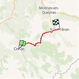
Trail Walking of 12.5 km to be discovered at Provence-Alpes-Côte d'Azur, Hautes-Alpes, Ceillac. This trail is proposed by tracegps.

Description

Etape 6: On quitte Ceillac vers le nord-est par la partie commune GR5-GR58, sur la route qui suit la vallée du Cristillan. 500 mètres environ après l’église on prend, à gauche, un sentier qui va au Villard en passant devant la chapelle Sainte Barbe. Au Villard on laisse le GR5 grimper au col Fromage et on continue vers l’est-sud-est pendant un peu moins de 2 kilomètres. C’est là qu’on attaque la montée vers le col des Estronques, 700 mètres plus haut, globalement vers le nord-est. Mais le panorama est un alibi parfait pour les nombreux arrêts photo qui permettent de souffler… ;-) La descente vers Saint Véran décrit un arc de cercle le long du rif de Lamaron, d’abord vers le nord, puis nord-est. Après avoir traversé, à leur confluence, les rifs de Lamaron, des Flottes et de Chatelard, on franchi l’Aigue Blanche au pont du Moulin. Et là on croit que c’est fini ; et bien non, il reste 200 mètres à grimper avant d’atteindre le hameau du Raux et enfin le très touristique Saint Véran. Mais ça vaut le coup !

Elevation profile

Photos

Positioning

Country:
France
Region :
Provence-Alpes-Côte d'Azur
Department/Province :
Hautes-Alpes
Municipality :
Ceillac
Location:
Unknown
Start:(UTM)
323714 ; 4948277 (32T) N.

Trails nearby

Trail Walking Ceillac - Crêtes de Chambrettes - Photo
Walking
GUIDE
amiral13

Walking

Medium
(1)
Ceillac, Provence-Alpes-Côte d'Azur, Hautes-Alpes, France
13.4 km | 26 km-effort
5h 53min
Yes
Trail Walking Ceillac - 05 Tour Font Sancte - étape 1 - Photo
Walking
Maryma

Walking

Very difficult
(1)
Ceillac, Provence-Alpes-Côte d'Azur, Hautes-Alpes, France
16.5 km | 36 km-effort
8h 9min
No
Trail Walking Vars - 05 Tour Font Sancte - étape 2 - Photo
Walking
Maryma

Walking

Very difficult
(1)
Vars, Provence-Alpes-Côte d'Azur, Hautes-Alpes, France
19 km | 38 km-effort
8h 41min
No
Trail Walking Ceillac - Col Girardin - Photo
Walking
GUIDE
Marco05

Walking

Very difficult
Ceillac, Provence-Alpes-Côte d'Azur, Hautes-Alpes, France
14.5 km | 29 km-effort
6h 32min
Yes
Trail Walking Ceillac - Ceillac - St Véran - Photo
Walking
GUIDE
romanceline

Walking

Medium
Ceillac, Provence-Alpes-Côte d'Azur, Hautes-Alpes, France
13.5 km | 28 km-effort
7h 22min
No
Trail Other activity Ceillac - Col de la petite Par. Col Girardin  - Photo
Other activity
GUIDE
nadd73

Other activity

Difficult
Ceillac, Provence-Alpes-Côte d'Azur, Hautes-Alpes, France
13.9 km | 32 km-effort
7h 36min
Yes
Trail Walking Ceillac - la pointe de la Saume (traversée) - Photo
Walking
GUIDE
amiral13

Walking

Difficult
Ceillac, Provence-Alpes-Côte d'Azur, Hautes-Alpes, France
15 km | 34 km-effort
6h 43min
No
Trail Walking Ceillac - Lac Ste Anne et Tête de Girardin - Photo
Walking
GUIDE
amiral13

Walking

Medium
Ceillac, Provence-Alpes-Côte d'Azur, Hautes-Alpes, France
14.4 km | 27 km-effort
5h 48min
Yes
Trail Walking Ceillac - lac Sainte Anne - Photo
Walking
griffet

Walking

Easy
(2)
Ceillac, Provence-Alpes-Côte d'Azur, Hautes-Alpes, France
10.7 km | 17.9 km-effort
5h 16min
No


Close
My subscriptions