![](/images/other/stat-length.png)
![Trail Walking Saint-Gervais-les-Bains - Balade dans le Val d'Arly - Le Mont Joly - Photo](https://media.geolcdn.com/t/1900/400/ext.pjpeg?maxdim=2&url=https%3A%2F%2Fservices.sitytrail.com%2FGeolivesWS%2FDownloadMedia.ashx%3FTrailID%3D108786%26Media%3D1954_6.jpg)
Balade dans le Val d'Arly - Le Mont Joly
tracegps
User
![Length](/images/other/stat-length.png)
![Max alt](https://static1.geolcdn.com/siteimages/upload/files/1508320355ic_sort_altitude_max_24dp.png)
![Uphill gradient](https://static1.geolcdn.com/siteimages/upload/files/1508320355ic_sort_den_pos_24dp.png)
![Km-Effort](/images/other/stat-length.png)
![Min alt](https://static1.geolcdn.com/siteimages/upload/files/1508320355ic_sort_altitude_min_24dp.png)
![Downhill gradient](https://static1.geolcdn.com/siteimages/upload/files/1508320355ic_sort_den_neg_24dp.png)
![Boucle](https://static1.geolcdn.com/siteimages/upload/files/16400158638029165_repeat_loop_refresh_sync_direction_icon.png)
![Walking](https://static1.geolcdn.com/sitytour/trail-icons/101.png)
5h00
Difficulty : Very difficult
![Scan this QR Code to open this trail in the SityTrail application](https://capi.geolives.com/qq0zvz2zws4bq2lad0pu/sitytour/trails/108786/qr.png?size=200)
FREE GPS app for hiking
About
Trail Walking of 5.3 km to be discovered at Auvergne-Rhône-Alpes, Upper Savoy, Saint-Gervais-les-Bains. This trail is proposed by tracegps.
Description
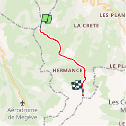
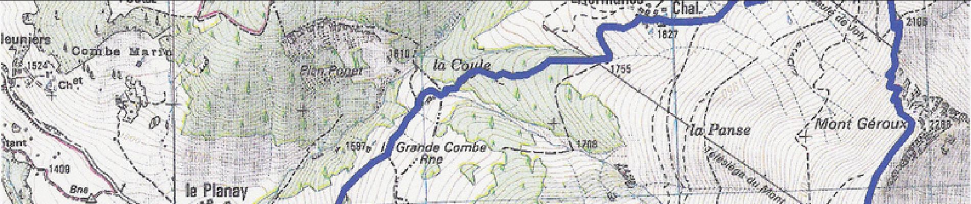
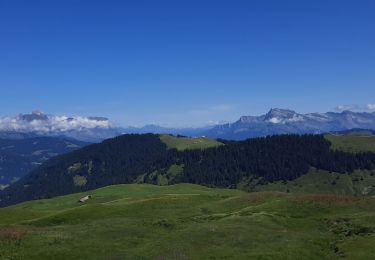
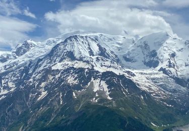
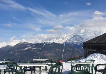
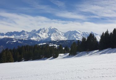
L’accès le plus aisé au mont Joly se fait depuis le mont d’Arbois en empruntant la télécabine à la montée puis à la descente. Hors période d’ouverture, il est préférable de monter par Hermance à partir du Planay. Accès au point de départ : Au centre de Megève, prendre la direction « Altiport – Cote 2000 ».Stationner 3 km après sur le parking de la télécabine du mont d’Arbois. Emprunter cette remontée mécanique. Itinéraire : Du sommet, partir vers le sud. Après une plate-forme, commencer à descendre tout droit. 300 m après, la piste remonte vers le mont d’Arbois. Au bout de 200 m, monter à gauche (facultatif) vers la croupe pour atteindre les tables d’orientation situées derrière le bâtiment. Continuer sur la crête et rejoindre la piste suivie toujours tout droit.. Dépasser l’hôtel-restaurant « Chez la Tante », traverser le mont Joux. Redescendre au col du Christ. Monter au chalet restaurant du mont Joly. 50 m après ce dernier, quitter la piste pour un sentier raide grimpant sur la crête. Du mont Géroux, on observe la masse rocheuse du mont Joly. Après le télésiège du mont Joly, le sentier s’élève sur son flanc ouest et devient déversent. Il oblique ensuite au nord-est pour rejoindre le sommet. On domine alors les Contamines-Montjoie et on admire le dôme du Goûter, l’aiguille de Bionnassay, le mont Blanc et, plus près, les dômes de Miage, le glacier d’Armancette et la superbe langue du glacier de Tré-la-Tête. Revenir par le même itinéraire jusqu’à la télécabine du mont d’Arbois. Altitude de départ : 1827 m Altitude d’arrivée : 2525 m
Positioning
Comments
Trails nearby
![Trail Mountain bike Megève - Megeve La Rochebrune - Photo](https://media.geolcdn.com/t/375/260/ext.jpg?maxdim=2&url=https%3A%2F%2Fservices.sitytrail.com%2FGeolivesWS%2FDownloadMedia.ashx%3FTrailID%3D103671%26Media%3D6148_3.jpg)
![Mountain bike Mountain bike](https://static1.geolcdn.com/sitytour/trail-icons/202.png)
Mountain bike
![](/images/other/stat-length.png)
![](https://static1.geolcdn.com/siteimages/upload/files/16400158638029165_repeat_loop_refresh_sync_direction_icon.png)
![Trail Walking Megève - ENW24 Parcours Noir Rouge et Bleu - Photo](https://media.geolcdn.com/t/375/260/ext.jpg?maxdim=2&url=https%3A%2F%2Fstatic1.geolcdn.com%2Fsiteimages%2Fupload%2Ffiles%2F1553511878bg_sport_marche.png)
![Walking Walking](https://static1.geolcdn.com/sitytour/trail-icons/101.png)
Walking
![](/images/other/stat-length.png)
![](https://static1.geolcdn.com/siteimages/upload/files/16400158638029165_repeat_loop_refresh_sync_direction_icon.png)
![Trail Walking Saint-Gervais-les-Bains - M_VEROCE 74190 Pavillon du Joly - Photo](https://media.geolcdn.com/t/375/260/ext.jpg?maxdim=2&url=https%3A%2F%2Fstatic1.geolcdn.com%2Fsiteimages%2Fupload%2Ffiles%2F1553511878bg_sport_marche.png)
![Walking Walking](https://static1.geolcdn.com/sitytour/trail-icons/101.png)
Walking
![](/images/other/stat-length.png)
![](https://static1.geolcdn.com/siteimages/upload/files/16400158638029165_repeat_loop_refresh_sync_direction_icon.png)
![Trail Walking Les Contamines-Montjoie - J20 - R19 - Les Contamines-Montjoie et la base de loisirs du Pontet - Photo](https://media.geolcdn.com/t/375/260/58aa3dc7-c4b8-4549-ad89-882741e5204d.jpg&format=jpg&maxdim=2)
![Walking Walking](https://static1.geolcdn.com/sitytour/trail-icons/101.png)
Walking
![](/images/other/stat-length.png)
![](https://static1.geolcdn.com/siteimages/upload/files/16400158638029165_repeat_loop_refresh_sync_direction_icon.png)
![Trail Walking Saint-Gervais-les-Bains - J17 - R16 - Le Plan de la Croix - Bettex - Photo](https://media.geolcdn.com/t/375/260/9e9bfba6-47e3-4d79-973a-bad9115a8891.jpg&format=jpg&maxdim=2)
![Walking Walking](https://static1.geolcdn.com/sitytour/trail-icons/101.png)
Walking
![](/images/other/stat-length.png)
![](https://static1.geolcdn.com/siteimages/upload/files/16400158638029165_repeat_loop_refresh_sync_direction_icon.png)
![Trail Walking Megève - Mont de Vorès par Pré Rosset - Photo](https://media.geolcdn.com/t/375/260/b2b03d69-5510-4f4d-8273-1661df497d58.jpg&format=jpg&maxdim=2)
![Walking Walking](https://static1.geolcdn.com/sitytour/trail-icons/101.png)
Walking
![](/images/other/stat-length.png)
![](https://static1.geolcdn.com/siteimages/upload/files/16400158638029165_repeat_loop_refresh_sync_direction_icon.png)
![Trail Walking Saint-Gervais-les-Bains - LE PRARION - Photo](https://media.geolcdn.com/t/375/260/3d25c950-c9c1-4325-921d-44303b0820a7.jpg&format=jpg&maxdim=2)
![Walking Walking](https://static1.geolcdn.com/sitytour/trail-icons/101.png)
Walking
![](/images/other/stat-length.png)
![](https://static1.geolcdn.com/siteimages/upload/files/16400158638029165_repeat_loop_refresh_sync_direction_icon.png)
![Trail Snowshoes Demi-Quartier - Combafort Combloux vers Mt d'Arbois - Photo](https://media.geolcdn.com/t/375/260/74bf44a2-2c7a-4b36-b0f8-e9a94ca994aa.jpg&format=jpg&maxdim=2)
![Snowshoes Snowshoes](https://static1.geolcdn.com/sitytour/trail-icons/504.png)
Snowshoes
![](/images/other/stat-length.png)
![](https://static1.geolcdn.com/siteimages/upload/files/16400158638029165_repeat_loop_refresh_sync_direction_icon.png)
![Trail Touring skiing Combloux - Combloux Croix de Sales - Photo](https://media.geolcdn.com/t/375/260/30a6e7a2-9d85-4abf-a2b6-d3363fe76a37.jpg&format=jpg&maxdim=2)
![Touring skiing Touring skiing](https://static1.geolcdn.com/sitytour/trail-icons/503.png)
Touring skiing
![](/images/other/stat-length.png)
![](https://static1.geolcdn.com/siteimages/upload/files/16400158638029165_repeat_loop_refresh_sync_direction_icon.png)