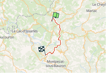
![](/images/other/stat-length.png)
![Trail Equestrian Sainte-Eulalie - Boucle Le Bouteirou - Mont Gerbier de Jonc - Etape 2 - Photo](https://media.geolcdn.com/t/1900/400/ext.pjpeg?maxdim=2&url=https%3A%2F%2Fservices.sitytrail.com%2FGeolivesWS%2FDownloadMedia.ashx%3FTrailID%3D103194%26Media%3D5041_4.jpg)
Boucle Le Bouteirou - Mont Gerbier de Jonc - Etape 2
tracegps
User
![Length](/images/other/stat-length.png)
![Max alt](https://static1.geolcdn.com/siteimages/upload/files/1508320355ic_sort_altitude_max_24dp.png)
![Uphill gradient](https://static1.geolcdn.com/siteimages/upload/files/1508320355ic_sort_den_pos_24dp.png)
![Km-Effort](/images/other/stat-length.png)
![Min alt](https://static1.geolcdn.com/siteimages/upload/files/1508320355ic_sort_altitude_min_24dp.png)
![Downhill gradient](https://static1.geolcdn.com/siteimages/upload/files/1508320355ic_sort_den_neg_24dp.png)
![Boucle](https://static1.geolcdn.com/siteimages/upload/files/16400158638029165_repeat_loop_refresh_sync_direction_icon.png)
![Equestrian](https://static1.geolcdn.com/sitytour/trail-icons/300.png)
4h00
Difficulty : Medium
![Scan this QR Code to open this trail in the SityTrail application](https://capi.geolives.com/qq0zvz2zws4bq2lad0pu/sitytour/trails/103194/qr.png?size=200)
FREE GPS app for hiking
About
Trail Equestrian of 25 km to be discovered at Auvergne-Rhône-Alpes, Ardèche, Sainte-Eulalie. This trail is proposed by tracegps.
Description
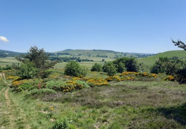
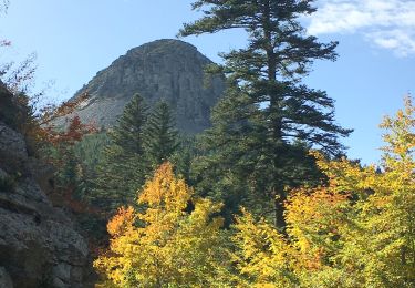
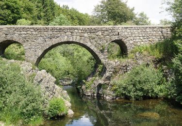
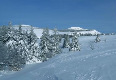
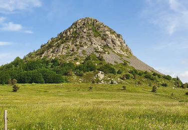
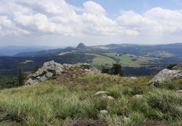
Boucle Le Bouteirou - Mont Gerbier de Jonc – Etape 2 De Villevielle à l’auberge Le Rousset du Lac en passant par le Mont Gerbier de Joncs tout en suivant la ligne de partage des eaux. Passage à la Vestide du Pal, le plus grand cratère d'Europe, et le lac Ferrant. Une randonnée suggérée par Le Bouteirou.
Positioning
Comments
Trails nearby
![Trail Walking Cros-de-Géorand - 2023-01-26_11h39m18_Le Béage-Tour des Sucs 15km.gpx.xml - Photo](https://media.geolcdn.com/t/375/260/6453586f-359e-4cec-ac7d-b8d2edfcbed0.jpg&format=jpg&maxdim=2)
![Walking Walking](https://static1.geolcdn.com/sitytour/trail-icons/101.png)
Walking
![](/images/other/stat-length.png)
![](https://static1.geolcdn.com/siteimages/upload/files/16400158638029165_repeat_loop_refresh_sync_direction_icon.png)
![Trail Walking Le Béage - suc du montfol et lauzière - Photo](https://media.geolcdn.com/t/375/260/d7f86ecc-e74b-4b11-a732-571b54443e1e.jpg&format=jpg&maxdim=2)
![Walking Walking](https://static1.geolcdn.com/sitytour/trail-icons/101.png)
Walking
![](/images/other/stat-length.png)
![](https://static1.geolcdn.com/siteimages/upload/files/16400158638029165_repeat_loop_refresh_sync_direction_icon.png)
![Trail Walking Sagnes-et-Goudoulet - Les Coux-Sagnes-Tour à Eau 14km - Photo](https://media.geolcdn.com/t/375/260/7bfff9d7-91a3-4852-a6bf-dd6f46240ce8.jpg&format=jpg&maxdim=2)
![Walking Walking](https://static1.geolcdn.com/sitytour/trail-icons/101.png)
Walking
![](/images/other/stat-length.png)
![](https://static1.geolcdn.com/siteimages/upload/files/16400158638029165_repeat_loop_refresh_sync_direction_icon.png)
![Walking Walking](https://static1.geolcdn.com/sitytour/trail-icons/101.png)
Walking
![](/images/other/stat-length.png)
![](https://static1.geolcdn.com/siteimages/upload/files/16400158638029165_repeat_loop_refresh_sync_direction_icon.png)
![Trail Walking Saint-Andéol-de-Fourchades - Boucle de la ferme de Bourdalier à Sagnes-et-Gourdoulet - Photo](https://media.geolcdn.com/t/375/260/31c1868a-b2a8-47e4-b863-8b44b5da618e.jpg&format=jpg&maxdim=2)
![Walking Walking](https://static1.geolcdn.com/sitytour/trail-icons/101.png)
Walking
![](/images/other/stat-length.png)
![](https://static1.geolcdn.com/siteimages/upload/files/16400158638029165_repeat_loop_refresh_sync_direction_icon.png)
![Trail Walking Sainte-Eulalie - 2023-01-26_11h39m37_Sucs Montfol et La Lauzière 11km.gpx.xml - Photo](https://media.geolcdn.com/t/375/260/23607b52-b0d6-4888-813e-934a0c1347d5.jpg&format=jpg&maxdim=2)
![Walking Walking](https://static1.geolcdn.com/sitytour/trail-icons/101.png)
Walking
![](/images/other/stat-length.png)
![](https://static1.geolcdn.com/siteimages/upload/files/16400158638029165_repeat_loop_refresh_sync_direction_icon.png)
![Trail Walking Saint-Martial - 2023-01-26_11h38m36_Gerbier Sentier botanique 14km.gpx.xml - Photo](https://media.geolcdn.com/t/375/260/908a31be-ec11-4c97-9939-f22f3cd5b90e.jpg&format=jpg&maxdim=2)
![Walking Walking](https://static1.geolcdn.com/sitytour/trail-icons/101.png)
Walking
![](/images/other/stat-length.png)
![](https://static1.geolcdn.com/siteimages/upload/files/16400158638029165_repeat_loop_refresh_sync_direction_icon.png)
![Trail Walking Saint-Martial - Sucs de Montfol et de La Lauziere 11km - Photo](https://media.geolcdn.com/t/375/260/fd91bba3-da8c-4cb2-aef6-1d2d0c70297e.jpg&format=jpg&maxdim=2)
![Walking Walking](https://static1.geolcdn.com/sitytour/trail-icons/101.png)
Walking
![](/images/other/stat-length.png)
![](https://static1.geolcdn.com/siteimages/upload/files/16400158638029165_repeat_loop_refresh_sync_direction_icon.png)
![Trail Walking Sagnes-et-Goudoulet - Les Coux - Sagne et Goudoulet - La Tour à Eau 14km - Photo](https://media.geolcdn.com/t/375/260/e50b9160-d833-4b37-8588-2eb7f9e44f6b.jpg&format=jpg&maxdim=2)
![Walking Walking](https://static1.geolcdn.com/sitytour/trail-icons/101.png)
Walking
![](/images/other/stat-length.png)
![](https://static1.geolcdn.com/siteimages/upload/files/16400158638029165_repeat_loop_refresh_sync_direction_icon.png)