![](/images/other/stat-length.png)
- Trails
- Cycle
- France
- Provence-Alpes-Côte d'Azur
- Hautes-Alpes
Hautes-Alpes, Provence-Alpes-Côte d'Azur, Cycle: Best trails, routes and walks
Hautes-Alpes: Discover the best trails: 62 cycle, 196 road bike, 757 mountain bike, 16 hybrid bike, 8 bicycle tourism and 88 electric bike. All these trails, routes and outdoor activities are available in our SityTrail applications for smartphones and tablets.
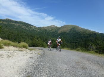
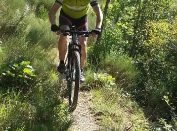
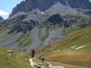
The best trails (1119)
![Trail Mountain bike Veynes - VTT29 - Rando famille - Photo](https://media.geolcdn.com/t/350/260/ext.jpg?maxdim=2&url=https%3A%2F%2Fservices.sitytrail.com%2FGeolivesWS%2FDownloadMedia.ashx%3FTrailID%3D894049%26Media%3D41fd01b2-a1b9-4de0-b05b-7c7f08af0a98.jpg)
![Mountain bike Mountain bike](https://static1.geolcdn.com/sitytour/trail-icons/202.png)
Km
Mountain bike
![](/images/other/stat-length.png)
![](https://static1.geolcdn.com/siteimages/upload/files/1508320355ic_sort_den_pos_24dp.png)
![](https://static1.geolcdn.com/siteimages/upload/files/1508320355ic_sort_den_neg_24dp.png)
![](https://static1.geolcdn.com/siteimages/upload/files/16400158638029165_repeat_loop_refresh_sync_direction_icon.png)
• 10 kms of forest roads to start mountain biking. Very nice, beautiful points of view. To do also during a first outin...
![Trail Mountain bike Veynes - VTT14 - Les crêtes de la Longeagne - Photo](https://media.geolcdn.com/t/350/260/ext.jpg?maxdim=2&url=https%3A%2F%2Fservices.sitytrail.com%2FGeolivesWS%2FDownloadMedia.ashx%3FTrailID%3D893997%26Media%3D7ccf264f-f2dd-40d2-9710-b4f1366285f7.jpg)
![Mountain bike Mountain bike](https://static1.geolcdn.com/sitytour/trail-icons/202.png)
Km
Mountain bike
![](/images/other/stat-length.png)
![](https://static1.geolcdn.com/siteimages/upload/files/1508320355ic_sort_den_pos_24dp.png)
![](https://static1.geolcdn.com/siteimages/upload/files/1508320355ic_sort_den_neg_24dp.png)
![](https://static1.geolcdn.com/siteimages/upload/files/16400158638029165_repeat_loop_refresh_sync_direction_icon.png)
• Strenuous hike: count more than 2 hours of climb from the campsite to reach the summit. Beautiful forest track. Only...
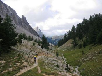
![Trail Mountain bike Veynes - VTT03 - Tous les Eygaux - Photo](https://media.geolcdn.com/t/350/260/ext.jpg?maxdim=2&url=https%3A%2F%2Fservices.sitytrail.com%2FGeolivesWS%2FDownloadMedia.ashx%3FTrailID%3D893894%26Media%3Dff964c78-0895-4177-a23a-bbf5c1f8ef2b.jpg)
![Mountain bike Mountain bike](https://static1.geolcdn.com/sitytour/trail-icons/202.png)
Km
Mountain bike
![](/images/other/stat-length.png)
![](https://static1.geolcdn.com/siteimages/upload/files/1508320355ic_sort_den_pos_24dp.png)
![](https://static1.geolcdn.com/siteimages/upload/files/1508320355ic_sort_den_neg_24dp.png)
![](https://static1.geolcdn.com/siteimages/upload/files/16400158638029165_repeat_loop_refresh_sync_direction_icon.png)
• You only have two hours and want to have fun on Single Track? This is the ideal hike! Starting from the campsite, a m...
![Trail Mountain bike Veynes - VTT02 - Aiguebelle - Photo](https://media.geolcdn.com/t/350/260/ext.jpg?maxdim=2&url=https%3A%2F%2Fservices.sitytrail.com%2FGeolivesWS%2FDownloadMedia.ashx%3FTrailID%3D893892%26Media%3Da8e741f3-b85e-4e92-89bd-a0f44b11f95d.jpg)
![Mountain bike Mountain bike](https://static1.geolcdn.com/sitytour/trail-icons/202.png)
Km
Mountain bike
![](/images/other/stat-length.png)
![](https://static1.geolcdn.com/siteimages/upload/files/1508320355ic_sort_den_pos_24dp.png)
![](https://static1.geolcdn.com/siteimages/upload/files/1508320355ic_sort_den_neg_24dp.png)
![](https://static1.geolcdn.com/siteimages/upload/files/16400158638029165_repeat_loop_refresh_sync_direction_icon.png)
• For a first approach to trail biking, which connoisseurs now call "single track" or "single", as opposed to broad for...
![Trail Mountain bike Veynes - VTT01 - Les Eygaux - Photo](https://media.geolcdn.com/t/350/260/ext.jpg?maxdim=2&url=https%3A%2F%2Fservices.sitytrail.com%2FGeolivesWS%2FDownloadMedia.ashx%3FTrailID%3D893891%26Media%3Da3cfe01b-296c-449d-80b6-97a4ee7d4f1d.jpg)
![Mountain bike Mountain bike](https://static1.geolcdn.com/sitytour/trail-icons/202.png)
Km
Mountain bike
![](/images/other/stat-length.png)
![](https://static1.geolcdn.com/siteimages/upload/files/1508320355ic_sort_den_pos_24dp.png)
![](https://static1.geolcdn.com/siteimages/upload/files/1508320355ic_sort_den_neg_24dp.png)
![](https://static1.geolcdn.com/siteimages/upload/files/16400158638029165_repeat_loop_refresh_sync_direction_icon.png)
• Easy hiking suitable for beginners. Access possible from the campsite without having to cross the road.
![Trail Road bike Veynes - C28 Les Villages du Buëch - Photo](https://media.geolcdn.com/t/350/260/1f266b5a-fdc9-4f86-9f95-2fe12b7237ca.jpg&format=jpg&maxdim=2)
![Road bike Road bike](https://static1.geolcdn.com/sitytour/trail-icons/201.png)
Km
Road bike
![](/images/other/stat-length.png)
![](https://static1.geolcdn.com/siteimages/upload/files/1508320355ic_sort_den_pos_24dp.png)
![](https://static1.geolcdn.com/siteimages/upload/files/1508320355ic_sort_den_neg_24dp.png)
![](https://static1.geolcdn.com/siteimages/upload/files/16400158638029165_repeat_loop_refresh_sync_direction_icon.png)
![Trail Road bike Veynes - C23 - Les cols de Veynes - Photo](https://media.geolcdn.com/t/350/260/9801a15f-af38-4db4-8780-c68293cbd159.jpg&format=jpg&maxdim=2)
![Road bike Road bike](https://static1.geolcdn.com/sitytour/trail-icons/201.png)
Km
Road bike
![](/images/other/stat-length.png)
![](https://static1.geolcdn.com/siteimages/upload/files/1508320355ic_sort_den_pos_24dp.png)
![](https://static1.geolcdn.com/siteimages/upload/files/1508320355ic_sort_den_neg_24dp.png)
![](https://static1.geolcdn.com/siteimages/upload/files/16400158638029165_repeat_loop_refresh_sync_direction_icon.png)
• Three ascents without exit, from the southernmost part (Céüse) to the foothills of Bure. Great climbs, beautiful arri...
![Trail Road bike Veynes - C13 - Col de Hautes Beaume - Photo](https://media.geolcdn.com/t/350/260/d8d98208-444c-47c9-b52f-780053f18efd.jpg&format=jpg&maxdim=2)
![Road bike Road bike](https://static1.geolcdn.com/sitytour/trail-icons/201.png)
Km
Road bike
![](/images/other/stat-length.png)
![](https://static1.geolcdn.com/siteimages/upload/files/1508320355ic_sort_den_pos_24dp.png)
![](https://static1.geolcdn.com/siteimages/upload/files/1508320355ic_sort_den_neg_24dp.png)
![](https://static1.geolcdn.com/siteimages/upload/files/16400158638029165_repeat_loop_refresh_sync_direction_icon.png)
• Beautiful wild circuit. Only 5 kms on a busy road (to the village of La Faurie). But then, the climb on the pass of H...
![Trail Road bike Veynes - C07 - Le Tour de Céüse - Photo](https://media.geolcdn.com/t/350/260/dfe77caf-ac2c-4dad-b455-99d86b7579fb.jpg&format=jpg&maxdim=2)
![Road bike Road bike](https://static1.geolcdn.com/sitytour/trail-icons/201.png)
Km
Road bike
![](/images/other/stat-length.png)
![](https://static1.geolcdn.com/siteimages/upload/files/1508320355ic_sort_den_pos_24dp.png)
![](https://static1.geolcdn.com/siteimages/upload/files/1508320355ic_sort_den_neg_24dp.png)
![](https://static1.geolcdn.com/siteimages/upload/files/16400158638029165_repeat_loop_refresh_sync_direction_icon.png)
• We really recommend this hike starting with the climb of Col d'Espréaux. Nice descent on the valley of the Durance, b...
![Trail Road bike Veynes - C05 - Petit et Grand Buëch - Photo](https://media.geolcdn.com/t/350/260/9d9f275d-2329-4a6f-b7aa-e2a60aab633a.jpg&format=jpg&maxdim=2)
![Road bike Road bike](https://static1.geolcdn.com/sitytour/trail-icons/201.png)
Km
Road bike
![](/images/other/stat-length.png)
![](https://static1.geolcdn.com/siteimages/upload/files/1508320355ic_sort_den_pos_24dp.png)
![](https://static1.geolcdn.com/siteimages/upload/files/1508320355ic_sort_den_neg_24dp.png)
![](https://static1.geolcdn.com/siteimages/upload/files/16400158638029165_repeat_loop_refresh_sync_direction_icon.png)
• 65 km with only 650m of elevation gain, this is rare in the Hautes Alpes! Here is a hike for those who do not like th...
![Trail Mountain bike Veynes - VTT06 - Col de Seille - Photo](https://media.geolcdn.com/t/350/260/ext.jpg?maxdim=2&url=https%3A%2F%2Fservices.sitytrail.com%2FGeolivesWS%2FDownloadMedia.ashx%3FTrailID%3D901386%26Media%3D623ed675-bf71-4ee5-8e03-18c7f8201dfe.jpg)
![Mountain bike Mountain bike](https://static1.geolcdn.com/sitytour/trail-icons/202.png)
Km
Mountain bike
![](/images/other/stat-length.png)
![](https://static1.geolcdn.com/siteimages/upload/files/1508320355ic_sort_den_pos_24dp.png)
![](https://static1.geolcdn.com/siteimages/upload/files/1508320355ic_sort_den_neg_24dp.png)
![](https://static1.geolcdn.com/siteimages/upload/files/16400158638029165_repeat_loop_refresh_sync_direction_icon.png)
• A nice circuit, with a long climb to the Col de Seille. A first single at the beginning of the hike very playful, an...
![Trail Mountain bike Manteyer - VTT32 aspremont - Photo](https://media.geolcdn.com/t/350/260/ext.jpg?maxdim=2&url=https%3A%2F%2Fservices.sitytrail.com%2FGeolivesWS%2FDownloadMedia.ashx%3FTrailID%3D894053%26Media%3Dff964c78-0895-4177-a23a-bbf5c1f8ef2b.jpg)
![Mountain bike Mountain bike](https://static1.geolcdn.com/sitytour/trail-icons/202.png)
Km
Mountain bike
![](/images/other/stat-length.png)
![](https://static1.geolcdn.com/siteimages/upload/files/1508320355ic_sort_den_pos_24dp.png)
![](https://static1.geolcdn.com/siteimages/upload/files/1508320355ic_sort_den_neg_24dp.png)
![](https://static1.geolcdn.com/siteimages/upload/files/16400158638029165_repeat_loop_refresh_sync_direction_icon.png)
• From the campsite, a series of single tracks more or less technical. Very beautiful mountain bike on a short distance...
![Trail Mountain bike Veynes - VTT09 - Vallée d'Agnielles - Photo](https://media.geolcdn.com/t/350/260/ext.jpg?maxdim=2&url=https%3A%2F%2Fservices.sitytrail.com%2FGeolivesWS%2FDownloadMedia.ashx%3FTrailID%3D887082%26Media%3Da3cfe01b-296c-449d-80b6-97a4ee7d4f1d.jpg)
![Mountain bike Mountain bike](https://static1.geolcdn.com/sitytour/trail-icons/202.png)
Km
Mountain bike
![](/images/other/stat-length.png)
![](https://static1.geolcdn.com/siteimages/upload/files/1508320355ic_sort_den_pos_24dp.png)
![](https://static1.geolcdn.com/siteimages/upload/files/1508320355ic_sort_den_neg_24dp.png)
![](https://static1.geolcdn.com/siteimages/upload/files/16400158638029165_repeat_loop_refresh_sync_direction_icon.png)
• This hike can be done in both directions. It borrows only the track (no single track), except for a few meters in the...
![Trail Mountain bike Les Orres - Les Orres 1800 - Savines le Lac - Photo](https://media.geolcdn.com/t/350/260/ext.jpg?maxdim=2&url=https%3A%2F%2Fservices.sitytrail.com%2FGeolivesWS%2FDownloadMedia.ashx%3FTrailID%3D105450%26Media%3D9182_3.jpg)
![Mountain bike Mountain bike](https://static1.geolcdn.com/sitytour/trail-icons/202.png)
Km
Mountain bike
![](/images/other/stat-length.png)
![](https://static1.geolcdn.com/siteimages/upload/files/1508320355ic_sort_den_pos_24dp.png)
![](https://static1.geolcdn.com/siteimages/upload/files/1508320355ic_sort_den_neg_24dp.png)
![](https://static1.geolcdn.com/siteimages/upload/files/16400158638029165_repeat_loop_refresh_sync_direction_icon.png)
![Trail Mountain bike Névache - Tour des Rois Mages en VTT - Névache - Photo](https://media.geolcdn.com/t/350/260/ext.jpg?maxdim=2&url=https%3A%2F%2Fservices.sitytrail.com%2FGeolivesWS%2FDownloadMedia.ashx%3FTrailID%3D105140%26Media%3D8755_6.jpg)
![Mountain bike Mountain bike](https://static1.geolcdn.com/sitytour/trail-icons/202.png)
Km
Mountain bike
![](/images/other/stat-length.png)
![](https://static1.geolcdn.com/siteimages/upload/files/1508320355ic_sort_den_pos_24dp.png)
![](https://static1.geolcdn.com/siteimages/upload/files/1508320355ic_sort_den_neg_24dp.png)
![](https://static1.geolcdn.com/siteimages/upload/files/16400158638029165_repeat_loop_refresh_sync_direction_icon.png)
![Trail Mountain bike Val-des-Prés - Montgenèvre et col de la Lauze - Photo](https://media.geolcdn.com/t/350/260/ext.jpg?maxdim=2&url=https%3A%2F%2Fservices.sitytrail.com%2FGeolivesWS%2FDownloadMedia.ashx%3FTrailID%3D101077%26Media%3D567_3.jpg)
![Mountain bike Mountain bike](https://static1.geolcdn.com/sitytour/trail-icons/202.png)
Km
Mountain bike
![](/images/other/stat-length.png)
![](https://static1.geolcdn.com/siteimages/upload/files/1508320355ic_sort_den_pos_24dp.png)
![](https://static1.geolcdn.com/siteimages/upload/files/1508320355ic_sort_den_neg_24dp.png)
![](https://static1.geolcdn.com/siteimages/upload/files/16400158638029165_repeat_loop_refresh_sync_direction_icon.png)
![Trail Mountain bike Châteauneuf-d'Oze - ceuse9 avril 2012 - Photo](https://media.geolcdn.com/t/350/260/ext.jpg?maxdim=2&url=https%3A%2F%2Fstatic1.geolcdn.com%2Fsiteimages%2Fupload%2Ffiles%2F1524743154velo.jpg)
![Mountain bike Mountain bike](https://static1.geolcdn.com/sitytour/trail-icons/202.png)
Km
Mountain bike
![](/images/other/stat-length.png)
![](https://static1.geolcdn.com/siteimages/upload/files/1508320355ic_sort_den_pos_24dp.png)
![](https://static1.geolcdn.com/siteimages/upload/files/1508320355ic_sort_den_neg_24dp.png)
![](https://static1.geolcdn.com/siteimages/upload/files/16400158638029165_repeat_loop_refresh_sync_direction_icon.png)
• magnifique
![Trail Mountain bike Château-Ville-Vieille - Tour du Queyras - Photo](https://media.geolcdn.com/t/350/260/ext.jpg?maxdim=2&url=https%3A%2F%2Fservices.sitytrail.com%2FGeolivesWS%2FDownloadMedia.ashx%3FTrailID%3D101000%26Media%3D499_1.jpg)
![Mountain bike Mountain bike](https://static1.geolcdn.com/sitytour/trail-icons/202.png)
Km
Mountain bike
![](/images/other/stat-length.png)
![](https://static1.geolcdn.com/siteimages/upload/files/1508320355ic_sort_den_pos_24dp.png)
![](https://static1.geolcdn.com/siteimages/upload/files/1508320355ic_sort_den_neg_24dp.png)
![](https://static1.geolcdn.com/siteimages/upload/files/16400158638029165_repeat_loop_refresh_sync_direction_icon.png)
![Trail Mountain bike La Roche-des-Arnauds - La Rivière - Photo](https://media.geolcdn.com/t/350/260/0a9ee634-fce3-4af5-9c6a-1f11e946fd54.jpg&format=jpg&maxdim=2)
![Mountain bike Mountain bike](https://static1.geolcdn.com/sitytour/trail-icons/202.png)
Km
Mountain bike
![](/images/other/stat-length.png)
![](https://static1.geolcdn.com/siteimages/upload/files/1508320355ic_sort_den_pos_24dp.png)
![](https://static1.geolcdn.com/siteimages/upload/files/1508320355ic_sort_den_neg_24dp.png)
![](https://static1.geolcdn.com/siteimages/upload/files/16400158638029165_repeat_loop_refresh_sync_direction_icon.png)
![Trail Mountain bike Savines-le-Lac - circuit de serre verger N°25 - Photo](https://media.geolcdn.com/t/350/260/ext.jpg?maxdim=2&url=https%3A%2F%2Fstatic1.geolcdn.com%2Fsiteimages%2Fupload%2Ffiles%2F1524743154velo.jpg)
![Mountain bike Mountain bike](https://static1.geolcdn.com/sitytour/trail-icons/202.png)
Km
Mountain bike
![](/images/other/stat-length.png)
![](https://static1.geolcdn.com/siteimages/upload/files/1508320355ic_sort_den_pos_24dp.png)
![](https://static1.geolcdn.com/siteimages/upload/files/1508320355ic_sort_den_neg_24dp.png)
![](https://static1.geolcdn.com/siteimages/upload/files/16400158638029165_repeat_loop_refresh_sync_direction_icon.png)
• montée sans difficulté technique, descente sportive quand même,surtout par sol humide.
20 trails displayed on 1119
FREE GPS app for hiking
Activities
Nearby regions
- Abriès-Ristolas
- Aiguilles
- Ancelle
- Arvieux
- Aspremont
- Aspres-lès-Corps
- Aspres-sur-Buëch
- Aubessagne
- Avançon
- Baratier
- Barcillonnette
- Barret-sur-Méouge
- Bréziers
- Briançon
- Buissard
- Ceillac
- Cervières
- Chabestan
- Chabottes
- Champcella
- Champoléon
- Chanousse
- Château-Ville-Vieille
- Châteauneuf-d'Oze
- Châteauroux-les-Alpes
- Châteauvieux
- Chorges
- Crévoux
- Crots
- Embrun
- Éourres
- Esparron
- Espinasses
- Étoile-Saint-Cyrice
- Eygliers
- Forest-Saint-Julien
- Fouillouse
- Freissinières
- Furmeyer
- Gap
- Garde-Colombe
- Guillestre
- Jarjayes
- L'Argentière-la-Bessée
- L'Épine
- La Bâtie-Montsaléon
- La Bâtie-Neuve
- La Bâtie-Vieille
- La Beaume
- La Chapelle-en-Valgaudémar
- La Fare-en-Champsaur
- La Faurie
- La Freissinouse
- La Grave
- La Haute-Beaume
- La Motte-en-Champsaur
- La Piarre
- La Roche-de-Rame
- La Roche-des-Arnauds
- La Rochette
- La Salle-les-Alpes
- La Saulce
- Laragne-Montéglin
- Lardier-et-Valença
- Laye
- Lazer
- Le Bersac
- Le Dévoluy
- Le Glaizil
- Le Monêtier-les-Bains
- Le Noyer
- Le Poët
- Le Saix
- Le Sauze-du-Lac
- Les Orres
- Les Vigneaux
- Lettret
- Manteyer
- Méreuil
- Molines-en-Queyras
- Monêtier-Allemont
- Mont-Dauphin
- Montbrand
- Montclus
- Montgardin
- Montgenèvre
- Montjay
- Montmaur
- Montrond
- Moydans
- Neffes
- Névache
- Nossage-et-Bénévent
- Orcières
- Orpierre
- Oze
- Pelleautier
- Poligny
- Prunières
- Puy-Saint-André
- Puy-Saint-Eusèbe
- Puy-Saint-Pierre
- Puy-Saint-Vincent
- Puy-Sanières
- Rabou
- Rambaud
- Réallon
- Remollon
- Réotier
- Ribeyret
- Risoul
- Rochebrune
- Rosans
- Rousset
- Saint-André-d'Embrun
- Saint-André-de-Rosans
- Saint-Apollinaire
- Saint-Auban-d'Oze
- Saint-Bonnet-en-Champsaur
- Saint-Chaffrey
- Saint-Clément-sur-Durance
- Saint-Crépin
- Saint-Étienne-le-Laus
- Saint-Firmin
- Saint-Jacques-en-Valgodemard
- Saint-Jean-Saint-Nicolas
- Saint-Julien-en-Beauchêne
- Saint-Julien-en-Champsaur
- Saint-Laurent-du-Cros
- Saint-Léger-les-Mélèzes
- Saint-Martin-de-Queyrières
- Saint-Maurice-en-Valgodemard
- Saint-Michel-de-Chaillol
- Saint-Pierre-Avez
- Saint-Pierre-d'Argençon
- Saint-Sauveur
- Saint-Véran
- Sainte-Colombe
- Saléon
- Salérans
- Savines-le-Lac
- Savournon
- Serres
- Sigottier
- Sigoyer
- Sorbiers
- Tallard
- Théus
- Trescléoux
- Upaix
- Val-Buëch-Méouge
- Val-des-Prés
- Valdoule
- Vallouise-Pelvoux
- Valserres
- Vars
- Ventavon
- Veynes
- Villar-Loubière
- Villar-Saint-Pancrace
- Villar-d'Arêne
- Vitrolles