![](/images/other/stat-length.png)
![Tocht Stappen Kenmare Municipal District - Gap of Dunloe - Photo](https://media.geolcdn.com/t/1900/400/a45f8ed4-3ebb-45e2-a23a-debd623bea8b.jpg&format=pjpeg&maxdim=2)
Gap of Dunloe
Lobin
Gebruiker
![Lengte](/images/other/stat-length.png)
Lengte
11,1 km
![Max. hoogte](https://static1.geolcdn.com/siteimages/upload/files/1508320355ic_sort_altitude_max_24dp.png)
Max. hoogte
243 m
![Positief hoogteverschil](https://static1.geolcdn.com/siteimages/upload/files/1508320355ic_sort_den_pos_24dp.png)
Positief hoogteverschil
222 m
![Km-Effort](/images/other/stat-length.png)
Km-Effort
14,2 km
![Min. hoogte](https://static1.geolcdn.com/siteimages/upload/files/1508320355ic_sort_altitude_min_24dp.png)
Min. hoogte
23 m
![Negatief hoogteverschil](https://static1.geolcdn.com/siteimages/upload/files/1508320355ic_sort_den_neg_24dp.png)
Negatief hoogteverschil
256 m
![Boucle](https://static1.geolcdn.com/siteimages/upload/files/16400158638029165_repeat_loop_refresh_sync_direction_icon.png)
Boucle
Neen
Datum van aanmaak :
2024-03-31 09:50:56.0
Laatste wijziging :
2024-03-31 15:25:46.812
![Stappen](https://static1.geolcdn.com/sitytour/trail-icons/101.png)
2h26
Moeilijkheid : Medium
![Scan deze QR-code om de tocht te openen in de SityTrail-applicatie](https://capi.geolives.com/qq0zvz2zws4bq2lad0pu/sitytour/trails/3999877/qr.png?size=200)
Gratisgps-wandelapplicatie
Over ons
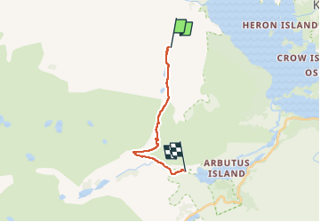
Tocht Stappen van 11,1 km beschikbaar op Onbekend, County Kerry, Kenmare Municipal District. Deze tocht wordt voorgesteld door Lobin.
Beschrijving
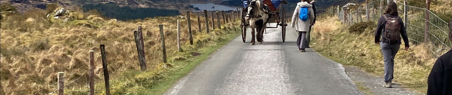
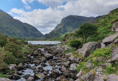
Il faut réserver la dépose en minibus au départ de la rando avec un Retour via les lacs.
Le chemin est une route mais ça vaut le coup. Le retour par les lacs est superbe
Plaatsbepaling
Land:
Ireland
Regio :
Onbekend
Departement/Provincie :
County Kerry
Gemeente :
Kenmare Municipal District
Locatie:
Dunloe
Vertrek:(Dec)
Vertrek:(UTM)
456531 ; 5765573 (29U) N.
Opmerkingen
Wandeltochten in de omgeving
![Tocht Stappen Kenmare Municipal District - Parc National Killarney - Photo](https://media.geolcdn.com/t/375/260/12bfd884-912f-41c3-80f5-cf037d906335.jpg&format=jpg&maxdim=2)
![Stappen Stappen](https://static1.geolcdn.com/sitytour/trail-icons/101.png)
Parc National Killarney
Stappen
Zeer moeilijk
Kenmare Municipal District,
Onbekend,
County Kerry,
Ireland
![](/images/other/stat-length.png)
28 km | 32 km-effort
7h 10min
![](https://static1.geolcdn.com/siteimages/upload/files/16400158638029165_repeat_loop_refresh_sync_direction_icon.png)
Neen
![Tocht Stappen Kenmare Municipal District - Purlp montain - Photo](https://media.geolcdn.com/t/375/260/ext.jpg?maxdim=2&url=https%3A%2F%2Fstatic1.geolcdn.com%2Fsiteimages%2Fupload%2Ffiles%2F1553511878bg_sport_marche.png)
![Stappen Stappen](https://static1.geolcdn.com/sitytour/trail-icons/101.png)
Purlp montain
Stappen
Moeilijk
Kenmare Municipal District,
Onbekend,
County Kerry,
Ireland
![](/images/other/stat-length.png)
14,5 km | 21 km-effort
Onbekend
![](https://static1.geolcdn.com/siteimages/upload/files/16400158638029165_repeat_loop_refresh_sync_direction_icon.png)
Ja
![Tocht Mountainbike Kenmare Municipal District - Gap of Dunloe 2 - Photo](https://media.geolcdn.com/t/375/260/ext.jpg?maxdim=2&url=https%3A%2F%2Fstatic1.geolcdn.com%2Fsiteimages%2Fupload%2Ffiles%2F1524743154velo.jpg)
![Mountainbike Mountainbike](https://static1.geolcdn.com/sitytour/trail-icons/202.png)
Gap of Dunloe 2
Mountainbike
Zeer moeilijk
Kenmare Municipal District,
Onbekend,
County Kerry,
Ireland
![](/images/other/stat-length.png)
46 km | 55 km-effort
3h 47min
![](https://static1.geolcdn.com/siteimages/upload/files/16400158638029165_repeat_loop_refresh_sync_direction_icon.png)
Ja