![](/images/other/stat-length.png)
![Tocht Sneeuwschoenen Saint-Sauveur - Les saletés Chantal - Photo](https://media.geolcdn.com/t/1900/400/ext.pjpeg?maxdim=2&url=https%3A%2F%2Fstatic1.geolcdn.com%2Fsiteimages%2Fupload%2Ffiles%2F1524743153raquette.jpg)
Les saletés Chantal
damlou
Gebruiker
![Lengte](/images/other/stat-length.png)
Lengte
4,8 km
![Max. hoogte](https://static1.geolcdn.com/siteimages/upload/files/1508320355ic_sort_altitude_max_24dp.png)
Max. hoogte
1371 m
![Positief hoogteverschil](https://static1.geolcdn.com/siteimages/upload/files/1508320355ic_sort_den_pos_24dp.png)
Positief hoogteverschil
244 m
![Km-Effort](/images/other/stat-length.png)
Km-Effort
8,1 km
![Min. hoogte](https://static1.geolcdn.com/siteimages/upload/files/1508320355ic_sort_altitude_min_24dp.png)
Min. hoogte
1121 m
![Negatief hoogteverschil](https://static1.geolcdn.com/siteimages/upload/files/1508320355ic_sort_den_neg_24dp.png)
Negatief hoogteverschil
243 m
![Boucle](https://static1.geolcdn.com/siteimages/upload/files/16400158638029165_repeat_loop_refresh_sync_direction_icon.png)
Boucle
Ja
Datum van aanmaak :
2023-01-27 08:19:27.859
Laatste wijziging :
2023-01-27 11:08:31.157
![Sneeuwschoenen](https://static1.geolcdn.com/sitytour/trail-icons/504.png)
1h38
Moeilijkheid : Medium
![Scan deze QR-code om de tocht te openen in de SityTrail-applicatie](https://capi.geolives.com/qq0zvz2zws4bq2lad0pu/sitytour/trails/3531677/qr.png?size=200)
Gratisgps-wandelapplicatie
Over ons
Tocht Sneeuwschoenen van 4,8 km beschikbaar op Provence-Alpes-Côte d'Azur, Hautes-Alpes, Saint-Sauveur. Deze tocht wordt voorgesteld door damlou.
Beschrijving
Départ les saletés
Montee en zig Zag moyenne
Direction la Mazellière possibilité de continuer tout droit vers la Mazellière
Descente vers le Meale
Neige très bonne Nord Est
super descente
Plaatsbepaling
Land:
France
Regio :
Provence-Alpes-Côte d'Azur
Departement/Provincie :
Hautes-Alpes
Gemeente :
Saint-Sauveur
Locatie:
Unknown
Vertrek:(Dec)
Vertrek:(UTM)
303061 ; 4932571 (32T) N.
Opmerkingen
Wandeltochten in de omgeving
![Tocht Stappen Les Orres - lac de Sainte Marguerite Les Orres - Photo](https://media.geolcdn.com/t/375/260/ext.jpg?maxdim=2&url=https%3A%2F%2Fservices.sitytrail.com%2FGeolivesWS%2FDownloadMedia.ashx%3FTrailID%3D1018436%26Media%3Dfix__20180808142719.jpg)
![Stappen Stappen](https://static1.geolcdn.com/sitytour/trail-icons/101.png)
lac de Sainte Marguerite Les Orres
Stappen
Medium
(2)
Les Orres,
Provence-Alpes-Côte d'Azur,
Hautes-Alpes,
France
![](/images/other/stat-length.png)
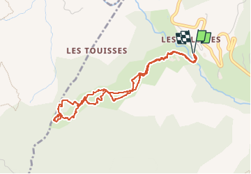
11,1 km | 19 km-effort
4h 25min
![](https://static1.geolcdn.com/siteimages/upload/files/16400158638029165_repeat_loop_refresh_sync_direction_icon.png)
Ja
![Tocht Stappen Les Orres - 2012-08-10_Sentier du garde - Photo](https://media.geolcdn.com/t/375/260/ext.jpg?maxdim=2&url=https%3A%2F%2Fservices.sitytrail.com%2FGeolivesWS%2FDownloadMedia.ashx%3FTrailID%3D145344%26Media%3D3eb37f19-c6a6-4c29-8161-da219dedd017.jpeg)
![Stappen Stappen](https://static1.geolcdn.com/sitytour/trail-icons/101.png)
2012-08-10_Sentier du garde
Stappen
Medium
(1)
Les Orres,
Provence-Alpes-Côte d'Azur,
Hautes-Alpes,
France
![](/images/other/stat-length.png)
11,3 km | 17,6 km-effort
4h 6min
![](https://static1.geolcdn.com/siteimages/upload/files/16400158638029165_repeat_loop_refresh_sync_direction_icon.png)
Ja
![Tocht Stappen Saint-Sauveur - 2012-08-07 Méale - Photo](https://media.geolcdn.com/t/375/260/ext.jpg?maxdim=2&url=https%3A%2F%2Fservices.sitytrail.com%2FGeolivesWS%2FDownloadMedia.ashx%3FTrailID%3D145125%26Media%3D8f8ba6a5-bed5-4779-b0c7-5d5fa06c0aa0.jpeg)
![Stappen Stappen](https://static1.geolcdn.com/sitytour/trail-icons/101.png)
2012-08-07 Méale
Stappen
Moeilijk
(1)
Saint-Sauveur,
Provence-Alpes-Côte d'Azur,
Hautes-Alpes,
France
![](/images/other/stat-length.png)
8,3 km | 14,9 km-effort
3h 34min
![](https://static1.geolcdn.com/siteimages/upload/files/16400158638029165_repeat_loop_refresh_sync_direction_icon.png)
Ja
![Tocht Mountainbike Les Orres - Les Orres 1800 - Savines le Lac - Photo](https://media.geolcdn.com/t/375/260/ext.jpg?maxdim=2&url=https%3A%2F%2Fservices.sitytrail.com%2FGeolivesWS%2FDownloadMedia.ashx%3FTrailID%3D105450%26Media%3D9182_3.jpg)
![Mountainbike Mountainbike](https://static1.geolcdn.com/sitytour/trail-icons/202.png)
Les Orres 1800 - Savines le Lac
Mountainbike
Moeilijk
(1)
Les Orres,
Provence-Alpes-Côte d'Azur,
Hautes-Alpes,
France
![](/images/other/stat-length.png)
28 km | 42 km-effort
3h 0min
![](https://static1.geolcdn.com/siteimages/upload/files/16400158638029165_repeat_loop_refresh_sync_direction_icon.png)
Neen
![Tocht Stappen Les Orres - l'Aupillon - Photo](https://media.geolcdn.com/t/375/260/38306995-9c71-4e70-80a5-d8bb94d45592.jpg&format=jpg&maxdim=2)
![Stappen Stappen](https://static1.geolcdn.com/sitytour/trail-icons/101.png)
l'Aupillon
Stappen
Moeilijk
Les Orres,
Provence-Alpes-Côte d'Azur,
Hautes-Alpes,
France
![](/images/other/stat-length.png)
16,8 km | 33 km-effort
7h 43min
![](https://static1.geolcdn.com/siteimages/upload/files/16400158638029165_repeat_loop_refresh_sync_direction_icon.png)
Ja
![Tocht Stappen Les Orres - le Pouzenc - Photo](https://media.geolcdn.com/t/375/260/efe95a97-87aa-4d7d-b7d6-f810bef16b2e.jpg&format=jpg&maxdim=2)
![Stappen Stappen](https://static1.geolcdn.com/sitytour/trail-icons/101.png)
le Pouzenc
Stappen
Moeilijk
Les Orres,
Provence-Alpes-Côte d'Azur,
Hautes-Alpes,
France
![](/images/other/stat-length.png)
14,6 km | 31 km-effort
7h 41min
![](https://static1.geolcdn.com/siteimages/upload/files/16400158638029165_repeat_loop_refresh_sync_direction_icon.png)
Ja
![Tocht Stappen Les Orres - les orres 1800 . lac sainte marguerite / montée par le sentier et retour par la piste - Photo](https://media.geolcdn.com/t/375/260/827a9108-7754-443f-a277-3e00c67d44c5.jpg&format=jpg&maxdim=2)
![Stappen Stappen](https://static1.geolcdn.com/sitytour/trail-icons/101.png)
les orres 1800 . lac sainte marguerite / montée par le sentier et retour par ...
Stappen
Gemakkelijk
Les Orres,
Provence-Alpes-Côte d'Azur,
Hautes-Alpes,
France
![](/images/other/stat-length.png)
10,2 km | 18,2 km-effort
3h 59min
![](https://static1.geolcdn.com/siteimages/upload/files/16400158638029165_repeat_loop_refresh_sync_direction_icon.png)
Ja
![Tocht Ski randonnée Les Orres - Col de l'Âne/Eissalette - Photo](https://media.geolcdn.com/t/375/260/ext.jpg?maxdim=2&url=https%3A%2F%2Fservices.sitytrail.com%2FGeolivesWS%2FDownloadMedia.ashx%3FTrailID%3D902843%26Media%3Dd71eb2cd-1ecf-424f-b414-6dbabbfbf9c5.jpg)
![Ski randonnée Ski randonnée](https://static1.geolcdn.com/sitytour/trail-icons/503.png)
Col de l'Âne/Eissalette
Ski randonnée
Medium
Les Orres,
Provence-Alpes-Côte d'Azur,
Hautes-Alpes,
France
![](/images/other/stat-length.png)
5,3 km | 13,7 km-effort
2h 0min
![](https://static1.geolcdn.com/siteimages/upload/files/16400158638029165_repeat_loop_refresh_sync_direction_icon.png)
Neen
![Tocht Sneeuwschoenen Les Orres - Lac de Sainte Marguerite. Les ORRES - Photo](https://media.geolcdn.com/t/375/260/ext.jpg?maxdim=2&url=https%3A%2F%2Fstatic1.geolcdn.com%2Fsiteimages%2Fupload%2Ffiles%2F1524743153raquette.jpg)
![Sneeuwschoenen Sneeuwschoenen](https://static1.geolcdn.com/sitytour/trail-icons/504.png)
Lac de Sainte Marguerite. Les ORRES
Sneeuwschoenen
Medium
(2)
Les Orres,
Provence-Alpes-Côte d'Azur,
Hautes-Alpes,
France
![](/images/other/stat-length.png)
6,8 km | 13,4 km-effort
3h 26min
![](https://static1.geolcdn.com/siteimages/upload/files/16400158638029165_repeat_loop_refresh_sync_direction_icon.png)
Neen
Super balade Montée moyenne Bonne orientation Nord Est Donc neige de bonne qualité Départ aux Salettes Bonne descente poudreuse