![](/images/other/stat-length.png)
![Tocht Te voet Manresa - M8 - Itinerari El Cardener i el Puigberenguer - Photo](https://media.geolcdn.com/t/1900/400/b4802937-6b86-45e7-83a2-950c5ab95055.jpeg&format=pjpeg&maxdim=2)
M8 - Itinerari El Cardener i el Puigberenguer
SityTrail - itinéraires balisés pédestres
Tous les sentiers balisés d’Europe GUIDE+
![Lengte](/images/other/stat-length.png)
![Max. hoogte](https://static1.geolcdn.com/siteimages/upload/files/1508320355ic_sort_altitude_max_24dp.png)
![Positief hoogteverschil](https://static1.geolcdn.com/siteimages/upload/files/1508320355ic_sort_den_pos_24dp.png)
![Km-Effort](/images/other/stat-length.png)
![Min. hoogte](https://static1.geolcdn.com/siteimages/upload/files/1508320355ic_sort_altitude_min_24dp.png)
![Negatief hoogteverschil](https://static1.geolcdn.com/siteimages/upload/files/1508320355ic_sort_den_neg_24dp.png)
![Boucle](https://static1.geolcdn.com/siteimages/upload/files/16400158638029165_repeat_loop_refresh_sync_direction_icon.png)
![Te voet](https://static1.geolcdn.com/sitytour/trail-icons/100.png)
2h24
Moeilijkheid : Gemakkelijk
![Scan deze QR-code om de tocht te openen in de SityTrail-applicatie](https://capi.geolives.com/qq0zvz2zws4bq2lad0pu/sitytour/trails/3109611/qr.png?size=200)
Gratisgps-wandelapplicatie
Over ons
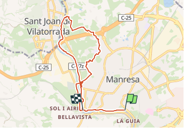
Tocht Te voet van 8,9 km beschikbaar op Catalonië, Barcelona, Manresa. Deze tocht wordt voorgesteld door SityTrail - itinéraires balisés pédestres.
Beschrijving
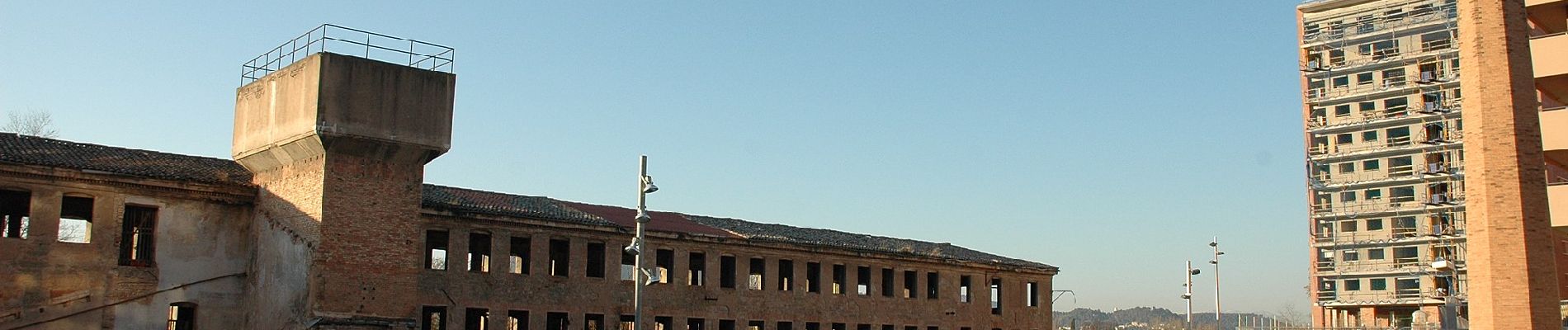
Trail created by Ajuntament de Manresa.
Ruta que pertany a l'Anella Verda de Manresa
Website: http://www.anellaverdamanresa.cat/web/article/7576-el-cardener-i-el-puigberenguer-(m8)
Plaatsbepaling
Opmerkingen
Wandeltochten in de omgeving
![Tocht Te voet Sant Joan de Vilatorrada - Rutes d'aigua i secà 6: Retalls d'història a l'espai urbà - Photo](https://media.geolcdn.com/t/375/260/532bdb52-38c7-431e-a873-3425723ec679.jpeg&format=jpg&maxdim=2)
![Te voet Te voet](https://static1.geolcdn.com/sitytour/trail-icons/100.png)
Te voet
![](/images/other/stat-length.png)
![](https://static1.geolcdn.com/siteimages/upload/files/16400158638029165_repeat_loop_refresh_sync_direction_icon.png)
![Tocht Te voet Sant Joan de Vilatorrada - Rutes d'aigua i secà 5: Per terres de regadiu i secà - Photo](https://media.geolcdn.com/t/375/260/d25fbfc6-fb35-4c29-ab09-cb754a8a46ee.jpeg&format=jpg&maxdim=2)
![Te voet Te voet](https://static1.geolcdn.com/sitytour/trail-icons/100.png)
Te voet
![](/images/other/stat-length.png)
![](https://static1.geolcdn.com/siteimages/upload/files/16400158638029165_repeat_loop_refresh_sync_direction_icon.png)
![Tocht Te voet Sant Joan de Vilatorrada - Rutes d'aigua i secà 4: Els testimònis històrics del romànic a la Guerra Civil - Photo](https://media.geolcdn.com/t/375/260/fe75d122-9d0f-4a31-abe0-e3f2b609b82e.jpeg&format=jpg&maxdim=2)
![Te voet Te voet](https://static1.geolcdn.com/sitytour/trail-icons/100.png)
Te voet
![](/images/other/stat-length.png)
![](https://static1.geolcdn.com/siteimages/upload/files/16400158638029165_repeat_loop_refresh_sync_direction_icon.png)
![Tocht Te voet Sant Joan de Vilatorrada - Rutes d'aigua i secà 3: Els antics molins del Cardener - Photo](https://media.geolcdn.com/t/375/260/4b7a23d9-4daa-4ff8-aa2a-4c16c26266b4.jpeg&format=jpg&maxdim=2)
![Te voet Te voet](https://static1.geolcdn.com/sitytour/trail-icons/100.png)
Te voet
![](/images/other/stat-length.png)
![](https://static1.geolcdn.com/siteimages/upload/files/16400158638029165_repeat_loop_refresh_sync_direction_icon.png)
![Tocht Te voet Sant Joan de Vilatorrada - Rutes d'aigua i secà 2: Obaga de Collbaix i Riera de Fonollosa - Photo](https://media.geolcdn.com/t/375/260/3219f8af-2278-413d-80d7-e95e626e51a7.jpeg&format=jpg&maxdim=2)
![Te voet Te voet](https://static1.geolcdn.com/sitytour/trail-icons/100.png)
Te voet
![](/images/other/stat-length.png)
![](https://static1.geolcdn.com/siteimages/upload/files/16400158638029165_repeat_loop_refresh_sync_direction_icon.png)
![Tocht Te voet Sant Joan de Vilatorrada - Rutes d'aigua i secà 1: Testimonis de la vinya - Photo](https://media.geolcdn.com/t/375/260/f6f65e19-62f8-4e3b-b75a-bbe6282c7796.jpeg&format=jpg&maxdim=2)
![Te voet Te voet](https://static1.geolcdn.com/sitytour/trail-icons/100.png)
Te voet
![](/images/other/stat-length.png)
![](https://static1.geolcdn.com/siteimages/upload/files/16400158638029165_repeat_loop_refresh_sync_direction_icon.png)
![Tocht Te voet Manresa - M1 - Itinerari El Collbaix - Photo](https://media.geolcdn.com/t/375/260/1039f82f-c31b-4da9-8b5f-0c780911a99c.jpeg&format=jpg&maxdim=2)
![Te voet Te voet](https://static1.geolcdn.com/sitytour/trail-icons/100.png)
Te voet
![](/images/other/stat-length.png)
![](https://static1.geolcdn.com/siteimages/upload/files/16400158638029165_repeat_loop_refresh_sync_direction_icon.png)
![Tocht Te voet Manresa - M5 - Itinerari Els cingles del Llobregat - Photo](https://media.geolcdn.com/t/375/260/3d855f2d-d3e3-4119-a547-6e2a0c6b7945.jpeg&format=jpg&maxdim=2)
![Te voet Te voet](https://static1.geolcdn.com/sitytour/trail-icons/100.png)
Te voet
![](/images/other/stat-length.png)
![](https://static1.geolcdn.com/siteimages/upload/files/16400158638029165_repeat_loop_refresh_sync_direction_icon.png)
![Tocht Te voet Manresa - M3 - Itinerari Els pous de glaç i la riera de Guardiola - Photo](https://media.geolcdn.com/t/375/260/4f1927cb-9aa6-43c9-befe-496dcb61df62.jpeg&format=jpg&maxdim=2)
![Te voet Te voet](https://static1.geolcdn.com/sitytour/trail-icons/100.png)
Te voet
![](/images/other/stat-length.png)
![](https://static1.geolcdn.com/siteimages/upload/files/16400158638029165_repeat_loop_refresh_sync_direction_icon.png)