![](/images/other/stat-length.png)
![Tocht Te voet Waldrach - Waldrach 2 - Photo](https://media.geolcdn.com/t/1900/400/5223fab9-3bc2-41d1-a8df-c5d9f817918c.jpeg&format=pjpeg&maxdim=2)
Waldrach 2
SityTrail - itinéraires balisés pédestres
Tous les sentiers balisés d’Europe GUIDE+
![Lengte](/images/other/stat-length.png)
Lengte
7,2 km
![Max. hoogte](https://static1.geolcdn.com/siteimages/upload/files/1508320355ic_sort_altitude_max_24dp.png)
Max. hoogte
415 m
![Positief hoogteverschil](https://static1.geolcdn.com/siteimages/upload/files/1508320355ic_sort_den_pos_24dp.png)
Positief hoogteverschil
234 m
![Km-Effort](/images/other/stat-length.png)
Km-Effort
10,3 km
![Min. hoogte](https://static1.geolcdn.com/siteimages/upload/files/1508320355ic_sort_altitude_min_24dp.png)
Min. hoogte
180 m
![Negatief hoogteverschil](https://static1.geolcdn.com/siteimages/upload/files/1508320355ic_sort_den_neg_24dp.png)
Negatief hoogteverschil
235 m
![Boucle](https://static1.geolcdn.com/siteimages/upload/files/16400158638029165_repeat_loop_refresh_sync_direction_icon.png)
Boucle
Ja
Markering
Datum van aanmaak :
2022-02-11 15:27:17.814
Laatste wijziging :
2022-02-11 15:27:17.814
![Te voet](https://static1.geolcdn.com/sitytour/trail-icons/100.png)
2h21
Moeilijkheid : Gemakkelijk
![Scan deze QR-code om de tocht te openen in de SityTrail-applicatie](https://capi.geolives.com/qq0zvz2zws4bq2lad0pu/sitytour/trails/3094515/qr.png?size=200)
Gratisgps-wandelapplicatie
Over ons
Tocht Te voet van 7,2 km beschikbaar op Rijnland-Palts, Landkreis Trier-Saarburg, Waldrach. Deze tocht wordt voorgesteld door SityTrail - itinéraires balisés pédestres.
Beschrijving
noch nicht vollständig erkundet. KK-O 16.10.2013
Plaatsbepaling
Land:
Germany
Regio :
Rijnland-Palts
Departement/Provincie :
Landkreis Trier-Saarburg
Gemeente :
Waldrach
Locatie:
Unknown
Vertrek:(Dec)
Vertrek:(UTM)
337514 ; 5513166 (32U) N.
Opmerkingen
Wandeltochten in de omgeving
![Tocht Te voet Gutweiler - Romika-Weg - Photo](https://media.geolcdn.com/t/375/260/644cbb1c-05bc-4e7a-906a-f58ae57c3aa1.jpeg&format=jpg&maxdim=2)
![Te voet Te voet](https://static1.geolcdn.com/sitytour/trail-icons/100.png)
Romika-Weg
Te voet
Gemakkelijk
Gutweiler,
Rijnland-Palts,
Landkreis Trier-Saarburg,
Germany
![](/images/other/stat-length.png)
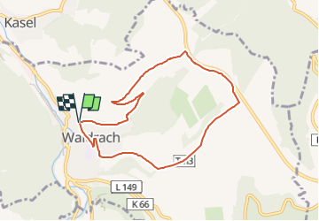
11,7 km | 16,4 km-effort
3h 43min
![](https://static1.geolcdn.com/siteimages/upload/files/16400158638029165_repeat_loop_refresh_sync_direction_icon.png)
Ja
![Tocht Te voet Kasel - DE-Ks1 - Photo](https://media.geolcdn.com/t/375/260/65bab8ad-8063-400d-b8bb-d69fbb53b547.jpeg&format=jpg&maxdim=2)
![Te voet Te voet](https://static1.geolcdn.com/sitytour/trail-icons/100.png)
DE-Ks1
Te voet
Gemakkelijk
Kasel,
Rijnland-Palts,
Landkreis Trier-Saarburg,
Germany
![](/images/other/stat-length.png)
3,5 km | 5,4 km-effort
1h 13min
![](https://static1.geolcdn.com/siteimages/upload/files/16400158638029165_repeat_loop_refresh_sync_direction_icon.png)
Neen
![Tocht Te voet Morscheid - DE-R - Photo](https://media.geolcdn.com/t/375/260/0b0cdefd-fbad-4d79-acef-5a137d3e9a95.jpeg&format=jpg&maxdim=2)
![Te voet Te voet](https://static1.geolcdn.com/sitytour/trail-icons/100.png)
DE-R
Te voet
Gemakkelijk
Morscheid,
Rijnland-Palts,
Landkreis Trier-Saarburg,
Germany
![](/images/other/stat-length.png)
13,7 km | 17,8 km-effort
4h 2min
![](https://static1.geolcdn.com/siteimages/upload/files/16400158638029165_repeat_loop_refresh_sync_direction_icon.png)
Neen
![Tocht Te voet Sommerau - Morscheider Grenzpfad - Photo](https://media.geolcdn.com/t/375/260/9327d8cb-60ee-4a45-a57a-e57e842f85f1.jpeg&format=jpg&maxdim=2)
![Te voet Te voet](https://static1.geolcdn.com/sitytour/trail-icons/100.png)
Morscheider Grenzpfad
Te voet
Medium
Sommerau,
Rijnland-Palts,
Landkreis Trier-Saarburg,
Germany
![](/images/other/stat-length.png)
16,4 km | 23 km-effort
5h 19min
![](https://static1.geolcdn.com/siteimages/upload/files/16400158638029165_repeat_loop_refresh_sync_direction_icon.png)
Ja
![Tocht Te voet Mertesdorf - Mertesdorf 1 - Photo](https://media.geolcdn.com/t/375/260/ecbb68e2-0c38-48d4-afe7-d9118f2e4b0e.jpeg&format=jpg&maxdim=2)
![Te voet Te voet](https://static1.geolcdn.com/sitytour/trail-icons/100.png)
Mertesdorf 1
Te voet
Gemakkelijk
Mertesdorf,
Rijnland-Palts,
Landkreis Trier-Saarburg,
Germany
![](/images/other/stat-length.png)
6,1 km | 8,4 km-effort
1h 53min
![](https://static1.geolcdn.com/siteimages/upload/files/16400158638029165_repeat_loop_refresh_sync_direction_icon.png)
Ja
![Tocht Te voet Onbekend - Korlingen 1 - Photo](https://media.geolcdn.com/t/375/260/8f5b3fc9-ca42-431f-babc-0124f8354220.jpeg&format=jpg&maxdim=2)
![Te voet Te voet](https://static1.geolcdn.com/sitytour/trail-icons/100.png)
Korlingen 1
Te voet
Gemakkelijk
Onbekend,
Rijnland-Palts,
Trier,
Germany
![](/images/other/stat-length.png)
7,8 km | 10,7 km-effort
2h 25min
![](https://static1.geolcdn.com/siteimages/upload/files/16400158638029165_repeat_loop_refresh_sync_direction_icon.png)
Ja
![Tocht Te voet Waldrach - RT1 - Photo](https://media.geolcdn.com/t/375/260/8f5b3fc9-ca42-431f-babc-0124f8354220.jpeg&format=jpg&maxdim=2)
![Te voet Te voet](https://static1.geolcdn.com/sitytour/trail-icons/100.png)
RT1
Te voet
Gemakkelijk
Waldrach,
Rijnland-Palts,
Landkreis Trier-Saarburg,
Germany
![](/images/other/stat-length.png)
3,6 km | 4,9 km-effort
1h 6min
![](https://static1.geolcdn.com/siteimages/upload/files/16400158638029165_repeat_loop_refresh_sync_direction_icon.png)
Neen
![Tocht Te voet Fell - DE-R13 - Photo](https://media.geolcdn.com/t/375/260/f4565e92-61c1-4858-ab6f-f96d2dbccbfb.jpeg&format=jpg&maxdim=2)
![Te voet Te voet](https://static1.geolcdn.com/sitytour/trail-icons/100.png)
DE-R13
Te voet
Gemakkelijk
Fell,
Rijnland-Palts,
Landkreis Trier-Saarburg,
Germany
![](/images/other/stat-length.png)
9,4 km | 13 km-effort
2h 57min
![](https://static1.geolcdn.com/siteimages/upload/files/16400158638029165_repeat_loop_refresh_sync_direction_icon.png)
Ja
![Tocht Te voet Riveris - Riveristalsperre - Photo](https://media.geolcdn.com/t/375/260/9327d8cb-60ee-4a45-a57a-e57e842f85f1.jpeg&format=jpg&maxdim=2)
![Te voet Te voet](https://static1.geolcdn.com/sitytour/trail-icons/100.png)
Riveristalsperre
Te voet
Gemakkelijk
Riveris,
Rijnland-Palts,
Landkreis Trier-Saarburg,
Germany
![](/images/other/stat-length.png)
7,8 km | 10,4 km-effort
2h 22min
![](https://static1.geolcdn.com/siteimages/upload/files/16400158638029165_repeat_loop_refresh_sync_direction_icon.png)
Ja