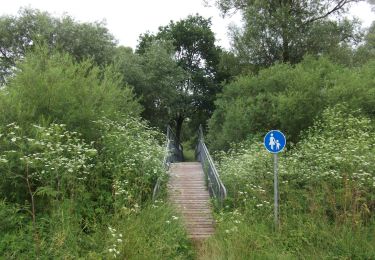
![](/images/other/stat-length.png)
![Tocht Te voet Neunkirchen a. Sand - Archäologischer Wanderweg Neunkirchen a. Sand - Photo](https://media.geolcdn.com/t/1900/400/4cd08f0e-1488-41f5-86e8-a39965dbd687.jpeg&format=pjpeg&maxdim=2)
Archäologischer Wanderweg Neunkirchen a. Sand
SityTrail - itinéraires balisés pédestres
Tous les sentiers balisés d’Europe GUIDE+
![Lengte](/images/other/stat-length.png)
![Max. hoogte](https://static1.geolcdn.com/siteimages/upload/files/1508320355ic_sort_altitude_max_24dp.png)
![Positief hoogteverschil](https://static1.geolcdn.com/siteimages/upload/files/1508320355ic_sort_den_pos_24dp.png)
![Km-Effort](/images/other/stat-length.png)
![Min. hoogte](https://static1.geolcdn.com/siteimages/upload/files/1508320355ic_sort_altitude_min_24dp.png)
![Negatief hoogteverschil](https://static1.geolcdn.com/siteimages/upload/files/1508320355ic_sort_den_neg_24dp.png)
![Boucle](https://static1.geolcdn.com/siteimages/upload/files/16400158638029165_repeat_loop_refresh_sync_direction_icon.png)
![Te voet](https://static1.geolcdn.com/sitytour/trail-icons/100.png)
2h03
Moeilijkheid : Gemakkelijk
![Scan deze QR-code om de tocht te openen in de SityTrail-applicatie](https://capi.geolives.com/qq0zvz2zws4bq2lad0pu/sitytour/trails/3088205/qr.png?size=200)
Gratisgps-wandelapplicatie
Over ons
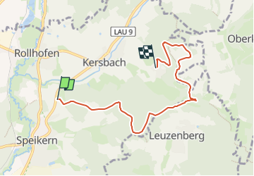
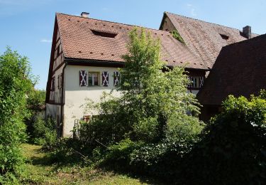
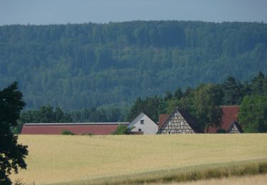
Tocht Te voet van 5,9 km beschikbaar op Beieren, Landkreis Nürnberger Land, Neunkirchen a. Sand. Deze tocht wordt voorgesteld door SityTrail - itinéraires balisés pédestres.
Beschrijving
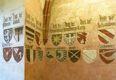
Trail created by Heimat- und Geschichtsverein Neunkirchen a. Sand.
geprüft (Feb. 2015, by cycling_zno)
Symbol: Steinzeitpferd mit Reiter in grünem Kreis
Plaatsbepaling
Opmerkingen
Wandeltochten in de omgeving
![Tocht Te voet Kirchensittenbach - Kirchensittenbach 4a - Photo](https://media.geolcdn.com/t/375/260/814dae09-5fb1-442e-abdf-4f3252bdd922.jpeg&format=jpg&maxdim=2)
![Te voet Te voet](https://static1.geolcdn.com/sitytour/trail-icons/100.png)
Te voet
![](/images/other/stat-length.png)
![](https://static1.geolcdn.com/siteimages/upload/files/16400158638029165_repeat_loop_refresh_sync_direction_icon.png)
![Tocht Te voet Kirchensittenbach - Kirchensittenbach 4 - Photo](https://media.geolcdn.com/t/375/260/143d5234-ad74-4965-bef0-21d79ad60f89.jpeg&format=jpg&maxdim=2)
![Te voet Te voet](https://static1.geolcdn.com/sitytour/trail-icons/100.png)
Te voet
![](/images/other/stat-length.png)
![](https://static1.geolcdn.com/siteimages/upload/files/16400158638029165_repeat_loop_refresh_sync_direction_icon.png)
![Tocht Te voet Kirchensittenbach - Oberkrumbach-Kleedorf - Photo](https://media.geolcdn.com/t/375/260/43473ef1-7005-47bb-9daa-75911118c670.jpeg&format=jpg&maxdim=2)
![Te voet Te voet](https://static1.geolcdn.com/sitytour/trail-icons/100.png)
Te voet
![](/images/other/stat-length.png)
![](https://static1.geolcdn.com/siteimages/upload/files/16400158638029165_repeat_loop_refresh_sync_direction_icon.png)
![Tocht Te voet Henfenfeld - Rundweg Henfenfeld – Reschenberg-Klosterberg-Pass - Photo](https://media.geolcdn.com/t/375/260/e0336b8f-eabb-4082-8864-c7d008328474.jpeg&format=jpg&maxdim=2)
![Te voet Te voet](https://static1.geolcdn.com/sitytour/trail-icons/100.png)
Te voet
![](/images/other/stat-length.png)
![](https://static1.geolcdn.com/siteimages/upload/files/16400158638029165_repeat_loop_refresh_sync_direction_icon.png)
![Tocht Te voet Henfenfeld - Rundweg Henfenfeld – Klosterberg - Photo](https://media.geolcdn.com/t/375/260/479f68cb-f7bf-44f8-8088-33053462fc3e.jpeg&format=jpg&maxdim=2)
![Te voet Te voet](https://static1.geolcdn.com/sitytour/trail-icons/100.png)
Te voet
![](/images/other/stat-length.png)
![](https://static1.geolcdn.com/siteimages/upload/files/16400158638029165_repeat_loop_refresh_sync_direction_icon.png)
![Tocht Te voet Lauf an der Pegnitz - Waldhaus-Runde - Photo](https://media.geolcdn.com/t/375/260/9a32beb1-5284-4a10-bf4e-1451730f92c2.jpeg&format=jpg&maxdim=2)
![Te voet Te voet](https://static1.geolcdn.com/sitytour/trail-icons/100.png)
Te voet
![](/images/other/stat-length.png)
![](https://static1.geolcdn.com/siteimages/upload/files/16400158638029165_repeat_loop_refresh_sync_direction_icon.png)
![Tocht Te voet Schönberg - Nessenbach-Runde - Photo](https://media.geolcdn.com/t/375/260/2b967ae6-761a-4b4d-b3f6-e8c432b699a5.jpeg&format=jpg&maxdim=2)
![Te voet Te voet](https://static1.geolcdn.com/sitytour/trail-icons/100.png)
Te voet
![](/images/other/stat-length.png)
![](https://static1.geolcdn.com/siteimages/upload/files/16400158638029165_repeat_loop_refresh_sync_direction_icon.png)
![Tocht Te voet Neunkirchen a. Sand - Schnaittachtalwanderweg - Photo](https://media.geolcdn.com/t/375/260/4b3ec6c1-e7fe-4b9a-890e-68e11ef3781c.jpeg&format=jpg&maxdim=2)
![Te voet Te voet](https://static1.geolcdn.com/sitytour/trail-icons/100.png)
Te voet
![](/images/other/stat-length.png)
![](https://static1.geolcdn.com/siteimages/upload/files/16400158638029165_repeat_loop_refresh_sync_direction_icon.png)
![Tocht Te voet Hersbruck - Hersbrucker Rundweg Nr. 7 - Photo](https://media.geolcdn.com/t/375/260/3f90c04b-a22d-4d62-a3e3-8492e771cc79.jpeg&format=jpg&maxdim=2)
![Te voet Te voet](https://static1.geolcdn.com/sitytour/trail-icons/100.png)
Te voet
![](/images/other/stat-length.png)
![](https://static1.geolcdn.com/siteimages/upload/files/16400158638029165_repeat_loop_refresh_sync_direction_icon.png)