![](/images/other/stat-length.png)
![Tocht Stappen Bédoin - Ste Colombe-Demoiselles Coiffées - Photo](https://media.geolcdn.com/t/1900/400/ae4096a2-8afc-4ed3-ac07-ca09b125e7e7.jpg&format=pjpeg&maxdim=2)
Ste Colombe-Demoiselles Coiffées
Manoune
Gebruiker
![Lengte](/images/other/stat-length.png)
![Max. hoogte](https://static1.geolcdn.com/siteimages/upload/files/1508320355ic_sort_altitude_max_24dp.png)
![Positief hoogteverschil](https://static1.geolcdn.com/siteimages/upload/files/1508320355ic_sort_den_pos_24dp.png)
![Km-Effort](/images/other/stat-length.png)
![Min. hoogte](https://static1.geolcdn.com/siteimages/upload/files/1508320355ic_sort_altitude_min_24dp.png)
![Negatief hoogteverschil](https://static1.geolcdn.com/siteimages/upload/files/1508320355ic_sort_den_neg_24dp.png)
![Boucle](https://static1.geolcdn.com/siteimages/upload/files/16400158638029165_repeat_loop_refresh_sync_direction_icon.png)
![Stappen](https://static1.geolcdn.com/sitytour/trail-icons/101.png)
5h22
Moeilijkheid : Moeilijk
![Scan deze QR-code om de tocht te openen in de SityTrail-applicatie](https://capi.geolives.com/qq0zvz2zws4bq2lad0pu/sitytour/trails/2807710/qr.png?size=200)
Gratisgps-wandelapplicatie
Over ons
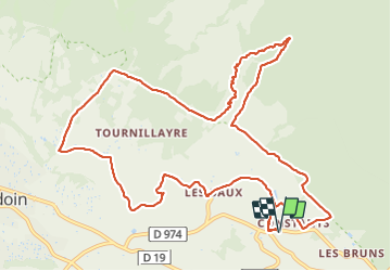
Tocht Stappen van 14,5 km beschikbaar op Provence-Alpes-Côte d'Azur, Vaucluse, Bédoin. Deze tocht wordt voorgesteld door Manoune.
Beschrijving
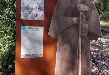
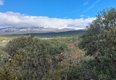
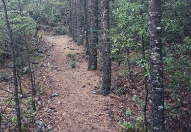
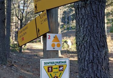
Départ du parking de Sainte Colombe (84) Cimetière, traversée du village des Baux, les Couguious, circuit dans le cite des Demoiselles Coiffées, Grange d'Allemand, les Sauviers, les Clops, GR 91 à droite, les Colombets, à gauche Combe de Curnier( beaucoup de pierres et passages étroits), au km 9, prendre à droite , grande descente, retrouver le Gr 91, les Bellons, les Fébriers, les Constants, cimetière et retour au parking. Bon courage.
Plaatsbepaling
Opmerkingen
Wandeltochten in de omgeving
![Tocht Stappen Bédoin - DEMOISELLES COIFFEES A BEDOIN - Photo](https://media.geolcdn.com/t/375/260/019fb321-209a-41dd-ae41-5842e06d9c3c.jpg&format=jpg&maxdim=2)
![Stappen Stappen](https://static1.geolcdn.com/sitytour/trail-icons/101.png)
Stappen
![](/images/other/stat-length.png)
![](https://static1.geolcdn.com/siteimages/upload/files/16400158638029165_repeat_loop_refresh_sync_direction_icon.png)
![Tocht Stappen Bédoin - Le Mont Ventoux en randonnée par Saint Colombe - Photo](https://media.geolcdn.com/t/375/260/ext.jpg?maxdim=2&url=https%3A%2F%2Fservices.sitytrail.com%2FGeolivesWS%2FDownloadMedia.ashx%3FTrailID%3D317282%26Media%3D16469_1.jpg)
![Stappen Stappen](https://static1.geolcdn.com/sitytour/trail-icons/101.png)
Stappen
![](/images/other/stat-length.png)
![](https://static1.geolcdn.com/siteimages/upload/files/16400158638029165_repeat_loop_refresh_sync_direction_icon.png)
![Tocht Stappen Mormoiron - Balladounette d après fêtes 🥳 - Photo](https://media.geolcdn.com/t/375/260/ecd5d04a-a53f-4421-b56c-9619fa1eb2e3.jpg&format=jpg&maxdim=2)
![Stappen Stappen](https://static1.geolcdn.com/sitytour/trail-icons/101.png)
Stappen
![](/images/other/stat-length.png)
![](https://static1.geolcdn.com/siteimages/upload/files/16400158638029165_repeat_loop_refresh_sync_direction_icon.png)
![Tocht Mountainbike Bédoin - Crillon Z'ensemble - Photo](https://media.geolcdn.com/t/375/260/9ac99583-ffb3-4a3d-a385-506d4b853f64.jpg&format=jpg&maxdim=2)
![Mountainbike Mountainbike](https://static1.geolcdn.com/sitytour/trail-icons/202.png)
Mountainbike
![](/images/other/stat-length.png)
![](https://static1.geolcdn.com/siteimages/upload/files/16400158638029165_repeat_loop_refresh_sync_direction_icon.png)
![Tocht Stappen Bédoin - Sur les traces du reboisement du Ventoux 1860 - Photo](https://media.geolcdn.com/t/375/260/fa234f56-c4fe-4d00-97d6-2ca9e6744a73.jpg&format=jpg&maxdim=2)
![Stappen Stappen](https://static1.geolcdn.com/sitytour/trail-icons/101.png)
Stappen
![](/images/other/stat-length.png)
![](https://static1.geolcdn.com/siteimages/upload/files/16400158638029165_repeat_loop_refresh_sync_direction_icon.png)
![Tocht Stappen Flassan - Sentiers sauvages de la Combe Ripert - Photo](https://media.geolcdn.com/t/375/260/93898e07-b925-4601-bf8c-4f651337a563.jpg&format=jpg&maxdim=2)
![Stappen Stappen](https://static1.geolcdn.com/sitytour/trail-icons/101.png)
Stappen
![](/images/other/stat-length.png)
![](https://static1.geolcdn.com/siteimages/upload/files/16400158638029165_repeat_loop_refresh_sync_direction_icon.png)
![Tocht Stappen Bédoin - Baume du Chat final par les Siarres - Photo](https://media.geolcdn.com/t/375/260/4fd782e1-4328-4855-b0d0-bdb9d12f34a6.jpg&format=jpg&maxdim=2)
![Stappen Stappen](https://static1.geolcdn.com/sitytour/trail-icons/101.png)
Stappen
![](/images/other/stat-length.png)
![](https://static1.geolcdn.com/siteimages/upload/files/16400158638029165_repeat_loop_refresh_sync_direction_icon.png)
![Tocht Stappen Flassan - La Cabane des chasseurs / Combe Ripert - Photo](https://media.geolcdn.com/t/375/260/89cf918a-a7cd-4cc9-8cda-73d8e6c3fda1.jpg&format=jpg&maxdim=2)
![Stappen Stappen](https://static1.geolcdn.com/sitytour/trail-icons/101.png)
Stappen
![](/images/other/stat-length.png)
![](https://static1.geolcdn.com/siteimages/upload/files/16400158638029165_repeat_loop_refresh_sync_direction_icon.png)
![Tocht Stappen Bédoin - Sur les Traces du Père Noël 🎅 - Photo](https://media.geolcdn.com/t/375/260/09583966-25c5-4863-b43d-4db2ee326b10.jpg&format=jpg&maxdim=2)
![Stappen Stappen](https://static1.geolcdn.com/sitytour/trail-icons/101.png)
Stappen
![](/images/other/stat-length.png)
![](https://static1.geolcdn.com/siteimages/upload/files/16400158638029165_repeat_loop_refresh_sync_direction_icon.png)