![](/images/other/stat-length.png)
![Tocht Noords wandelen Saint-Nizier-du-Moucherotte - St Nizier - Bois des Mures - Via Vercors 9 km - Photo](https://media.geolcdn.com/t/1900/400/102476ca-b880-4751-884c-8d4d9c8e3472.jpg&format=pjpeg&maxdim=2)
St Nizier - Bois des Mures - Via Vercors 9 km
patjobou
Gebruiker
![Lengte](/images/other/stat-length.png)
Lengte
9,2 km
![Max. hoogte](https://static1.geolcdn.com/siteimages/upload/files/1508320355ic_sort_altitude_max_24dp.png)
Max. hoogte
1306 m
![Positief hoogteverschil](https://static1.geolcdn.com/siteimages/upload/files/1508320355ic_sort_den_pos_24dp.png)
Positief hoogteverschil
349 m
![Km-Effort](/images/other/stat-length.png)
Km-Effort
13,8 km
![Min. hoogte](https://static1.geolcdn.com/siteimages/upload/files/1508320355ic_sort_altitude_min_24dp.png)
Min. hoogte
1053 m
![Negatief hoogteverschil](https://static1.geolcdn.com/siteimages/upload/files/1508320355ic_sort_den_neg_24dp.png)
Negatief hoogteverschil
350 m
![Boucle](https://static1.geolcdn.com/siteimages/upload/files/16400158638029165_repeat_loop_refresh_sync_direction_icon.png)
Boucle
Ja
Datum van aanmaak :
2018-09-04 06:49:19.259
Laatste wijziging :
2018-09-04 19:45:00.38
![Noords wandelen](https://static1.geolcdn.com/sitytour/trail-icons/102.png)
2h41
Moeilijkheid : Medium
![Scan deze QR-code om de tocht te openen in de SityTrail-applicatie](https://capi.geolives.com/qq0zvz2zws4bq2lad0pu/sitytour/trails/2009148/qr.png?size=200)
Gratisgps-wandelapplicatie
Over ons
Tocht Noords wandelen van 9,2 km beschikbaar op Auvergne-Rhône-Alpes, Isère, Saint-Nizier-du-Moucherotte. Deze tocht wordt voorgesteld door patjobou.
Beschrijving
Boucle intéressante en marche nordique. Seule la descente entre la piste du bois des mûres et la Via Vercors est un peu délicate, bien que sur une piste forestière, (raide).
Plaatsbepaling
Land:
France
Regio :
Auvergne-Rhône-Alpes
Departement/Provincie :
Isère
Gemeente :
Saint-Nizier-du-Moucherotte
Locatie:
Unknown
Vertrek:(Dec)
Vertrek:(UTM)
706686 ; 5005105 (31T) N.
Opmerkingen
Wandeltochten in de omgeving
![Tocht Stappen Sassenage - La ferme Durand - Photo](https://media.geolcdn.com/t/375/260/94c22489-8db0-4cec-b019-90eab5ac0fa3.jpg&format=jpg&maxdim=2)
![Stappen Stappen](https://static1.geolcdn.com/sitytour/trail-icons/101.png)
La ferme Durand
Stappen
Gemakkelijk
(2)
Sassenage,
Auvergne-Rhône-Alpes,
Isère,
France
![](/images/other/stat-length.png)
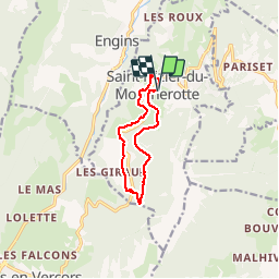
6,2 km | 13,3 km-effort
2h 7min
![](https://static1.geolcdn.com/siteimages/upload/files/16400158638029165_repeat_loop_refresh_sync_direction_icon.png)
Ja
![Tocht Noords wandelen Sassenage - Parc de l'Ovalie - Noyarey - Photo](https://media.geolcdn.com/t/375/260/d032ba44-c97c-4141-ba1d-c30342d72d38.jpg&format=jpg&maxdim=2)
![Noords wandelen Noords wandelen](https://static1.geolcdn.com/sitytour/trail-icons/102.png)
Parc de l'Ovalie - Noyarey
Noords wandelen
Gemakkelijk
(1)
Sassenage,
Auvergne-Rhône-Alpes,
Isère,
France
![](/images/other/stat-length.png)
11,8 km | 13 km-effort
2h 20min
![](https://static1.geolcdn.com/siteimages/upload/files/16400158638029165_repeat_loop_refresh_sync_direction_icon.png)
Neen
![Tocht Noords wandelen Seyssins - Seyssins le haut - Les Arcelles dans la neige - Photo](https://media.geolcdn.com/t/375/260/09832c62-e152-4e15-aea9-389ff5328b66.jpg&format=jpg&maxdim=2)
![Noords wandelen Noords wandelen](https://static1.geolcdn.com/sitytour/trail-icons/102.png)
Seyssins le haut - Les Arcelles dans la neige
Noords wandelen
Medium
(1)
Seyssins,
Auvergne-Rhône-Alpes,
Isère,
France
![](/images/other/stat-length.png)
9,1 km | 13,8 km-effort
2h 45min
![](https://static1.geolcdn.com/siteimages/upload/files/16400158638029165_repeat_loop_refresh_sync_direction_icon.png)
Ja
![Tocht Stappen Engins - Circuit pas de la Lose, du Tracollet, de l'Ours avec un retour par le passage de la Grande Combe - Photo](https://media.geolcdn.com/t/375/260/e578919b-c81c-4fe4-99cc-8260409f6f79.jpg&format=jpg&maxdim=2)
![Stappen Stappen](https://static1.geolcdn.com/sitytour/trail-icons/101.png)
Circuit pas de la Lose, du Tracollet, de l'Ours avec un retour par le passage...
Stappen
Medium
(3)
Engins,
Auvergne-Rhône-Alpes,
Isère,
France
![](/images/other/stat-length.png)
10,9 km | 21 km-effort
5h 12min
![](https://static1.geolcdn.com/siteimages/upload/files/16400158638029165_repeat_loop_refresh_sync_direction_icon.png)
Ja
![Tocht Stappen Seyssins - MOUCHEROTTE - Photo](https://media.geolcdn.com/t/375/260/fbc259ea-06fa-4a05-83ef-656dc650e275.jpg&format=jpg&maxdim=2)
![Stappen Stappen](https://static1.geolcdn.com/sitytour/trail-icons/101.png)
MOUCHEROTTE
Stappen
Moeilijk
(1)
Seyssins,
Auvergne-Rhône-Alpes,
Isère,
France
![](/images/other/stat-length.png)
20 km | 40 km-effort
8h 9min
![](https://static1.geolcdn.com/siteimages/upload/files/16400158638029165_repeat_loop_refresh_sync_direction_icon.png)
Ja
![Tocht Mountainbike Seyssins - Petite escapade électrique au-dessus de 38 Seyssins - Photo](https://media.geolcdn.com/t/375/260/68bfc982-e63d-4725-88db-1e4968c2728b.jpg&format=jpg&maxdim=2)
![Mountainbike Mountainbike](https://static1.geolcdn.com/sitytour/trail-icons/202.png)
Petite escapade électrique au-dessus de 38 Seyssins
Mountainbike
Gemakkelijk
(1)
Seyssins,
Auvergne-Rhône-Alpes,
Isère,
France
![](/images/other/stat-length.png)
12,3 km | 19,7 km-effort
1h 29min
![](https://static1.geolcdn.com/siteimages/upload/files/16400158638029165_repeat_loop_refresh_sync_direction_icon.png)
Ja
![Tocht Stappen Fontaine - M le 20 cabane de Laura - Photo](https://media.geolcdn.com/t/375/260/40be2dc6-e0ec-4dac-a44e-b55a1a5b0b08.jpg&format=jpg&maxdim=2)
![Stappen Stappen](https://static1.geolcdn.com/sitytour/trail-icons/101.png)
M le 20 cabane de Laura
Stappen
Moeilijk
(1)
Fontaine,
Auvergne-Rhône-Alpes,
Isère,
France
![](/images/other/stat-length.png)
16,8 km | 30 km-effort
6h 59min
![](https://static1.geolcdn.com/siteimages/upload/files/16400158638029165_repeat_loop_refresh_sync_direction_icon.png)
Ja
![Tocht Sneeuwschoenen Lans-en-Vercors - Charande, La Molière par les Aigaux - Photo](https://media.geolcdn.com/t/375/260/ext.jpg?maxdim=2&url=https%3A%2F%2Fservices.sitytrail.com%2FGeolivesWS%2FDownloadMedia.ashx%3FTrailID%3D518560%26Media%3Dfix__20160128112605.jpg)
![Sneeuwschoenen Sneeuwschoenen](https://static1.geolcdn.com/sitytour/trail-icons/504.png)
Charande, La Molière par les Aigaux
Sneeuwschoenen
Medium
(1)
Lans-en-Vercors,
Auvergne-Rhône-Alpes,
Isère,
France
![](/images/other/stat-length.png)
11,4 km | 18,8 km-effort
4h 30min
![](https://static1.geolcdn.com/siteimages/upload/files/16400158638029165_repeat_loop_refresh_sync_direction_icon.png)
Ja
![Tocht Lopen Seyssinet-Pariset - 19 mai - Photo](https://media.geolcdn.com/t/375/260/ext.jpg?maxdim=2&url=https%3A%2F%2Fservices.sitytrail.com%2FGeolivesWS%2FDownloadMedia.ashx%3FTrailID%3D128561%26Media%3D20120519101643.jpg)
![Lopen Lopen](https://static1.geolcdn.com/sitytour/trail-icons/103.png)
19 mai
Lopen
Heel gemakkelijk
(1)
Seyssinet-Pariset,
Auvergne-Rhône-Alpes,
Isère,
France
![](/images/other/stat-length.png)
5,7 km | 6,5 km-effort
1h 11min
![](https://static1.geolcdn.com/siteimages/upload/files/16400158638029165_repeat_loop_refresh_sync_direction_icon.png)
Ja