![](/images/other/stat-length.png)
![Tocht Stappen Ota - Ota - Barghiana - Photo](https://media.geolcdn.com/t/1900/400/ext.pjpeg?maxdim=2&url=https%3A%2F%2Fservices.sitytrail.com%2FGeolivesWS%2FDownloadMedia.ashx%3FTrailID%3D118841%26Media%3D13057_6.jpg)
Ota - Barghiana
tracegps
Gebruiker
![Lengte](/images/other/stat-length.png)
![Max. hoogte](https://static1.geolcdn.com/siteimages/upload/files/1508320355ic_sort_altitude_max_24dp.png)
![Positief hoogteverschil](https://static1.geolcdn.com/siteimages/upload/files/1508320355ic_sort_den_pos_24dp.png)
![Km-Effort](/images/other/stat-length.png)
![Min. hoogte](https://static1.geolcdn.com/siteimages/upload/files/1508320355ic_sort_altitude_min_24dp.png)
![Negatief hoogteverschil](https://static1.geolcdn.com/siteimages/upload/files/1508320355ic_sort_den_neg_24dp.png)
![Boucle](https://static1.geolcdn.com/siteimages/upload/files/16400158638029165_repeat_loop_refresh_sync_direction_icon.png)
![Stappen](https://static1.geolcdn.com/sitytour/trail-icons/101.png)
30h00
Moeilijkheid : Zeer moeilijk
![Scan deze QR-code om de tocht te openen in de SityTrail-applicatie](https://capi.geolives.com/qq0zvz2zws4bq2lad0pu/sitytour/trails/118841/qr.png?size=200)
Gratisgps-wandelapplicatie
Over ons
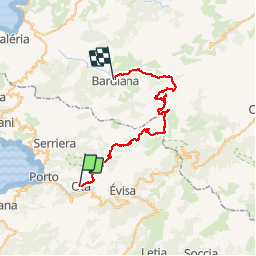
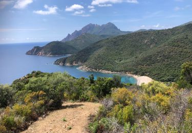
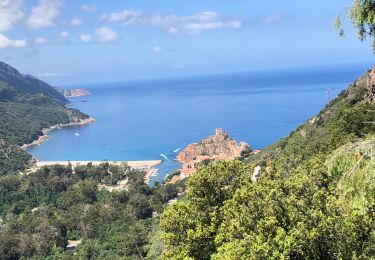
Tocht Stappen van 49 km beschikbaar op Corsica, Corse-du-Sud, Ota. Deze tocht wordt voorgesteld door tracegps.
Beschrijving
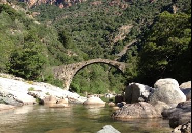
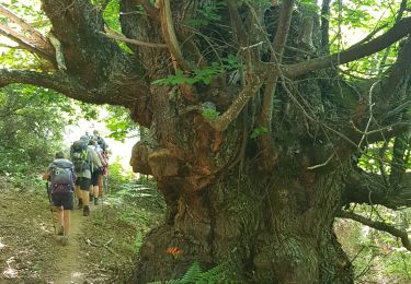
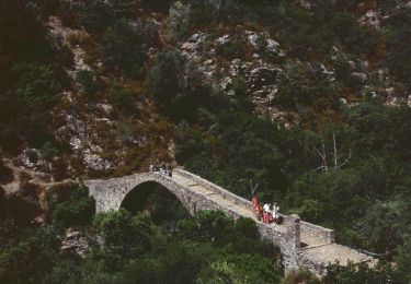
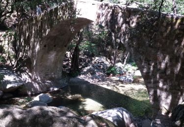
Ce trek relie Ota (près de Porto) à Barghiana (près de Galeria) en empruntant un itinéraire très original dans une des régions les plus sauvages de Corse. Il a été réalisé avec quatre bivouacs (Refuges de Puscaghia et de Ciottulu di i Mori, et nuits au pied du Tafunatu, et aux bergeries de Laoscella). Attention, si la trace GPS doit permettre de ne pas se perdre, quelques passages, sans être techniques, sont à la limite de la randonnée, d'autant plus qu'un sac à dos conséquent est nécessaire. Tous les détails sur cette page.
POI's
Plaatsbepaling
Opmerkingen
Wandeltochten in de omgeving
![Tocht Stappen Serriera - Mare e Monti - De Serriera à Ota - Photo](https://media.geolcdn.com/t/375/260/ext.jpg?maxdim=2&url=https%3A%2F%2Fservices.sitytrail.com%2FGeolivesWS%2FDownloadMedia.ashx%3FTrailID%3D109780%26Media%3D4710_1.jpg)
![Stappen Stappen](https://static1.geolcdn.com/sitytour/trail-icons/101.png)
Stappen
![](/images/other/stat-length.png)
![](https://static1.geolcdn.com/siteimages/upload/files/16400158638029165_repeat_loop_refresh_sync_direction_icon.png)
![Tocht Stappen Ota - Gorge de spelunca - Photo](https://media.geolcdn.com/t/375/260/f6804445-15a3-4e4f-812b-febb15caa6ee.jpg&format=jpg&maxdim=2)
![Stappen Stappen](https://static1.geolcdn.com/sitytour/trail-icons/101.png)
![Tocht Stappen Ota - gorges de la spelunca et pont, ota, corse - Photo](https://media.geolcdn.com/t/375/260/ext.jpg?maxdim=2&url=https%3A%2F%2Fservices.sitytrail.com%2FGeolivesWS%2FDownloadMedia.ashx%3FTrailID%3D209384%26Media%3D20130801094128.jpg)
![Stappen Stappen](https://static1.geolcdn.com/sitytour/trail-icons/101.png)
Stappen
![](/images/other/stat-length.png)
![](https://static1.geolcdn.com/siteimages/upload/files/16400158638029165_repeat_loop_refresh_sync_direction_icon.png)
![Tocht Stappen Ota - Ota Mariniana - Photo](https://media.geolcdn.com/t/375/260/b92651dc-1968-4d40-9564-f6b44744830a.jpg&format=jpg&maxdim=2)
![Stappen Stappen](https://static1.geolcdn.com/sitytour/trail-icons/101.png)
![Tocht Stappen Serriera - Serierra Ota - Photo](https://media.geolcdn.com/t/375/260/e7fdd3ae-25cd-4c33-9101-c2858a640faa.jpg&format=jpg&maxdim=2)
![Stappen Stappen](https://static1.geolcdn.com/sitytour/trail-icons/101.png)
Stappen
![](/images/other/stat-length.png)
![](https://static1.geolcdn.com/siteimages/upload/files/16400158638029165_repeat_loop_refresh_sync_direction_icon.png)
![Tocht Te voet Ota - Ota canyons - Photo](https://media.geolcdn.com/t/375/260/4dad7e61-defe-4494-9d4b-3248fec98a02.jpeg&format=jpg&maxdim=2)
![Te voet Te voet](https://static1.geolcdn.com/sitytour/trail-icons/100.png)
![Tocht Stappen Évisa - gorges spelunca - Photo](https://media.geolcdn.com/t/375/260/2ba82175-16ea-471a-af7d-9a429f43496d.jpg&format=jpg&maxdim=2)
![Stappen Stappen](https://static1.geolcdn.com/sitytour/trail-icons/101.png)
Stappen
![](/images/other/stat-length.png)
![](https://static1.geolcdn.com/siteimages/upload/files/16400158638029165_repeat_loop_refresh_sync_direction_icon.png)
![Tocht Stappen Serriera - 20210608 Serriera - Gradelle - Photo](https://media.geolcdn.com/t/375/260/ea9dba27-4698-47fa-9b83-768439d3b81a.jpg&format=jpg&maxdim=2)
![Stappen Stappen](https://static1.geolcdn.com/sitytour/trail-icons/101.png)
Stappen
![](/images/other/stat-length.png)
![](https://static1.geolcdn.com/siteimages/upload/files/16400158638029165_repeat_loop_refresh_sync_direction_icon.png)
![Tocht Stappen Ota - 20210607 de Otta a Bussaghia- balcons de Porto - Photo](https://media.geolcdn.com/t/375/260/3d6c3fdf-cc74-4e9a-ba21-7c75e8e28103.jpg&format=jpg&maxdim=2)
![Stappen Stappen](https://static1.geolcdn.com/sitytour/trail-icons/101.png)
Stappen
![](/images/other/stat-length.png)
![](https://static1.geolcdn.com/siteimages/upload/files/16400158638029165_repeat_loop_refresh_sync_direction_icon.png)