![](/images/other/stat-length.png)
- Tochten
- Te voet
- Germany
- Rijnland-Palts
- Rhein-Lahn-Kreis
Rhein-Lahn-Kreis, Rijnland-Palts, Te voet: Top van de beste wandelroutes, trajecten, tochten en wandelingen
Rhein-Lahn-Kreis: Ontdek de beste tochten: 64 te voet en 2 stappen. Al deze tochten, trajecten, routes en outdoor activiteiten zijn beschikbaar in onze SityTrail-apps voor smartphones en tablets.
De beste trajecten (66)
![Tocht Te voet Lahnstein - Rundwanderweg A - Photo](https://media.geolcdn.com/t/350/260/b3ba714d-2c3e-4a80-887e-6fcddb8584ce.jpeg&format=jpg&maxdim=2)
![Te voet Te voet](https://static1.geolcdn.com/sitytour/trail-icons/100.png)
Km
Te voet
![](/images/other/stat-length.png)
![](https://static1.geolcdn.com/siteimages/upload/files/1508320355ic_sort_den_pos_24dp.png)
![](https://static1.geolcdn.com/siteimages/upload/files/1508320355ic_sort_den_neg_24dp.png)
![](https://static1.geolcdn.com/siteimages/upload/files/16400158638029165_repeat_loop_refresh_sync_direction_icon.png)
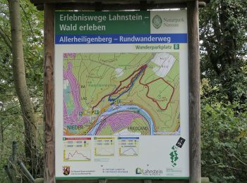
• Trail created by Forstamt Lahnstein - Forstrevier Lahnstein. Symbol: gelbes "A" auf weißem Grund
![Tocht Te voet Lahnstein - Rundwanderweg B - Photo](https://media.geolcdn.com/t/350/260/35ccf662-4335-4af1-a7ec-7cb0f2ffa796.jpeg&format=jpg&maxdim=2)
![Te voet Te voet](https://static1.geolcdn.com/sitytour/trail-icons/100.png)
Km
Te voet
![](/images/other/stat-length.png)
![](https://static1.geolcdn.com/siteimages/upload/files/1508320355ic_sort_den_pos_24dp.png)
![](https://static1.geolcdn.com/siteimages/upload/files/1508320355ic_sort_den_neg_24dp.png)
![](https://static1.geolcdn.com/siteimages/upload/files/16400158638029165_repeat_loop_refresh_sync_direction_icon.png)
• Trail created by Forstamt Lahnstein - Forstrevier Spiessborn. Symbol: rotes "B" auf weißem Grund
![Tocht Te voet Patersberg - Rheinsteig-Zuweg Reichenberg - Photo](https://media.geolcdn.com/t/350/260/218cc5e6-bd20-4d49-9cb7-475262efda6d.jpeg&format=jpg&maxdim=2)
![Te voet Te voet](https://static1.geolcdn.com/sitytour/trail-icons/100.png)
Km
Te voet
![](/images/other/stat-length.png)
![](https://static1.geolcdn.com/siteimages/upload/files/1508320355ic_sort_den_pos_24dp.png)
![](https://static1.geolcdn.com/siteimages/upload/files/1508320355ic_sort_den_neg_24dp.png)
![](https://static1.geolcdn.com/siteimages/upload/files/16400158638029165_repeat_loop_refresh_sync_direction_icon.png)
• Trail created by Romantischer Rhein Tourismus GmbH. Symbol: Stilisiertes weißes R auf gelbem Grund
![Tocht Te voet Sankt Goarshausen - Rheinsteig-Zuweg Nochem - Photo](https://media.geolcdn.com/t/350/260/3f5191fc-70ef-45e0-a9cd-2f36cd7a53a2.jpeg&format=jpg&maxdim=2)
![Te voet Te voet](https://static1.geolcdn.com/sitytour/trail-icons/100.png)
Km
Te voet
![](/images/other/stat-length.png)
![](https://static1.geolcdn.com/siteimages/upload/files/1508320355ic_sort_den_pos_24dp.png)
![](https://static1.geolcdn.com/siteimages/upload/files/1508320355ic_sort_den_neg_24dp.png)
![](https://static1.geolcdn.com/siteimages/upload/files/16400158638029165_repeat_loop_refresh_sync_direction_icon.png)
• Trail created by Romantischer Rhein Tourismus GmbH. Symbol: Stilisiertes weißes R auf gelbem Grund
![Tocht Te voet Osterspai - Rheinsteig-Zuweg Osterspai - Photo](https://media.geolcdn.com/t/350/260/f6f75fe7-a4a6-44b5-af45-6efbc94565f7.jpeg&format=jpg&maxdim=2)
![Te voet Te voet](https://static1.geolcdn.com/sitytour/trail-icons/100.png)
Km
Te voet
![](/images/other/stat-length.png)
![](https://static1.geolcdn.com/siteimages/upload/files/1508320355ic_sort_den_pos_24dp.png)
![](https://static1.geolcdn.com/siteimages/upload/files/1508320355ic_sort_den_neg_24dp.png)
![](https://static1.geolcdn.com/siteimages/upload/files/16400158638029165_repeat_loop_refresh_sync_direction_icon.png)
• Trail created by Romantischer Rhein Tourismus GmbH. Symbol: Stilisiertes weißes R auf gelbem Grund
![Tocht Te voet Lahnstein - Rheinsteig-Exkursion Spießborner Grillhütte - Photo](https://media.geolcdn.com/t/350/260/b2377cd6-e4ec-4606-b2af-383b46dde74f.jpeg&format=jpg&maxdim=2)
![Te voet Te voet](https://static1.geolcdn.com/sitytour/trail-icons/100.png)
Km
Te voet
![](/images/other/stat-length.png)
![](https://static1.geolcdn.com/siteimages/upload/files/1508320355ic_sort_den_pos_24dp.png)
![](https://static1.geolcdn.com/siteimages/upload/files/1508320355ic_sort_den_neg_24dp.png)
![](https://static1.geolcdn.com/siteimages/upload/files/16400158638029165_repeat_loop_refresh_sync_direction_icon.png)
• Trail created by Romantischer Rhein Tourismus GmbH. Symbol: Stilisiertes weißes R auf gelbem Grund
![Tocht Te voet Braubach - Rundwanderweg Buchenweg Braubach - Photo](https://media.geolcdn.com/t/350/260/c27dfe35-82f6-4c02-82d8-7abf0a82d086.jpeg&format=jpg&maxdim=2)
![Te voet Te voet](https://static1.geolcdn.com/sitytour/trail-icons/100.png)
Km
Te voet
![](/images/other/stat-length.png)
![](https://static1.geolcdn.com/siteimages/upload/files/1508320355ic_sort_den_pos_24dp.png)
![](https://static1.geolcdn.com/siteimages/upload/files/1508320355ic_sort_den_neg_24dp.png)
![](https://static1.geolcdn.com/siteimages/upload/files/16400158638029165_repeat_loop_refresh_sync_direction_icon.png)
• Symbol: Hellgrünes aufrechtstehendes Buchenblatt mit Stiel
![Tocht Te voet Frücht - Freiherr-vom-Stein-Pfad - Photo](https://media.geolcdn.com/t/350/260/8dc459cf-928b-48f9-926a-d602c9df1b13.jpeg&format=jpg&maxdim=2)
![Te voet Te voet](https://static1.geolcdn.com/sitytour/trail-icons/100.png)
Km
Te voet
![](/images/other/stat-length.png)
![](https://static1.geolcdn.com/siteimages/upload/files/1508320355ic_sort_den_pos_24dp.png)
![](https://static1.geolcdn.com/siteimages/upload/files/1508320355ic_sort_den_neg_24dp.png)
![](https://static1.geolcdn.com/siteimages/upload/files/16400158638029165_repeat_loop_refresh_sync_direction_icon.png)
• Symbol: blaues "FSP" auf weißem Grund.
![Tocht Te voet Lahnstein - Wanderweg Forsthaus-Weg FH - Photo](https://media.geolcdn.com/t/350/260/2e641572-c4cb-481d-ba84-577c334c6fad.jpeg&format=jpg&maxdim=2)
![Te voet Te voet](https://static1.geolcdn.com/sitytour/trail-icons/100.png)
Km
Te voet
![](/images/other/stat-length.png)
![](https://static1.geolcdn.com/siteimages/upload/files/1508320355ic_sort_den_pos_24dp.png)
![](https://static1.geolcdn.com/siteimages/upload/files/1508320355ic_sort_den_neg_24dp.png)
![](https://static1.geolcdn.com/siteimages/upload/files/16400158638029165_repeat_loop_refresh_sync_direction_icon.png)
• Trail created by Forstamt Lahnstein - Forstrevier Spiessborn. Symbol: gelbes "FH" auf weißem Grund
![Tocht Te voet Lahnstein - Rundwanderweg Braubach: B2 Kerkerts-Pickert-Mühltal - Photo](https://media.geolcdn.com/t/350/260/796bd870-e05e-4ab5-8f33-3b442e1e4672.jpeg&format=jpg&maxdim=2)
![Te voet Te voet](https://static1.geolcdn.com/sitytour/trail-icons/100.png)
Km
Te voet
![](/images/other/stat-length.png)
![](https://static1.geolcdn.com/siteimages/upload/files/1508320355ic_sort_den_pos_24dp.png)
![](https://static1.geolcdn.com/siteimages/upload/files/1508320355ic_sort_den_neg_24dp.png)
![](https://static1.geolcdn.com/siteimages/upload/files/16400158638029165_repeat_loop_refresh_sync_direction_icon.png)
• Trail created by Forstrevier Braubach - Forstamt Lahnstein. Symbol: rotes "B2" auf weißem Grund.
![Tocht Te voet Lahnstein - Rundwanderweg Braubach: B3 Kleinbahndamm-Hinterwald-Molkenborn - Photo](https://media.geolcdn.com/t/350/260/7b23eb30-2a7b-4a85-b645-52dbc1235be2.jpeg&format=jpg&maxdim=2)
![Te voet Te voet](https://static1.geolcdn.com/sitytour/trail-icons/100.png)
Km
Te voet
![](/images/other/stat-length.png)
![](https://static1.geolcdn.com/siteimages/upload/files/1508320355ic_sort_den_pos_24dp.png)
![](https://static1.geolcdn.com/siteimages/upload/files/1508320355ic_sort_den_neg_24dp.png)
![](https://static1.geolcdn.com/siteimages/upload/files/16400158638029165_repeat_loop_refresh_sync_direction_icon.png)
• Trail created by Forstrevier Braubach - Forstamt Lahnstein. Symbol: rotes "B3" auf weißem Grund.
![Tocht Te voet Frücht - Panorama-Rundweg - Frücht - Photo](https://media.geolcdn.com/t/350/260/e7cbbde3-aa0d-4b82-9f70-daea77753be9.jpeg&format=jpg&maxdim=2)
![Te voet Te voet](https://static1.geolcdn.com/sitytour/trail-icons/100.png)
Km
Te voet
![](/images/other/stat-length.png)
![](https://static1.geolcdn.com/siteimages/upload/files/1508320355ic_sort_den_pos_24dp.png)
![](https://static1.geolcdn.com/siteimages/upload/files/1508320355ic_sort_den_neg_24dp.png)
![](https://static1.geolcdn.com/siteimages/upload/files/16400158638029165_repeat_loop_refresh_sync_direction_icon.png)
• Symbol: gelbes "PRF" auf weißem Grund.
![Tocht Te voet Lahnstein - Rundwanderweg A2 - Photo](https://media.geolcdn.com/t/350/260/619ec1e9-d3a9-42cb-9013-c11b363c7d0e.jpeg&format=jpg&maxdim=2)
![Te voet Te voet](https://static1.geolcdn.com/sitytour/trail-icons/100.png)
Km
Te voet
![](/images/other/stat-length.png)
![](https://static1.geolcdn.com/siteimages/upload/files/1508320355ic_sort_den_pos_24dp.png)
![](https://static1.geolcdn.com/siteimages/upload/files/1508320355ic_sort_den_neg_24dp.png)
![](https://static1.geolcdn.com/siteimages/upload/files/16400158638029165_repeat_loop_refresh_sync_direction_icon.png)
• Trail created by Forstamt Lahnstein - Forstrevier Lahnstein. Symbol: blaues "A2" auf weißem Grund
![Tocht Te voet Lahnstein - Rundwanderweg B2 - Photo](https://media.geolcdn.com/t/350/260/35ccf662-4335-4af1-a7ec-7cb0f2ffa796.jpeg&format=jpg&maxdim=2)
![Te voet Te voet](https://static1.geolcdn.com/sitytour/trail-icons/100.png)
Km
Te voet
![](/images/other/stat-length.png)
![](https://static1.geolcdn.com/siteimages/upload/files/1508320355ic_sort_den_pos_24dp.png)
![](https://static1.geolcdn.com/siteimages/upload/files/1508320355ic_sort_den_neg_24dp.png)
![](https://static1.geolcdn.com/siteimages/upload/files/16400158638029165_repeat_loop_refresh_sync_direction_icon.png)
• Trail created by Forstamt Lahnstein - Forstrevier Spiessborn. Symbol: blaues "B2" auf weißem Grund
![Tocht Te voet Lahnstein - Rundwanderweg B1 - Photo](https://media.geolcdn.com/t/350/260/80aeb201-bc00-46e6-b6ee-506c4a07069c.jpeg&format=jpg&maxdim=2)
![Te voet Te voet](https://static1.geolcdn.com/sitytour/trail-icons/100.png)
Km
Te voet
![](/images/other/stat-length.png)
![](https://static1.geolcdn.com/siteimages/upload/files/1508320355ic_sort_den_pos_24dp.png)
![](https://static1.geolcdn.com/siteimages/upload/files/1508320355ic_sort_den_neg_24dp.png)
![](https://static1.geolcdn.com/siteimages/upload/files/16400158638029165_repeat_loop_refresh_sync_direction_icon.png)
• Trail created by Forstamt Lahnstein - Forstrevier Spiessborn. Symbol: gelbes "B1" auf weißem Grund
![Tocht Te voet Lahnstein - Rundwanderweg D1 - Photo](https://media.geolcdn.com/t/350/260/b2377cd6-e4ec-4606-b2af-383b46dde74f.jpeg&format=jpg&maxdim=2)
![Te voet Te voet](https://static1.geolcdn.com/sitytour/trail-icons/100.png)
Km
Te voet
![](/images/other/stat-length.png)
![](https://static1.geolcdn.com/siteimages/upload/files/1508320355ic_sort_den_pos_24dp.png)
![](https://static1.geolcdn.com/siteimages/upload/files/1508320355ic_sort_den_neg_24dp.png)
![](https://static1.geolcdn.com/siteimages/upload/files/16400158638029165_repeat_loop_refresh_sync_direction_icon.png)
• Trail created by Forstamt Lahnstein - Forstrevier Lahnstein. Symbol: orangenes "D1" auf weißem Grund
![Tocht Te voet Lahnstein - Rundwanderweg F4 - Photo](https://media.geolcdn.com/t/350/260/2e641572-c4cb-481d-ba84-577c334c6fad.jpeg&format=jpg&maxdim=2)
![Te voet Te voet](https://static1.geolcdn.com/sitytour/trail-icons/100.png)
Km
Te voet
![](/images/other/stat-length.png)
![](https://static1.geolcdn.com/siteimages/upload/files/1508320355ic_sort_den_pos_24dp.png)
![](https://static1.geolcdn.com/siteimages/upload/files/1508320355ic_sort_den_neg_24dp.png)
![](https://static1.geolcdn.com/siteimages/upload/files/16400158638029165_repeat_loop_refresh_sync_direction_icon.png)
• Trail created by Forstamt Lahnstein - Forstrevier Spiessborn. Symbol: schwarzes "F4" auf weißem Grund
![Tocht Te voet Lahnstein - Rundwanderweg F2 - Photo](https://media.geolcdn.com/t/350/260/2e641572-c4cb-481d-ba84-577c334c6fad.jpeg&format=jpg&maxdim=2)
![Te voet Te voet](https://static1.geolcdn.com/sitytour/trail-icons/100.png)
Km
Te voet
![](/images/other/stat-length.png)
![](https://static1.geolcdn.com/siteimages/upload/files/1508320355ic_sort_den_pos_24dp.png)
![](https://static1.geolcdn.com/siteimages/upload/files/1508320355ic_sort_den_neg_24dp.png)
![](https://static1.geolcdn.com/siteimages/upload/files/16400158638029165_repeat_loop_refresh_sync_direction_icon.png)
• Trail created by Forstamt Lahnstein - Forstrevier Spiessborn. Die Route des F2's wurde 2020 geändert, der neue F2 is...
![Tocht Te voet Lykershausen - Rheinsteig-Zuweg Prath - Photo](https://media.geolcdn.com/t/350/260/2dd86e25-590e-4ec6-a0d2-8759287d411e.jpeg&format=jpg&maxdim=2)
![Te voet Te voet](https://static1.geolcdn.com/sitytour/trail-icons/100.png)
Km
Te voet
![](/images/other/stat-length.png)
![](https://static1.geolcdn.com/siteimages/upload/files/1508320355ic_sort_den_pos_24dp.png)
![](https://static1.geolcdn.com/siteimages/upload/files/1508320355ic_sort_den_neg_24dp.png)
![](https://static1.geolcdn.com/siteimages/upload/files/16400158638029165_repeat_loop_refresh_sync_direction_icon.png)
• Trail created by Romantischer Rhein Tourismus GmbH. Symbol: Stilisiertes weißes R auf gelbem Grund
![Tocht Te voet Braubach - Rundwanderweg Braubach: B1 Kerkerts-Oberhohl-Schlierbachtal - Photo](https://media.geolcdn.com/t/350/260/a243512b-c818-48e4-9ce7-76c3d40ba99c.jpeg&format=jpg&maxdim=2)
![Te voet Te voet](https://static1.geolcdn.com/sitytour/trail-icons/100.png)
Km
Te voet
![](/images/other/stat-length.png)
![](https://static1.geolcdn.com/siteimages/upload/files/1508320355ic_sort_den_pos_24dp.png)
![](https://static1.geolcdn.com/siteimages/upload/files/1508320355ic_sort_den_neg_24dp.png)
![](https://static1.geolcdn.com/siteimages/upload/files/16400158638029165_repeat_loop_refresh_sync_direction_icon.png)
• Trail created by Forstrevier Braubach - Forstamt Lahnstein. Symbol: blaues "B1" auf weißem Grund.
20 tochten weergegeven op 66
Gratisgps-wandelapplicatie