![](/images/other/stat-length.png)
![Randonnée Marche nordique Saint-Georges-d'Oléron - Marais du Douhet - Photo](https://media.geolcdn.com/t/1900/400/ext.pjpeg?maxdim=2&url=https%3A%2F%2Fstatic1.geolcdn.com%2Fsiteimages%2Fupload%2Ffiles%2F1545311037marcheuse_200dpi.jpg)
Marais du Douhet
dmatignon
Utilisateur
![Longueur](/images/other/stat-length.png)
Longueur
10,1 km
![Altitude max](https://static1.geolcdn.com/siteimages/upload/files/1508320355ic_sort_altitude_max_24dp.png)
Altitude max
12 m
![Dénivelé positif](https://static1.geolcdn.com/siteimages/upload/files/1508320355ic_sort_den_pos_24dp.png)
Dénivelé positif
33 m
![Km-Effort](/images/other/stat-length.png)
Km-Effort
10,6 km
![Altitude min](https://static1.geolcdn.com/siteimages/upload/files/1508320355ic_sort_altitude_min_24dp.png)
Altitude min
-2 m
![Dénivelé négatif](https://static1.geolcdn.com/siteimages/upload/files/1508320355ic_sort_den_neg_24dp.png)
Dénivelé négatif
33 m
![Boucle](https://static1.geolcdn.com/siteimages/upload/files/16400158638029165_repeat_loop_refresh_sync_direction_icon.png)
Boucle
Non
Date de création :
2018-06-26 15:32:18.049
Dernière modification :
2018-06-26 15:32:18.049
![Marche nordique](https://static1.geolcdn.com/sitytour/trail-icons/102.png)
1h45
Difficulté : Facile
![Scannez ce code QR pour ouvrir la randonnée dans l'application SityTrail](https://capi.geolives.com/qq0zvz2zws4bq2lad0pu/sitytour/trails/979595/qr.png?size=200)
Application GPS de randonnée GRATUITE
À propos
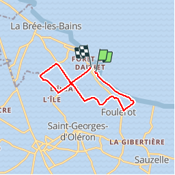
Randonnée Marche nordique de 10,1 km à découvrir à Nouvelle-Aquitaine, Charente-Maritime, Saint-Georges-d'Oléron. Cette randonnée est proposée par dmatignon.
Description
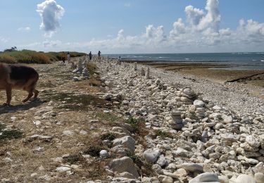
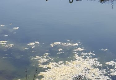
Boucle de marche nordique au départ du port du Douhet.
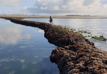
De la plage au départ, puis passage dans les marais.
Nécessite des embouts en caoutchouc.
Localisation
Pays :
France
Région :
Nouvelle-Aquitaine
Département/Province :
Charente-Maritime
Commune :
Saint-Georges-d'Oléron
Localité :
Unknown
Départ:(Dec)
Départ:(UTM)
629875 ; 5095422 (30T) N.
Commentaires
Randonnées à proximité
![Randonnée Marche Saint-Denis-d'Oléron - st Denis Oleron boucle - Photo](https://media.geolcdn.com/t/375/260/ext.jpg?maxdim=2&url=https%3A%2F%2Fstatic1.geolcdn.com%2Fsiteimages%2Fupload%2Ffiles%2F1553511878bg_sport_marche.png)
![Marche Marche](https://static1.geolcdn.com/sitytour/trail-icons/101.png)
st Denis Oleron boucle
Marche
Très facile
(1)
Saint-Denis-d'Oléron,
Nouvelle-Aquitaine,
Charente-Maritime,
France
![](/images/other/stat-length.png)
12,6 km | 13,3 km-effort
3h 10min
![](https://static1.geolcdn.com/siteimages/upload/files/16400158638029165_repeat_loop_refresh_sync_direction_icon.png)
Oui
![Randonnée Marche Saint-Denis-d'Oléron - La Gautrie 26 octobre 2021 - Photo](https://media.geolcdn.com/t/375/260/715bfe94-45fe-44aa-aecd-0e31f90463b9.jpg&format=jpg&maxdim=2)
![Marche Marche](https://static1.geolcdn.com/sitytour/trail-icons/101.png)
La Gautrie 26 octobre 2021
Marche
Moyen
Saint-Denis-d'Oléron,
Nouvelle-Aquitaine,
Charente-Maritime,
France
![](/images/other/stat-length.png)
11 km | 11,4 km-effort
4h 35min
![](https://static1.geolcdn.com/siteimages/upload/files/16400158638029165_repeat_loop_refresh_sync_direction_icon.png)
Oui
![Randonnée V.T.T. Saint-Georges-d'Oléron - 12092013 - Photo](https://media.geolcdn.com/t/375/260/ext.jpg?maxdim=2&url=https%3A%2F%2Fservices.sitytrail.com%2FGeolivesWS%2FDownloadMedia.ashx%3FTrailID%3D220725%26Media%3Dfix__20130912110800.jpg)
![V.T.T. V.T.T.](https://static1.geolcdn.com/sitytour/trail-icons/202.png)
12092013
V.T.T.
Facile
Saint-Georges-d'Oléron,
Nouvelle-Aquitaine,
Charente-Maritime,
France
![](/images/other/stat-length.png)
90 km | 95 km-effort
4h 30min
![](https://static1.geolcdn.com/siteimages/upload/files/16400158638029165_repeat_loop_refresh_sync_direction_icon.png)
Oui
![Randonnée Marche Saint-Georges-d'Oléron - domino - Photo](https://media.geolcdn.com/t/375/260/e5423c97-cceb-4912-8f52-9c9f999bbd44.jpg&format=jpg&maxdim=2)
![Marche Marche](https://static1.geolcdn.com/sitytour/trail-icons/101.png)
domino
Marche
Facile
Saint-Georges-d'Oléron,
Nouvelle-Aquitaine,
Charente-Maritime,
France
![](/images/other/stat-length.png)
7,4 km | 8,3 km-effort
2h 31min
![](https://static1.geolcdn.com/siteimages/upload/files/16400158638029165_repeat_loop_refresh_sync_direction_icon.png)
Oui
![Randonnée Marche Saint-Denis-d'Oléron - chassieon - Photo](https://media.geolcdn.com/t/375/260/245a2c97-e53d-40e4-b0c9-1dc91aa0fed3.jpg&format=jpg&maxdim=2)
![Marche Marche](https://static1.geolcdn.com/sitytour/trail-icons/101.png)
chassieon
Marche
Difficile
Saint-Denis-d'Oléron,
Nouvelle-Aquitaine,
Charente-Maritime,
France
![](/images/other/stat-length.png)
12 km | 12,7 km-effort
3h 17min
![](https://static1.geolcdn.com/siteimages/upload/files/16400158638029165_repeat_loop_refresh_sync_direction_icon.png)
Oui
![Randonnée Marche Saint-Denis-d'Oléron - Les Huttes - Photo](https://media.geolcdn.com/t/375/260/195e502b-8e8a-40af-b5da-3c6e4ab17699.jpg&format=jpg&maxdim=2)
![Marche Marche](https://static1.geolcdn.com/sitytour/trail-icons/101.png)
Les Huttes
Marche
Difficile
Saint-Denis-d'Oléron,
Nouvelle-Aquitaine,
Charente-Maritime,
France
![](/images/other/stat-length.png)
13,2 km | 14,1 km-effort
3h 41min
![](https://static1.geolcdn.com/siteimages/upload/files/16400158638029165_repeat_loop_refresh_sync_direction_icon.png)
Non
![Randonnée Marche Saint-Georges-d'Oléron - sables viguier - Photo](https://media.geolcdn.com/t/375/260/93ed052a-50b4-4459-95ce-f424f03253af.jpg&format=jpg&maxdim=2)
![Marche Marche](https://static1.geolcdn.com/sitytour/trail-icons/101.png)
sables viguier
Marche
Très facile
Saint-Georges-d'Oléron,
Nouvelle-Aquitaine,
Charente-Maritime,
France
![](/images/other/stat-length.png)
13,7 km | 14,7 km-effort
2h 48min
![](https://static1.geolcdn.com/siteimages/upload/files/16400158638029165_repeat_loop_refresh_sync_direction_icon.png)
Non
![Randonnée V.T.C. Saint-Georges-d'Oléron - 17 Boucle depuis la plage de plaisir à Chassiron - Photo](https://media.geolcdn.com/t/375/260/7c98f3e2-2135-4531-b65a-49d62c7893a6.jpg&format=jpg&maxdim=2)
![V.T.C. V.T.C.](https://static1.geolcdn.com/sitytour/trail-icons/203.png)
17 Boucle depuis la plage de plaisir à Chassiron
V.T.C.
Très facile
Saint-Georges-d'Oléron,
Nouvelle-Aquitaine,
Charente-Maritime,
France
![](/images/other/stat-length.png)
30 km | 32 km-effort
2h 15min
![](https://static1.geolcdn.com/siteimages/upload/files/16400158638029165_repeat_loop_refresh_sync_direction_icon.png)
Oui
![Randonnée V.T.C. Saint-Georges-d'Oléron - 17 St Georges d Oléron/forêt des Saumonards - Photo](https://media.geolcdn.com/t/375/260/e09323c8-75b4-43b2-87bd-e7d4a486bd61.jpg&format=jpg&maxdim=2)
![V.T.C. V.T.C.](https://static1.geolcdn.com/sitytour/trail-icons/203.png)
17 St Georges d Oléron/forêt des Saumonards
V.T.C.
Très facile
Saint-Georges-d'Oléron,
Nouvelle-Aquitaine,
Charente-Maritime,
France
![](/images/other/stat-length.png)
24 km | 26 km-effort
2h 0min
![](https://static1.geolcdn.com/siteimages/upload/files/16400158638029165_repeat_loop_refresh_sync_direction_icon.png)
Oui