Randonnée Marche Mittlach - Mittlach, Lac d'Altenweiher, Vallée de la  Wormsa - Photo

Mittlach, Lac d'Altenweiher, Vallée de la Wormsa

 oscar1
oscar1

Utilisateur

© OpenStreetMap contributors
Longueur
Longueur
12,7 km
Altitude max
Altitude max
1088 m
Dénivelé positif
Dénivelé positif
635 m
Km-Effort
Km-Effort  
21 km
Altitude min
Altitude min
524 m
Dénivelé négatif
Dénivelé négatif
636 m
Boucle
Boucle
Oui
Date de création :
2018-04-17 23:53:14.884
Dernière modification :
2019-02-09 23:44:15.775

(1 Avis)

Marche
Marche
6h00
Difficulté : Inconnu

Scannez ce code QR pour ouvrir la randonnée dans l'application SityTrail

Application GPS de randonnée GRATUITE

Logo SityTrail SityTrail

IGN / Instituts géographiques

Télécharger SityTrail sur l'App Store Télécharger SityTrail sur Google Play

Logo SityTrail SityTrail World

Le monde est à vous

Télécharger SityTrail sur l'App Store Télécharger SityTrail sur Google Play Télécharger SityTrail sur Huawei AppGallery

À propos

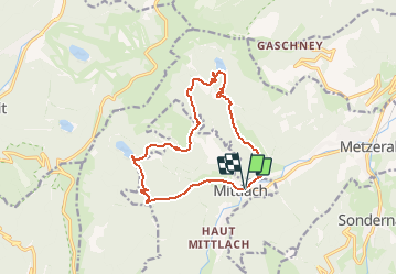
Randonnée Marche de 12,7 km à découvrir à Grand Est, Haut-Rhin, Mittlach. Cette randonnée est proposée par oscar1.

Description

Randonnée pour bon marcheur.

Profil altimétrique

Localisation

Pays :
France
Région :
Grand Est
Département/Province :
Haut-Rhin
Commune :
Mittlach
Localité :
Unknown
Départ:(Dec)
Départ:(UTM)
353277 ; 5318634 (32U) N.

Commentaires

Veuillez vous connecter pour laisser un commentaire ou une note


Randonnées à proximité

Randonnée Marche La Bresse - 2023-04-16 Marche Abri Lac de Blanchemer vers Lac de Lispach - Photo
Marche
GUIDE
holtzv

Marche

Très difficile
(1)
La Bresse, Grand Est, Vosges, France
23 km | 36 km-effort
8h 4min
Non
Randonnée Marche La Bresse - Kastelberg des pierres, des lacs, des panoramas magnifiques  - Photo
Marche
Alfredy

Marche

Difficile
(1)
La Bresse, Grand Est, Vosges, France
15,1 km | 26 km-effort
6h 11min
Oui
Randonnée Marche La Bresse - Les 5 lacs autour du Hohneck - Photo
Marche
tiene

Marche

Très difficile
(1)
La Bresse, Grand Est, Vosges, France
21 km | 36 km-effort
7h 21min
Oui
Randonnée Marche Linthal - Tour de la grande Vallée de Munster (refuge du Hilsen - Munster) - Photo
Marche
tracegps

Marche

Difficile
(1)
Linthal, Grand Est, Haut-Rhin, France
18,1 km | 24 km-effort
5h 0min
Non
Randonnée Marche La Bresse - Du Hohneck au Kastelberg par les Spietzkoepfe et le Sentier des Névées - Photo
Marche
tracegps

Marche

Très difficile
(3)
La Bresse, Grand Est, Vosges, France
7,6 km | 13,7 km-effort
3h 30min
Oui
Randonnée Marche La Bresse - Rainkopf - Mittlach - Hohneck - Photo
Marche
tracegps

Marche

Difficile
(1)
La Bresse, Grand Est, Vosges, France
22 km | 41 km-effort
8h 0min
Oui
Randonnée V.T.T. Metzeral - Tour du Gaschney par le Sattel - Photo
V.T.T.
tfg

V.T.T.

Difficile
(1)
Metzeral, Grand Est, Haut-Rhin, France
25 km | 37 km-effort
2h 32min
Oui
Randonnée V.T.T. Metzeral - Sentier des Névés - Photo
V.T.T.
tracegps

V.T.T.

Très difficile
(1)
Metzeral, Grand Est, Haut-Rhin, France
33 km | 52 km-effort
6h 0min
Oui
Randonnée Marche Mittlach - 2023-09-24 Marche Mittlach 5 Lacs - Photo
Marche
GUIDE
holtzv

Marche

Moyen
Mittlach, Grand Est, Haut-Rhin, France
25 km | 41 km-effort
9h 19min
Oui


Fermer
Mes abonnements