![](/images/other/stat-length.png)
![Randonnée Marche Banyuls-dels-Aspres - 66 LE BOULOU - plans, pla et hameau de NIDOLÈRES, noeud autoroutier ferroviaire - Photo](https://media.geolcdn.com/t/1900/400/ext.pjpeg?maxdim=2&url=https%3A%2F%2Fservices.sitytrail.com%2FGeolivesWS%2FDownloadMedia.ashx%3FTrailID%3D474242%26Media%3D20150921185232.jpg)
66 LE BOULOU - plans, pla et hameau de NIDOLÈRES, noeud autoroutier ferroviaire
jeff66
Utilisateur
![Longueur](/images/other/stat-length.png)
![Altitude max](https://static1.geolcdn.com/siteimages/upload/files/1508320355ic_sort_altitude_max_24dp.png)
![Dénivelé positif](https://static1.geolcdn.com/siteimages/upload/files/1508320355ic_sort_den_pos_24dp.png)
![Km-Effort](/images/other/stat-length.png)
![Altitude min](https://static1.geolcdn.com/siteimages/upload/files/1508320355ic_sort_altitude_min_24dp.png)
![Dénivelé négatif](https://static1.geolcdn.com/siteimages/upload/files/1508320355ic_sort_den_neg_24dp.png)
![Boucle](https://static1.geolcdn.com/siteimages/upload/files/16400158638029165_repeat_loop_refresh_sync_direction_icon.png)
![Marche](https://static1.geolcdn.com/sitytour/trail-icons/101.png)
1h21
Difficulté : Facile
![Scannez ce code QR pour ouvrir la randonnée dans l'application SityTrail](https://capi.geolives.com/qq0zvz2zws4bq2lad0pu/sitytour/trails/474242/qr.png?size=200)
Application GPS de randonnée GRATUITE
À propos
Randonnée Marche de 7,7 km à découvrir à Occitanie, Pyrénées-Orientales, Banyuls-dels-Aspres. Cette randonnée est proposée par jeff66.
Description
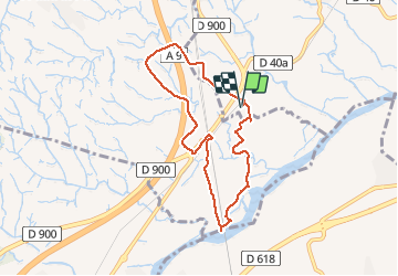
66 LE BOULOU - plans de NIDOLÈRES - poste électrique - auberge - vue sur les Albères - hameau de NIDOLÈRES, rue St éloi, place st Étienne, mas ste Lucie, rue du moulin, mon. Ste Lucie - le Tech - ouvrage d'art et piste le long de la ligne TGV - pla de NIDOLÈRES - noeud auto-ferroviaire, passage sous la ligne TGV, traverser la ligne SNCF classique, la longer à côté de la RN9, jusqu'au rond point - El mas d'en Gaspar - mas Roca - mas Maillols - pont au dessus de l'A9 - mas d'en Costaseca - mas de la Palla - la Creu Verda
Localisation
Commentaires
Randonnées à proximité
![Randonnée Marche Le Boulou - rando de la bataille du Boulou - Photo](https://media.geolcdn.com/t/375/260/aa2b3d38-bac5-4589-a4ac-8bd34f744e79.jpg&format=jpg&maxdim=2)
![Marche Marche](https://static1.geolcdn.com/sitytour/trail-icons/101.png)
Marche
![](/images/other/stat-length.png)
![](https://static1.geolcdn.com/siteimages/upload/files/16400158638029165_repeat_loop_refresh_sync_direction_icon.png)
![Randonnée Marche Montesquieu-des-Albères - MONTESQUIEU-DES-ALBERES 66 - Les Agouillous - les chemins de l'eau dans les Albères - Photo](https://media.geolcdn.com/t/375/260/ext.jpg?maxdim=2&url=https%3A%2F%2Fservices.sitytrail.com%2FGeolivesWS%2FDownloadMedia.ashx%3FTrailID%3D451257%26Media%3D20150728182708.jpg)
![Marche Marche](https://static1.geolcdn.com/sitytour/trail-icons/101.png)
Marche
![](/images/other/stat-length.png)
![](https://static1.geolcdn.com/siteimages/upload/files/16400158638029165_repeat_loop_refresh_sync_direction_icon.png)
![Randonnée Marche Le Boulou - LES THERMES DU BOULOU - 66 - Albera viva - PUIG de l'Estella - Photo](https://media.geolcdn.com/t/375/260/ext.jpg?maxdim=2&url=https%3A%2F%2Fservices.sitytrail.com%2FGeolivesWS%2FDownloadMedia.ashx%3FTrailID%3D443397%26Media%3D20150709200943.jpg)
![Marche Marche](https://static1.geolcdn.com/sitytour/trail-icons/101.png)
Marche
![](/images/other/stat-length.png)
![](https://static1.geolcdn.com/siteimages/upload/files/16400158638029165_repeat_loop_refresh_sync_direction_icon.png)
![Randonnée Marche Saint-Jean-Lasseille - ST-JEAN-LASSEILLE 66 - terroirs des Aspres - Photo](https://media.geolcdn.com/t/375/260/ext.jpg?maxdim=2&url=https%3A%2F%2Fservices.sitytrail.com%2FGeolivesWS%2FDownloadMedia.ashx%3FTrailID%3D419934%26Media%3D20150512183916.jpg)
![Marche Marche](https://static1.geolcdn.com/sitytour/trail-icons/101.png)
Marche
![](/images/other/stat-length.png)
![](https://static1.geolcdn.com/siteimages/upload/files/16400158638029165_repeat_loop_refresh_sync_direction_icon.png)
![Randonnée Marche Le Boulou - Bataille du Boulou (1793 - 1794) - Photo](https://media.geolcdn.com/t/375/260/e8fd6dc5-027d-40cc-9239-020c7f056093.jpg&format=jpg&maxdim=2)
![Marche Marche](https://static1.geolcdn.com/sitytour/trail-icons/101.png)
Marche
![](/images/other/stat-length.png)
![](https://static1.geolcdn.com/siteimages/upload/files/16400158638029165_repeat_loop_refresh_sync_direction_icon.png)
![Randonnée V.T.C. Le Boulou - Autour du Boulou (66) - Photo](https://media.geolcdn.com/t/375/260/1d105df1-7b05-435b-be16-23a1a2dd8321.jpg&format=jpg&maxdim=2)
![V.T.C. V.T.C.](https://static1.geolcdn.com/sitytour/trail-icons/203.png)
V.T.C.
![](/images/other/stat-length.png)
![](https://static1.geolcdn.com/siteimages/upload/files/16400158638029165_repeat_loop_refresh_sync_direction_icon.png)
![Randonnée Marche Le Boulou - Pic Estelle (377m) - Le Boulou - Pyrénées orientales (66) - Photo](https://media.geolcdn.com/t/375/260/e232faca-0036-4399-b7af-e7d27b87588b.jpg&format=jpg&maxdim=2)
![Marche Marche](https://static1.geolcdn.com/sitytour/trail-icons/101.png)
Marche
![](/images/other/stat-length.png)
![](https://static1.geolcdn.com/siteimages/upload/files/16400158638029165_repeat_loop_refresh_sync_direction_icon.png)
![Randonnée Marche Montesquieu-des-Albères - montesquieu . puig sant cristau . prieuré Santa maria del villard . montesquieu - Photo](https://media.geolcdn.com/t/375/260/ext.jpg?maxdim=2&url=https%3A%2F%2Fservices.sitytrail.com%2FGeolivesWS%2FDownloadMedia.ashx%3FTrailID%3D940648%26Media%3Dfix__20180410173102.jpg)
![Marche Marche](https://static1.geolcdn.com/sitytour/trail-icons/101.png)
Marche
![](/images/other/stat-length.png)
![](https://static1.geolcdn.com/siteimages/upload/files/16400158638029165_repeat_loop_refresh_sync_direction_icon.png)
![Randonnée Marche Brouilla - RP66 BROUILLA - BANYULS DELS ASPRES - par les bords de Tech et Vignobles - le 31.03.2017 - Photo](https://media.geolcdn.com/t/375/260/ext.jpg?maxdim=2&url=https%3A%2F%2Fstatic1.geolcdn.com%2Fsiteimages%2Fupload%2Ffiles%2F1553511878bg_sport_marche.png)
![Marche Marche](https://static1.geolcdn.com/sitytour/trail-icons/101.png)
Marche
![](/images/other/stat-length.png)
![](https://static1.geolcdn.com/siteimages/upload/files/16400158638029165_repeat_loop_refresh_sync_direction_icon.png)