![](/images/other/stat-length.png)
![Randonnée A pied Saint-Joachimsthal - [Ž] Klínovec - Radošov - Photo](https://media.geolcdn.com/t/1900/400/45832ed6-7d58-4e59-9ee7-9272ace5bf81.jpeg&format=pjpeg&maxdim=2)
[Ž] Klínovec - Radošov
SityTrail - itinéraires balisés pédestres
Tous les sentiers balisés d’Europe GUIDE+
![Longueur](/images/other/stat-length.png)
Longueur
18,9 km
![Altitude max](https://static1.geolcdn.com/siteimages/upload/files/1508320355ic_sort_altitude_max_24dp.png)
Altitude max
1243 m
![Dénivelé positif](https://static1.geolcdn.com/siteimages/upload/files/1508320355ic_sort_den_pos_24dp.png)
Dénivelé positif
186 m
![Km-Effort](/images/other/stat-length.png)
Km-Effort
24 km
![Altitude min](https://static1.geolcdn.com/siteimages/upload/files/1508320355ic_sort_altitude_min_24dp.png)
Altitude min
382 m
![Dénivelé négatif](https://static1.geolcdn.com/siteimages/upload/files/1508320355ic_sort_den_neg_24dp.png)
Dénivelé négatif
956 m
![Boucle](https://static1.geolcdn.com/siteimages/upload/files/16400158638029165_repeat_loop_refresh_sync_direction_icon.png)
Boucle
Non
Balise
Date de création :
2025-02-07 02:11:27.831
Dernière modification :
2025-02-07 02:11:27.831
![A pied](https://static1.geolcdn.com/sitytour/trail-icons/100.png)
5h26
Difficulté : Moyen
![Scannez ce code QR pour ouvrir la randonnée dans l'application SityTrail](https://capi.geolives.com/qq0zvz2zws4bq2lad0pu/sitytour/trails/4344444/qr.png?size=200)
Application GPS de randonnée GRATUITE
À propos
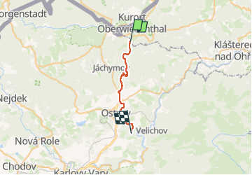
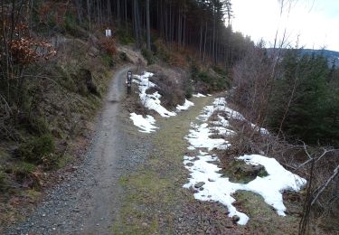
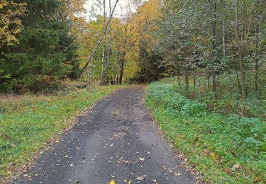
Randonnée A pied de 18,9 km à découvrir à Severozápad, Karlovarský kraj, Saint-Joachimsthal. Cette randonnée est proposée par SityTrail - itinéraires balisés pédestres.
Description
Randonnée créée par cz:KČT.
Localisation
Pays :
République Tchèque
Région :
Severozápad
Département/Province :
Karlovarský kraj
Commune :
Saint-Joachimsthal
Localité :
Unknown
Départ:(Dec)
Départ:(UTM)
355578 ; 5584596 (33U) N.
Commentaires
Randonnées à proximité
![Randonnée A pied Saint-Joachimsthal - naučná stezka Jáchymovské peklo - Photo](https://media.geolcdn.com/t/375/260/212b6420-01c3-4115-b8b8-7f484b00b4a3.jpeg&format=jpg&maxdim=2)
![A pied A pied](https://static1.geolcdn.com/sitytour/trail-icons/100.png)
naučná stezka Jáchymovské peklo
A pied
Facile
Saint-Joachimsthal,
Severozápad,
Karlovarský kraj,
République Tchèque
![](/images/other/stat-length.png)
8,4 km | 12,9 km-effort
2h 56min
![](https://static1.geolcdn.com/siteimages/upload/files/16400158638029165_repeat_loop_refresh_sync_direction_icon.png)
Oui
![Randonnée A pied Boží Dar - naučná stezka Božídarské rašeliniště - Photo](https://media.geolcdn.com/t/375/260/6698c15d-ee80-4a29-8d57-bf2742c4d239.jpeg&format=jpg&maxdim=2)
![A pied A pied](https://static1.geolcdn.com/sitytour/trail-icons/100.png)
naučná stezka Božídarské rašeliniště
A pied
Facile
Boží Dar,
Severozápad,
Karlovarský kraj,
République Tchèque
![](/images/other/stat-length.png)
3,3 km | 3,9 km-effort
53min
![](https://static1.geolcdn.com/siteimages/upload/files/16400158638029165_repeat_loop_refresh_sync_direction_icon.png)
Oui
![Randonnée A pied Loučná pod Klínovcem - NS Loučná pod Klínovcem - Photo](https://media.geolcdn.com/t/375/260/d91c1391-7cc2-4928-8108-a067e5e783aa.jpeg&format=jpg&maxdim=2)
![A pied A pied](https://static1.geolcdn.com/sitytour/trail-icons/100.png)
NS Loučná pod Klínovcem
A pied
Moyen
Loučná pod Klínovcem,
Severozápad,
Ústecký kraj,
République Tchèque
![](/images/other/stat-length.png)
17,1 km | 23 km-effort
5h 10min
![](https://static1.geolcdn.com/siteimages/upload/files/16400158638029165_repeat_loop_refresh_sync_direction_icon.png)
Oui
![Randonnée A pied Saint-Joachimsthal - Hornická naučná stezka Dr. Jana Hlouška - Photo](https://media.geolcdn.com/t/375/260/9fd4827e-815b-4d6d-be28-8d4a257dff69.jpeg&format=jpg&maxdim=2)
![A pied A pied](https://static1.geolcdn.com/sitytour/trail-icons/100.png)
Hornická naučná stezka Dr. Jana Hlouška
A pied
Facile
Saint-Joachimsthal,
Severozápad,
Karlovarský kraj,
République Tchèque
![](/images/other/stat-length.png)
11,4 km | 17,1 km-effort
3h 53min
![](https://static1.geolcdn.com/siteimages/upload/files/16400158638029165_repeat_loop_refresh_sync_direction_icon.png)
Oui
![Randonnée A pied Saint-Joachimsthal - naučná stezka Montánní krajina Krušných hor - Photo](https://media.geolcdn.com/t/375/260/08a89af8-01cb-422c-8ff5-b3835d4a6cd2.jpeg&format=jpg&maxdim=2)
![A pied A pied](https://static1.geolcdn.com/sitytour/trail-icons/100.png)
naučná stezka Montánní krajina Krušných hor
A pied
Facile
Saint-Joachimsthal,
Severozápad,
Karlovarský kraj,
République Tchèque
![](/images/other/stat-length.png)
10,7 km | 15,6 km-effort
3h 32min
![](https://static1.geolcdn.com/siteimages/upload/files/16400158638029165_repeat_loop_refresh_sync_direction_icon.png)
Oui
![Randonnée A pied Oberwiesenthal - Ww Bächelhütte - Rittersgrün - Pöhla - Photo](https://media.geolcdn.com/t/375/260/ext.jpg?maxdim=2&url=https%3A%2F%2Fstatic1.geolcdn.com%2Fsiteimages%2Fupload%2Ffiles%2F1545311037marcheuse_200dpi.jpg)
![A pied A pied](https://static1.geolcdn.com/sitytour/trail-icons/100.png)
Ww Bächelhütte - Rittersgrün - Pöhla
A pied
Facile
Oberwiesenthal,
Saxe,
Erzgebirgskreis,
Allemagne
![](/images/other/stat-length.png)
14,9 km | 18 km-effort
4h 6min
![](https://static1.geolcdn.com/siteimages/upload/files/16400158638029165_repeat_loop_refresh_sync_direction_icon.png)
Non
![Randonnée A pied Oberwiesenthal - Ww Rotes Vorwerk - Pförtelstraße - Photo](https://media.geolcdn.com/t/375/260/ext.jpg?maxdim=2&url=https%3A%2F%2Fstatic1.geolcdn.com%2Fsiteimages%2Fupload%2Ffiles%2F1545311037marcheuse_200dpi.jpg)
![A pied A pied](https://static1.geolcdn.com/sitytour/trail-icons/100.png)
Ww Rotes Vorwerk - Pförtelstraße
A pied
Facile
Oberwiesenthal,
Saxe,
Erzgebirgskreis,
Allemagne
![](/images/other/stat-length.png)
3,9 km | 5,2 km-effort
1h 10min
![](https://static1.geolcdn.com/siteimages/upload/files/16400158638029165_repeat_loop_refresh_sync_direction_icon.png)
Non
![Randonnée A pied Oberwiesenthal - Eric-Frenzel-Tour - Photo](https://media.geolcdn.com/t/375/260/ext.jpg?maxdim=2&url=https%3A%2F%2Fstatic1.geolcdn.com%2Fsiteimages%2Fupload%2Ffiles%2F1545311037marcheuse_200dpi.jpg)
![A pied A pied](https://static1.geolcdn.com/sitytour/trail-icons/100.png)
Eric-Frenzel-Tour
A pied
Facile
Oberwiesenthal,
Saxe,
Erzgebirgskreis,
Allemagne
![](/images/other/stat-length.png)
3,5 km | 5,2 km-effort
1h 11min
![](https://static1.geolcdn.com/siteimages/upload/files/16400158638029165_repeat_loop_refresh_sync_direction_icon.png)
Oui