![](/images/other/stat-length.png)
![Randonnée Marche Conca - Punta d'Ortu 2023 - Photo](https://media.geolcdn.com/t/1900/400/fbc4a404-f948-45c7-b565-8d6e98cf4c79.jpg&format=pjpeg&maxdim=2)
Punta d'Ortu 2023
philippenl
Utilisateur
![Longueur](/images/other/stat-length.png)
![Altitude max](https://static1.geolcdn.com/siteimages/upload/files/1508320355ic_sort_altitude_max_24dp.png)
![Dénivelé positif](https://static1.geolcdn.com/siteimages/upload/files/1508320355ic_sort_den_pos_24dp.png)
![Km-Effort](/images/other/stat-length.png)
![Altitude min](https://static1.geolcdn.com/siteimages/upload/files/1508320355ic_sort_altitude_min_24dp.png)
![Dénivelé négatif](https://static1.geolcdn.com/siteimages/upload/files/1508320355ic_sort_den_neg_24dp.png)
![Boucle](https://static1.geolcdn.com/siteimages/upload/files/16400158638029165_repeat_loop_refresh_sync_direction_icon.png)
![Marche](https://static1.geolcdn.com/sitytour/trail-icons/101.png)
4h39
Difficulté : Difficile
![Scannez ce code QR pour ouvrir la randonnée dans l'application SityTrail](https://capi.geolives.com/qq0zvz2zws4bq2lad0pu/sitytour/trails/3556200/qr.png?size=200)
Application GPS de randonnée GRATUITE
À propos
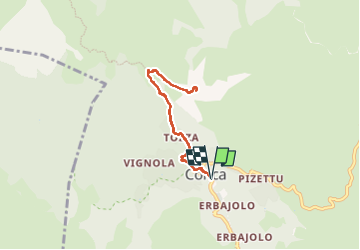
Randonnée Marche de 6,6 km à découvrir à Corse, Corse-du-Sud, Conca. Cette randonnée est proposée par philippenl.
Description
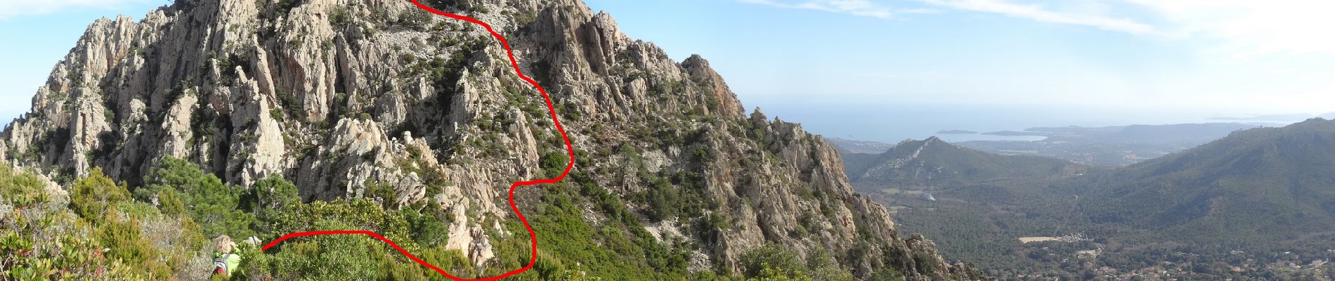
La Punta d'Ortu est la plus haute des trois pointes qui surplombent le village de Conca et sont visibles de partout. En conséquence, belvédère exceptionnel sur toute la micro région et en particulier le massif de Bavella.
Accès : par le GR20 depuis Conca. Quelques mètres avant Bocca d'Usciolu, prendre la trace à droite qui part vers l'est jusqu'au pied de la Punta d'Ortu. Quelques cairns épars jusqu'à un pierrier un peu à gauche après un replat et qu'il faut remonter jusqu'à un petit col : à droite en direction de la croix (point de vue à ne pas manquer) et à gauche en direction de la petite plate-forme du sommet. Vues 360 à couper le souffle.
Difficulté : quelques passages où les mains sont nécessaires, aucun équipement particulier requis si ce n'est les bâtons pour la redescente dans le pierrier.
Localisation
Commentaires
Randonnées à proximité
![Randonnée Marche Zonza - 2023-06-23 Balade Les trois piscines de Cavu - Photo](https://media.geolcdn.com/t/375/260/80ff9d7c-1f74-4902-8c44-ddec7e5d12ae.jpg&format=jpg&maxdim=2)
![Marche Marche](https://static1.geolcdn.com/sitytour/trail-icons/101.png)
Marche
![](/images/other/stat-length.png)
![](https://static1.geolcdn.com/siteimages/upload/files/16400158638029165_repeat_loop_refresh_sync_direction_icon.png)
![Randonnée Marche Zonza - balade qui monte beaucoup mais belle - Photo](https://media.geolcdn.com/t/375/260/79322bd2-e860-4301-91ab-9ce75398a470.jpg&format=jpg&maxdim=2)
![Marche Marche](https://static1.geolcdn.com/sitytour/trail-icons/101.png)
Marche
![](/images/other/stat-length.png)
![](https://static1.geolcdn.com/siteimages/upload/files/16400158638029165_repeat_loop_refresh_sync_direction_icon.png)
![Randonnée Marche Zonza - fautèa - lavu santu - Photo](https://media.geolcdn.com/t/375/260/8c0baaca-1606-49e6-a2ff-68e4a2182488.jpg&format=jpg&maxdim=2)
![Marche Marche](https://static1.geolcdn.com/sitytour/trail-icons/101.png)
Marche
![](/images/other/stat-length.png)
![](https://static1.geolcdn.com/siteimages/upload/files/16400158638029165_repeat_loop_refresh_sync_direction_icon.png)
![Randonnée Marche Zonza - boucle piscines Cavu - Photo](https://media.geolcdn.com/t/375/260/ext.jpg?maxdim=2&url=https%3A%2F%2Fstatic1.geolcdn.com%2Fsiteimages%2Fupload%2Ffiles%2F1553511878bg_sport_marche.png)
![Marche Marche](https://static1.geolcdn.com/sitytour/trail-icons/101.png)
Marche
![](/images/other/stat-length.png)
![](https://static1.geolcdn.com/siteimages/upload/files/16400158638029165_repeat_loop_refresh_sync_direction_icon.png)
![Randonnée Marche Zonza - Les baignoires naturelles - Photo](https://media.geolcdn.com/t/375/260/ext.jpg?maxdim=2&url=https%3A%2F%2Fstatic1.geolcdn.com%2Fsiteimages%2Fupload%2Ffiles%2F1553511878bg_sport_marche.png)
![Marche Marche](https://static1.geolcdn.com/sitytour/trail-icons/101.png)
Marche
![](/images/other/stat-length.png)
![](https://static1.geolcdn.com/siteimages/upload/files/16400158638029165_repeat_loop_refresh_sync_direction_icon.png)
![Randonnée Marche Zonza - la rivière du Cavu - Photo](https://media.geolcdn.com/t/375/260/ext.jpg?maxdim=2&url=https%3A%2F%2Fservices.sitytrail.com%2FGeolivesWS%2FDownloadMedia.ashx%3FTrailID%3D199050%26Media%3D4dd712c9-7b8e-4c6d-b767-cea357b59154.jpg)
![Marche Marche](https://static1.geolcdn.com/sitytour/trail-icons/101.png)
Marche
![](/images/other/stat-length.png)
![](https://static1.geolcdn.com/siteimages/upload/files/16400158638029165_repeat_loop_refresh_sync_direction_icon.png)
![Randonnée Trail Conca - Rr20 conca - Photo](https://media.geolcdn.com/t/375/260/1491c767-b3b3-41b0-815b-0fc1fb77a712.jpg&format=jpg&maxdim=2)
![Trail Trail](https://static1.geolcdn.com/sitytour/trail-icons/104.png)
![Randonnée Marche Zonza - Les trois fontaines - Photo](https://media.geolcdn.com/t/375/260/d2895e60-6206-4b20-a2c8-ac05013dde8b.jpg&format=jpg&maxdim=2)
![Marche Marche](https://static1.geolcdn.com/sitytour/trail-icons/101.png)
Marche
![](/images/other/stat-length.png)
![](https://static1.geolcdn.com/siteimages/upload/files/16400158638029165_repeat_loop_refresh_sync_direction_icon.png)
![Randonnée Vélo électrique Zonza - rando VTT des trois piscines - Photo](https://media.geolcdn.com/t/375/260/ext.jpg?maxdim=2&url=https%3A%2F%2Fstatic1.geolcdn.com%2Fsiteimages%2Fupload%2Ffiles%2F1524743154velo.jpg)
![Vélo électrique Vélo électrique](https://static1.geolcdn.com/sitytour/trail-icons/205.png)
Vélo électrique
![](/images/other/stat-length.png)
![](https://static1.geolcdn.com/siteimages/upload/files/16400158638029165_repeat_loop_refresh_sync_direction_icon.png)