![](/images/other/stat-length.png)
![Randonnée Marche Assesse - Crupet ADEPS très belle boucle via Bauche - Photo](https://media.geolcdn.com/t/1900/400/ext.pjpeg?maxdim=2&url=https%3A%2F%2Fstatic1.geolcdn.com%2Fsiteimages%2Fupload%2Ffiles%2F1553511878bg_sport_marche.png)
Crupet ADEPS très belle boucle via Bauche
thomarche
Utilisateur
![Longueur](/images/other/stat-length.png)
Longueur
8,6 km
![Altitude max](https://static1.geolcdn.com/siteimages/upload/files/1508320355ic_sort_altitude_max_24dp.png)
Altitude max
289 m
![Dénivelé positif](https://static1.geolcdn.com/siteimages/upload/files/1508320355ic_sort_den_pos_24dp.png)
Dénivelé positif
226 m
![Km-Effort](/images/other/stat-length.png)
Km-Effort
11,6 km
![Altitude min](https://static1.geolcdn.com/siteimages/upload/files/1508320355ic_sort_altitude_min_24dp.png)
Altitude min
117 m
![Dénivelé négatif](https://static1.geolcdn.com/siteimages/upload/files/1508320355ic_sort_den_neg_24dp.png)
Dénivelé négatif
233 m
![Boucle](https://static1.geolcdn.com/siteimages/upload/files/16400158638029165_repeat_loop_refresh_sync_direction_icon.png)
Boucle
Non
Date de création :
2022-08-21 12:32:57.0
Dernière modification :
2022-08-21 14:41:15.589
![Marche](https://static1.geolcdn.com/sitytour/trail-icons/101.png)
2h07
Difficulté : Inconnu
![Scannez ce code QR pour ouvrir la randonnée dans l'application SityTrail](https://capi.geolives.com/qq0zvz2zws4bq2lad0pu/sitytour/trails/3362729/qr.png?size=200)
Application GPS de randonnée GRATUITE
À propos
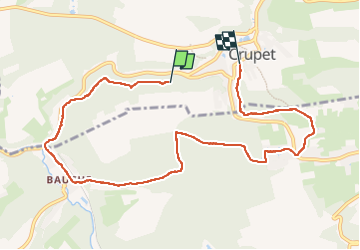
Randonnée Marche de 8,6 km à découvrir à Wallonie, Namur, Assesse. Cette randonnée est proposée par thomarche.
Description
Magnifique boucle via Bauche. Très peu macadam très peu fréquenté. Beaux chemins et sentiers. Vallonné et à flanc de coteau avec belles petites vues.
Localisation
Pays :
Belgique
Région :
Wallonie
Département/Province :
Namur
Commune :
Assesse
Localité :
Unknown
Départ:(Dec)
Départ:(UTM)
638502 ; 5578827 (31U) N.
Commentaires
Randonnées à proximité
![Randonnée Marche Profondeville - RL-GG-19_Lustin_Namur - Photo](https://media.geolcdn.com/t/375/260/b0b5ef2e-bf0c-4965-a3a2-62d0da2d07c7.jpg&format=jpg&maxdim=2)
![Marche Marche](https://static1.geolcdn.com/sitytour/trail-icons/101.png)
RL-GG-19_Lustin_Namur
Marche
Très difficile
(13)
Profondeville,
Wallonie,
Namur,
Belgique
![](/images/other/stat-length.png)
22 km | 28 km-effort
6h 7min
![](https://static1.geolcdn.com/siteimages/upload/files/16400158638029165_repeat_loop_refresh_sync_direction_icon.png)
Non
![Marche Marche](https://static1.geolcdn.com/sitytour/trail-icons/101.png)
RB-Na-21_Mont
Marche
Très difficile
(6)
Yvoir,
Wallonie,
Namur,
Belgique
![](/images/other/stat-length.png)
22 km | 30 km-effort
6h 51min
![](https://static1.geolcdn.com/siteimages/upload/files/16400158638029165_repeat_loop_refresh_sync_direction_icon.png)
Oui
![Randonnée Marche Assesse - RB-Na-02_Crupet_via-racc - Photo](https://media.geolcdn.com/t/375/260/ext.jpg?maxdim=2&url=https%3A%2F%2Fservices.sitytrail.com%2FGeolivesWS%2FDownloadMedia.ashx%3FTrailID%3D794014%26Media%3Dc4c97e29-7bfb-495c-ae56-13528ce8d0b3.JPG)
![Marche Marche](https://static1.geolcdn.com/sitytour/trail-icons/101.png)
RB-Na-02_Crupet_via-racc
Marche
Moyen
(7)
Assesse,
Wallonie,
Namur,
Belgique
![](/images/other/stat-length.png)
17 km | 23 km-effort
5h 32min
![](https://static1.geolcdn.com/siteimages/upload/files/16400158638029165_repeat_loop_refresh_sync_direction_icon.png)
Oui
![Randonnée Marche Assesse - RB-Na-02_Crupet - Photo](https://media.geolcdn.com/t/375/260/ext.jpg?maxdim=2&url=https%3A%2F%2Fservices.sitytrail.com%2FGeolivesWS%2FDownloadMedia.ashx%3FTrailID%3D250531%26Media%3Dc4c97e29-7bfb-495c-ae56-13528ce8d0b3.JPG)
![Marche Marche](https://static1.geolcdn.com/sitytour/trail-icons/101.png)
RB-Na-02_Crupet
Marche
Moyen
(21)
Assesse,
Wallonie,
Namur,
Belgique
![](/images/other/stat-length.png)
21 km | 28 km-effort
5h 32min
![](https://static1.geolcdn.com/siteimages/upload/files/16400158638029165_repeat_loop_refresh_sync_direction_icon.png)
Oui
![Randonnée Marche Yvoir - RB-Na-03_Houx - Photo](https://media.geolcdn.com/t/375/260/ext.jpg?maxdim=2&url=https%3A%2F%2Fservices.sitytrail.com%2FGeolivesWS%2FDownloadMedia.ashx%3FTrailID%3D179628%26Media%3D8266bb1a-850d-41b8-8bad-8e0bd7c82bf9.jpg)
![Marche Marche](https://static1.geolcdn.com/sitytour/trail-icons/101.png)
RB-Na-03_Houx
Marche
Difficile
(11)
Yvoir,
Wallonie,
Namur,
Belgique
![](/images/other/stat-length.png)
22 km | 30 km-effort
7h 1min
![](https://static1.geolcdn.com/siteimages/upload/files/16400158638029165_repeat_loop_refresh_sync_direction_icon.png)
Oui
![Randonnée Marche Assesse - 05 Paysage condruzien - Photo](https://media.geolcdn.com/t/375/260/ext.jpg?maxdim=2&url=https%3A%2F%2Fservices.sitytrail.com%2FGeolivesWS%2FDownloadMedia.ashx%3FTrailID%3D121392%26Media%3D31d83d0c-5bcd-44cd-b8d6-1cc6a3d25bf9.jpg)
![Marche Marche](https://static1.geolcdn.com/sitytour/trail-icons/101.png)
05 Paysage condruzien
Marche
Facile
(5)
Assesse,
Wallonie,
Namur,
Belgique
![](/images/other/stat-length.png)
10,2 km | 13,3 km-effort
2h 11min
![](https://static1.geolcdn.com/siteimages/upload/files/16400158638029165_repeat_loop_refresh_sync_direction_icon.png)
Non
![Marche Marche](https://static1.geolcdn.com/sitytour/trail-icons/101.png)
RB-Na-21_Mont_via-racc
Marche
Très difficile
(4)
Yvoir,
Wallonie,
Namur,
Belgique
![](/images/other/stat-length.png)
18,6 km | 25 km-effort
5h 43min
![](https://static1.geolcdn.com/siteimages/upload/files/16400158638029165_repeat_loop_refresh_sync_direction_icon.png)
Oui
![Randonnée Marche Assesse - Promenade à Crupet - Photo](https://media.geolcdn.com/t/375/260/ext.jpg?maxdim=2&url=https%3A%2F%2Fservices.sitytrail.com%2FGeolivesWS%2FDownloadMedia.ashx%3FTrailID%3D532928%26Media%3De78ba70e-0d4d-4d8c-b509-37ad32b8d33e.jpg)
![Marche Marche](https://static1.geolcdn.com/sitytour/trail-icons/101.png)
Promenade à Crupet
Marche
Facile
(3)
Assesse,
Wallonie,
Namur,
Belgique
![](/images/other/stat-length.png)
8,3 km | 11,4 km-effort
2h 30min
![](https://static1.geolcdn.com/siteimages/upload/files/16400158638029165_repeat_loop_refresh_sync_direction_icon.png)
Oui
![Randonnée Marche Yvoir - Balade à Spontin - Photo](https://media.geolcdn.com/t/375/260/ext.jpg?maxdim=2&url=https%3A%2F%2Fservices.sitytrail.com%2FGeolivesWS%2FDownloadMedia.ashx%3FTrailID%3D437057%26Media%3D4788e304-dd7c-47cc-a067-745c9f490e74.JPG)
![Marche Marche](https://static1.geolcdn.com/sitytour/trail-icons/101.png)
Balade à Spontin
Marche
Très facile
(4)
Yvoir,
Wallonie,
Namur,
Belgique
![](/images/other/stat-length.png)
5 km | 6,2 km-effort
1h 20min
![](https://static1.geolcdn.com/siteimages/upload/files/16400158638029165_repeat_loop_refresh_sync_direction_icon.png)
Oui