![](/images/other/stat-length.png)
![Randonnée A pied Schlüchtern - BUND-Schlüchtern-Rundweg - Hauptroute - Photo](https://media.geolcdn.com/t/1900/400/dc0eba0c-d099-4d00-9c12-271c891696f1.jpeg&format=pjpeg&maxdim=2)
BUND-Schlüchtern-Rundweg - Hauptroute
SityTrail - itinéraires balisés pédestres
Tous les sentiers balisés d’Europe GUIDE+
![Longueur](/images/other/stat-length.png)
![Altitude max](https://static1.geolcdn.com/siteimages/upload/files/1508320355ic_sort_altitude_max_24dp.png)
![Dénivelé positif](https://static1.geolcdn.com/siteimages/upload/files/1508320355ic_sort_den_pos_24dp.png)
![Km-Effort](/images/other/stat-length.png)
![Altitude min](https://static1.geolcdn.com/siteimages/upload/files/1508320355ic_sort_altitude_min_24dp.png)
![Dénivelé négatif](https://static1.geolcdn.com/siteimages/upload/files/1508320355ic_sort_den_neg_24dp.png)
![Boucle](https://static1.geolcdn.com/siteimages/upload/files/16400158638029165_repeat_loop_refresh_sync_direction_icon.png)
![A pied](https://static1.geolcdn.com/sitytour/trail-icons/100.png)
14h33
Difficulté : Très difficile
![Scannez ce code QR pour ouvrir la randonnée dans l'application SityTrail](https://capi.geolives.com/qq0zvz2zws4bq2lad0pu/sitytour/trails/3100145/qr.png?size=200)
Application GPS de randonnée GRATUITE
À propos
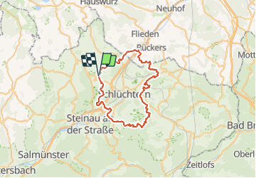
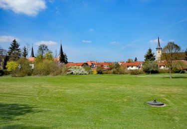
Randonnée A pied de 48 km à découvrir à Hesse, Main-Kinzig-Kreis, Schlüchtern. Cette randonnée est proposée par SityTrail - itinéraires balisés pédestres.
Description
Der 47 km lange Schlüchtern-Rundweg des BUND (Wegbeschreibung) zeigt Landschaft und Sehenswürdigkeiten im Umkreis der Bergwinkel-Stadt. Wanderer werden sich die Runde idealerweise in die drei vorgeschlagenen Etappen von 17, 12 und 18 km einteilen, wobei dann Anreise und Heimkehr zu/von Start und Ziel zu organisieren sind. Eine reizvolle Alternative bieten die 7 Zubringer- und Rückführwege,…
Site web: https://schluechtern.wordpress.com/about/
Localisation
Commentaires
Randonnées à proximité
![Randonnée A pied Steinau an der Straße - Ulmbach - Rundwanderweg UW - Photo](https://media.geolcdn.com/t/375/260/33246466-00bd-49e4-9abf-e59a98c78973.jpeg&format=jpg&maxdim=2)
![A pied A pied](https://static1.geolcdn.com/sitytour/trail-icons/100.png)
A pied
![](/images/other/stat-length.png)
![](https://static1.geolcdn.com/siteimages/upload/files/16400158638029165_repeat_loop_refresh_sync_direction_icon.png)
![Randonnée A pied Schlüchtern - BUND-Schlüchtern-Rundweg 7 - Photo](https://media.geolcdn.com/t/375/260/1a367717-348e-48b6-90c0-72ccb4fd28ee.jpeg&format=jpg&maxdim=2)
![A pied A pied](https://static1.geolcdn.com/sitytour/trail-icons/100.png)
A pied
![](/images/other/stat-length.png)
![](https://static1.geolcdn.com/siteimages/upload/files/16400158638029165_repeat_loop_refresh_sync_direction_icon.png)
![Randonnée A pied Schlüchtern - BUND-Schlüchtern-Rundweg 1 - Photo](https://media.geolcdn.com/t/375/260/96846348-56e8-41eb-ac74-99d018458889.jpeg&format=jpg&maxdim=2)
![A pied A pied](https://static1.geolcdn.com/sitytour/trail-icons/100.png)
A pied
![](/images/other/stat-length.png)
![](https://static1.geolcdn.com/siteimages/upload/files/16400158638029165_repeat_loop_refresh_sync_direction_icon.png)
![Randonnée A pied Schlüchtern - BUND-Schlüchtern-Rundweg 2 - Photo](https://media.geolcdn.com/t/375/260/91df87f9-846d-4ad6-988d-9c9f017be7f3.jpeg&format=jpg&maxdim=2)
![A pied A pied](https://static1.geolcdn.com/sitytour/trail-icons/100.png)
A pied
![](/images/other/stat-length.png)
![](https://static1.geolcdn.com/siteimages/upload/files/16400158638029165_repeat_loop_refresh_sync_direction_icon.png)
![Randonnée A pied Schlüchtern - BUND-Schlüchtern-Rundweg 4 - Photo](https://media.geolcdn.com/t/375/260/91df87f9-846d-4ad6-988d-9c9f017be7f3.jpeg&format=jpg&maxdim=2)
![A pied A pied](https://static1.geolcdn.com/sitytour/trail-icons/100.png)
A pied
![](/images/other/stat-length.png)
![](https://static1.geolcdn.com/siteimages/upload/files/16400158638029165_repeat_loop_refresh_sync_direction_icon.png)
![Randonnée A pied Schlüchtern - Schlüchtern Wanderweg SLÜ4 - Photo](https://media.geolcdn.com/t/375/260/630225c9-c620-44e6-8281-1a784b232469.jpeg&format=jpg&maxdim=2)
![A pied A pied](https://static1.geolcdn.com/sitytour/trail-icons/100.png)
A pied
![](/images/other/stat-length.png)
![](https://static1.geolcdn.com/siteimages/upload/files/16400158638029165_repeat_loop_refresh_sync_direction_icon.png)
![Randonnée A pied Schlüchtern - Schlüchtern Wanderweg SLÜ6 - Photo](https://media.geolcdn.com/t/375/260/630225c9-c620-44e6-8281-1a784b232469.jpeg&format=jpg&maxdim=2)
![A pied A pied](https://static1.geolcdn.com/sitytour/trail-icons/100.png)
A pied
![](/images/other/stat-length.png)
![](https://static1.geolcdn.com/siteimages/upload/files/16400158638029165_repeat_loop_refresh_sync_direction_icon.png)
![Randonnée A pied Schlüchtern - BUND-Schlüchtern-Rundweg 3 - Photo](https://media.geolcdn.com/t/375/260/91df87f9-846d-4ad6-988d-9c9f017be7f3.jpeg&format=jpg&maxdim=2)
![A pied A pied](https://static1.geolcdn.com/sitytour/trail-icons/100.png)
A pied
![](/images/other/stat-length.png)
![](https://static1.geolcdn.com/siteimages/upload/files/16400158638029165_repeat_loop_refresh_sync_direction_icon.png)
![Randonnée A pied Steinau an der Straße - Steinau a.d. Straße, Wanderweg 9 - Photo](https://media.geolcdn.com/t/375/260/ca94a906-55e3-4c1e-9b2f-5637afeef4b9.jpeg&format=jpg&maxdim=2)
![A pied A pied](https://static1.geolcdn.com/sitytour/trail-icons/100.png)
A pied
![](/images/other/stat-length.png)
![](https://static1.geolcdn.com/siteimages/upload/files/16400158638029165_repeat_loop_refresh_sync_direction_icon.png)