Randonnée A pied Lich - Kulturhistorischer Weg Muschenheim - Photo

Kulturhistorischer Weg Muschenheim

Tous les sentiers balisés d’Europe PRO

© OpenStreetMap contributors
Longueur
Longueur
3,3 km
Altitude max
Altitude max
187 m
Dénivelé positif
Dénivelé positif
52 m
Km-Effort
Km-Effort  
3,9 km
Altitude min
Altitude min
162 m
Dénivelé négatif
Dénivelé négatif
32 m
Boucle
Boucle
Non
Balise
Balise
Date de création :
2022-02-11 13:24:59.075
Dernière modification :
2022-02-11 13:24:59.075

(0 Avis)

A pied
A pied
53m
Difficulté : Facile

Scannez ce code QR pour ouvrir la randonnée dans l'application SityTrail

Application GPS de randonnée GRATUITE

Logo SityTrail SityTrail

IGN / Instituts géographiques

Télécharger SityTrail sur l'App Store Télécharger SityTrail sur Google Play

Logo SityTrail SityTrail World

Le monde est à vous

Télécharger SityTrail sur l'App Store Télécharger SityTrail sur Google Play Télécharger SityTrail sur Huawei AppGallery

À propos

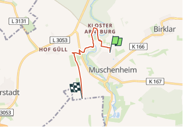
Randonnée A pied de 3,3 km à découvrir à Hesse, Landkreis Gießen, Lich. Cette randonnée est proposée par SityTrail - itinéraires balisés pédestres.

Description

Randonnée créée par Landkreis Gießen.

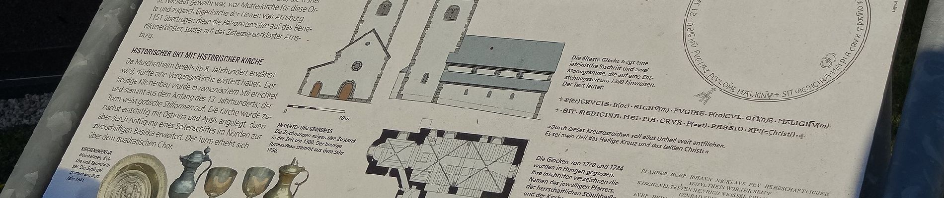
altes Symbol=Wappen von Muschenheim

Symbole: KHW

Photos

Localisation

Pays :
Allemagne
Région :
Hesse
Département/Province :
Landkreis Gießen
Commune :
Lich
Localité :
Unknown
Départ:(UTM)
485565 ; 5592992 (32U) N.

Randonnées à proximité

Randonnée A pied Lich - Residenzenring - Photo
A pied
PRO

A pied

Très difficile
Lich, Hesse, Landkreis Gießen, Allemagne
71 km | 88 km-effort
19h 59min
Oui


Fermer
Mes abonnements