


11,6 km | 16,5 km-effort


Randonnées du CGT GUIDE+


Application GPS de randonnée GRATUITE
 SityTrail
IGN / Instituts géographiques
SityTrail World
Le monde est à vous
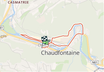
Randonnée A pied de 3,6 km à découvrir à Wallonie, Liège, Chaudfontaine. Cette randonnée est proposée par Commissariat général au Tourisme.
Randonnée créée par Ourthe Vesdre Amblève.
Comme son nom l'indique, cette promenade a pour but de donner rapidement et sans grand effort une vue de Chaudfontaine - Sources, de son cadre de verdure et des diverses installations qui en font un centre attractif, capable de satisfaire aux souhaits des visiteurs et des curistes.
Site web: https://organismes.tourismewallonie.be/details/ITB-01-000A5W&type=8/
 "
data-pinterest-text="Pin it"
data-tweet-text="share on twitter"
data-facebook-share-url="https://www.sitytrail.com/fr/trails/3080546-chaudfontaine--chaudfontaine-sources-x-xle-pietonnier-vertx/?photo=1#lg=1&slide=1"
data-twitter-share-url="https://www.sitytrail.com/fr/trails/3080546-chaudfontaine--chaudfontaine-sources-x-xle-pietonnier-vertx/?photo=1#lg=1&slide=1"
data-googleplus-share-url="https://www.sitytrail.com/fr/trails/3080546-chaudfontaine--chaudfontaine-sources-x-xle-pietonnier-vertx/?photo=1#lg=1&slide=1"
data-pinterest-share-url="https://www.sitytrail.com/fr/trails/3080546-chaudfontaine--chaudfontaine-sources-x-xle-pietonnier-vertx/?photo=1#lg=1&slide=1">
"
data-pinterest-text="Pin it"
data-tweet-text="share on twitter"
data-facebook-share-url="https://www.sitytrail.com/fr/trails/3080546-chaudfontaine--chaudfontaine-sources-x-xle-pietonnier-vertx/?photo=1#lg=1&slide=1"
data-twitter-share-url="https://www.sitytrail.com/fr/trails/3080546-chaudfontaine--chaudfontaine-sources-x-xle-pietonnier-vertx/?photo=1#lg=1&slide=1"
data-googleplus-share-url="https://www.sitytrail.com/fr/trails/3080546-chaudfontaine--chaudfontaine-sources-x-xle-pietonnier-vertx/?photo=1#lg=1&slide=1"
data-pinterest-share-url="https://www.sitytrail.com/fr/trails/3080546-chaudfontaine--chaudfontaine-sources-x-xle-pietonnier-vertx/?photo=1#lg=1&slide=1">
 "
data-pinterest-text="Pin it"
data-tweet-text="share on twitter"
data-facebook-share-url="https://www.sitytrail.com/fr/trails/3080546-chaudfontaine--chaudfontaine-sources-x-xle-pietonnier-vertx/?photo=2#lg=1&slide=2"
data-twitter-share-url="https://www.sitytrail.com/fr/trails/3080546-chaudfontaine--chaudfontaine-sources-x-xle-pietonnier-vertx/?photo=2#lg=1&slide=2"
data-googleplus-share-url="https://www.sitytrail.com/fr/trails/3080546-chaudfontaine--chaudfontaine-sources-x-xle-pietonnier-vertx/?photo=2#lg=1&slide=2"
data-pinterest-share-url="https://www.sitytrail.com/fr/trails/3080546-chaudfontaine--chaudfontaine-sources-x-xle-pietonnier-vertx/?photo=2#lg=1&slide=2">
"
data-pinterest-text="Pin it"
data-tweet-text="share on twitter"
data-facebook-share-url="https://www.sitytrail.com/fr/trails/3080546-chaudfontaine--chaudfontaine-sources-x-xle-pietonnier-vertx/?photo=2#lg=1&slide=2"
data-twitter-share-url="https://www.sitytrail.com/fr/trails/3080546-chaudfontaine--chaudfontaine-sources-x-xle-pietonnier-vertx/?photo=2#lg=1&slide=2"
data-googleplus-share-url="https://www.sitytrail.com/fr/trails/3080546-chaudfontaine--chaudfontaine-sources-x-xle-pietonnier-vertx/?photo=2#lg=1&slide=2"
data-pinterest-share-url="https://www.sitytrail.com/fr/trails/3080546-chaudfontaine--chaudfontaine-sources-x-xle-pietonnier-vertx/?photo=2#lg=1&slide=2">
 "
data-pinterest-text="Pin it"
data-tweet-text="share on twitter"
data-facebook-share-url="https://www.sitytrail.com/fr/trails/3080546-chaudfontaine--chaudfontaine-sources-x-xle-pietonnier-vertx/?photo=3#lg=1&slide=3"
data-twitter-share-url="https://www.sitytrail.com/fr/trails/3080546-chaudfontaine--chaudfontaine-sources-x-xle-pietonnier-vertx/?photo=3#lg=1&slide=3"
data-googleplus-share-url="https://www.sitytrail.com/fr/trails/3080546-chaudfontaine--chaudfontaine-sources-x-xle-pietonnier-vertx/?photo=3#lg=1&slide=3"
data-pinterest-share-url="https://www.sitytrail.com/fr/trails/3080546-chaudfontaine--chaudfontaine-sources-x-xle-pietonnier-vertx/?photo=3#lg=1&slide=3">
"
data-pinterest-text="Pin it"
data-tweet-text="share on twitter"
data-facebook-share-url="https://www.sitytrail.com/fr/trails/3080546-chaudfontaine--chaudfontaine-sources-x-xle-pietonnier-vertx/?photo=3#lg=1&slide=3"
data-twitter-share-url="https://www.sitytrail.com/fr/trails/3080546-chaudfontaine--chaudfontaine-sources-x-xle-pietonnier-vertx/?photo=3#lg=1&slide=3"
data-googleplus-share-url="https://www.sitytrail.com/fr/trails/3080546-chaudfontaine--chaudfontaine-sources-x-xle-pietonnier-vertx/?photo=3#lg=1&slide=3"
data-pinterest-share-url="https://www.sitytrail.com/fr/trails/3080546-chaudfontaine--chaudfontaine-sources-x-xle-pietonnier-vertx/?photo=3#lg=1&slide=3">
 "
data-pinterest-text="Pin it"
data-tweet-text="share on twitter"
data-facebook-share-url="https://www.sitytrail.com/fr/trails/3080546-chaudfontaine--chaudfontaine-sources-x-xle-pietonnier-vertx/?photo=4#lg=1&slide=4"
data-twitter-share-url="https://www.sitytrail.com/fr/trails/3080546-chaudfontaine--chaudfontaine-sources-x-xle-pietonnier-vertx/?photo=4#lg=1&slide=4"
data-googleplus-share-url="https://www.sitytrail.com/fr/trails/3080546-chaudfontaine--chaudfontaine-sources-x-xle-pietonnier-vertx/?photo=4#lg=1&slide=4"
data-pinterest-share-url="https://www.sitytrail.com/fr/trails/3080546-chaudfontaine--chaudfontaine-sources-x-xle-pietonnier-vertx/?photo=4#lg=1&slide=4">
"
data-pinterest-text="Pin it"
data-tweet-text="share on twitter"
data-facebook-share-url="https://www.sitytrail.com/fr/trails/3080546-chaudfontaine--chaudfontaine-sources-x-xle-pietonnier-vertx/?photo=4#lg=1&slide=4"
data-twitter-share-url="https://www.sitytrail.com/fr/trails/3080546-chaudfontaine--chaudfontaine-sources-x-xle-pietonnier-vertx/?photo=4#lg=1&slide=4"
data-googleplus-share-url="https://www.sitytrail.com/fr/trails/3080546-chaudfontaine--chaudfontaine-sources-x-xle-pietonnier-vertx/?photo=4#lg=1&slide=4"
data-pinterest-share-url="https://www.sitytrail.com/fr/trails/3080546-chaudfontaine--chaudfontaine-sources-x-xle-pietonnier-vertx/?photo=4#lg=1&slide=4">
 "
data-pinterest-text="Pin it"
data-tweet-text="share on twitter"
data-facebook-share-url="https://www.sitytrail.com/fr/trails/3080546-chaudfontaine--chaudfontaine-sources-x-xle-pietonnier-vertx/?photo=5#lg=1&slide=5"
data-twitter-share-url="https://www.sitytrail.com/fr/trails/3080546-chaudfontaine--chaudfontaine-sources-x-xle-pietonnier-vertx/?photo=5#lg=1&slide=5"
data-googleplus-share-url="https://www.sitytrail.com/fr/trails/3080546-chaudfontaine--chaudfontaine-sources-x-xle-pietonnier-vertx/?photo=5#lg=1&slide=5"
data-pinterest-share-url="https://www.sitytrail.com/fr/trails/3080546-chaudfontaine--chaudfontaine-sources-x-xle-pietonnier-vertx/?photo=5#lg=1&slide=5">
"
data-pinterest-text="Pin it"
data-tweet-text="share on twitter"
data-facebook-share-url="https://www.sitytrail.com/fr/trails/3080546-chaudfontaine--chaudfontaine-sources-x-xle-pietonnier-vertx/?photo=5#lg=1&slide=5"
data-twitter-share-url="https://www.sitytrail.com/fr/trails/3080546-chaudfontaine--chaudfontaine-sources-x-xle-pietonnier-vertx/?photo=5#lg=1&slide=5"
data-googleplus-share-url="https://www.sitytrail.com/fr/trails/3080546-chaudfontaine--chaudfontaine-sources-x-xle-pietonnier-vertx/?photo=5#lg=1&slide=5"
data-pinterest-share-url="https://www.sitytrail.com/fr/trails/3080546-chaudfontaine--chaudfontaine-sources-x-xle-pietonnier-vertx/?photo=5#lg=1&slide=5">
 "
data-pinterest-text="Pin it"
data-tweet-text="share on twitter"
data-facebook-share-url="https://www.sitytrail.com/fr/trails/3080546-chaudfontaine--chaudfontaine-sources-x-xle-pietonnier-vertx/?photo=6#lg=1&slide=6"
data-twitter-share-url="https://www.sitytrail.com/fr/trails/3080546-chaudfontaine--chaudfontaine-sources-x-xle-pietonnier-vertx/?photo=6#lg=1&slide=6"
data-googleplus-share-url="https://www.sitytrail.com/fr/trails/3080546-chaudfontaine--chaudfontaine-sources-x-xle-pietonnier-vertx/?photo=6#lg=1&slide=6"
data-pinterest-share-url="https://www.sitytrail.com/fr/trails/3080546-chaudfontaine--chaudfontaine-sources-x-xle-pietonnier-vertx/?photo=6#lg=1&slide=6">
"
data-pinterest-text="Pin it"
data-tweet-text="share on twitter"
data-facebook-share-url="https://www.sitytrail.com/fr/trails/3080546-chaudfontaine--chaudfontaine-sources-x-xle-pietonnier-vertx/?photo=6#lg=1&slide=6"
data-twitter-share-url="https://www.sitytrail.com/fr/trails/3080546-chaudfontaine--chaudfontaine-sources-x-xle-pietonnier-vertx/?photo=6#lg=1&slide=6"
data-googleplus-share-url="https://www.sitytrail.com/fr/trails/3080546-chaudfontaine--chaudfontaine-sources-x-xle-pietonnier-vertx/?photo=6#lg=1&slide=6"
data-pinterest-share-url="https://www.sitytrail.com/fr/trails/3080546-chaudfontaine--chaudfontaine-sources-x-xle-pietonnier-vertx/?photo=6#lg=1&slide=6">
 "
data-pinterest-text="Pin it"
data-tweet-text="share on twitter"
data-facebook-share-url="https://www.sitytrail.com/fr/trails/3080546-chaudfontaine--chaudfontaine-sources-x-xle-pietonnier-vertx/?photo=7#lg=1&slide=7"
data-twitter-share-url="https://www.sitytrail.com/fr/trails/3080546-chaudfontaine--chaudfontaine-sources-x-xle-pietonnier-vertx/?photo=7#lg=1&slide=7"
data-googleplus-share-url="https://www.sitytrail.com/fr/trails/3080546-chaudfontaine--chaudfontaine-sources-x-xle-pietonnier-vertx/?photo=7#lg=1&slide=7"
data-pinterest-share-url="https://www.sitytrail.com/fr/trails/3080546-chaudfontaine--chaudfontaine-sources-x-xle-pietonnier-vertx/?photo=7#lg=1&slide=7">
"
data-pinterest-text="Pin it"
data-tweet-text="share on twitter"
data-facebook-share-url="https://www.sitytrail.com/fr/trails/3080546-chaudfontaine--chaudfontaine-sources-x-xle-pietonnier-vertx/?photo=7#lg=1&slide=7"
data-twitter-share-url="https://www.sitytrail.com/fr/trails/3080546-chaudfontaine--chaudfontaine-sources-x-xle-pietonnier-vertx/?photo=7#lg=1&slide=7"
data-googleplus-share-url="https://www.sitytrail.com/fr/trails/3080546-chaudfontaine--chaudfontaine-sources-x-xle-pietonnier-vertx/?photo=7#lg=1&slide=7"
data-pinterest-share-url="https://www.sitytrail.com/fr/trails/3080546-chaudfontaine--chaudfontaine-sources-x-xle-pietonnier-vertx/?photo=7#lg=1&slide=7">
 "
data-pinterest-text="Pin it"
data-tweet-text="share on twitter"
data-facebook-share-url="https://www.sitytrail.com/fr/trails/3080546-chaudfontaine--chaudfontaine-sources-x-xle-pietonnier-vertx/?photo=8#lg=1&slide=8"
data-twitter-share-url="https://www.sitytrail.com/fr/trails/3080546-chaudfontaine--chaudfontaine-sources-x-xle-pietonnier-vertx/?photo=8#lg=1&slide=8"
data-googleplus-share-url="https://www.sitytrail.com/fr/trails/3080546-chaudfontaine--chaudfontaine-sources-x-xle-pietonnier-vertx/?photo=8#lg=1&slide=8"
data-pinterest-share-url="https://www.sitytrail.com/fr/trails/3080546-chaudfontaine--chaudfontaine-sources-x-xle-pietonnier-vertx/?photo=8#lg=1&slide=8">
"
data-pinterest-text="Pin it"
data-tweet-text="share on twitter"
data-facebook-share-url="https://www.sitytrail.com/fr/trails/3080546-chaudfontaine--chaudfontaine-sources-x-xle-pietonnier-vertx/?photo=8#lg=1&slide=8"
data-twitter-share-url="https://www.sitytrail.com/fr/trails/3080546-chaudfontaine--chaudfontaine-sources-x-xle-pietonnier-vertx/?photo=8#lg=1&slide=8"
data-googleplus-share-url="https://www.sitytrail.com/fr/trails/3080546-chaudfontaine--chaudfontaine-sources-x-xle-pietonnier-vertx/?photo=8#lg=1&slide=8"
data-pinterest-share-url="https://www.sitytrail.com/fr/trails/3080546-chaudfontaine--chaudfontaine-sources-x-xle-pietonnier-vertx/?photo=8#lg=1&slide=8">
 "
data-pinterest-text="Pin it"
data-tweet-text="share on twitter"
data-facebook-share-url="https://www.sitytrail.com/fr/trails/3080546-chaudfontaine--chaudfontaine-sources-x-xle-pietonnier-vertx/?photo=9#lg=1&slide=9"
data-twitter-share-url="https://www.sitytrail.com/fr/trails/3080546-chaudfontaine--chaudfontaine-sources-x-xle-pietonnier-vertx/?photo=9#lg=1&slide=9"
data-googleplus-share-url="https://www.sitytrail.com/fr/trails/3080546-chaudfontaine--chaudfontaine-sources-x-xle-pietonnier-vertx/?photo=9#lg=1&slide=9"
data-pinterest-share-url="https://www.sitytrail.com/fr/trails/3080546-chaudfontaine--chaudfontaine-sources-x-xle-pietonnier-vertx/?photo=9#lg=1&slide=9">
"
data-pinterest-text="Pin it"
data-tweet-text="share on twitter"
data-facebook-share-url="https://www.sitytrail.com/fr/trails/3080546-chaudfontaine--chaudfontaine-sources-x-xle-pietonnier-vertx/?photo=9#lg=1&slide=9"
data-twitter-share-url="https://www.sitytrail.com/fr/trails/3080546-chaudfontaine--chaudfontaine-sources-x-xle-pietonnier-vertx/?photo=9#lg=1&slide=9"
data-googleplus-share-url="https://www.sitytrail.com/fr/trails/3080546-chaudfontaine--chaudfontaine-sources-x-xle-pietonnier-vertx/?photo=9#lg=1&slide=9"
data-pinterest-share-url="https://www.sitytrail.com/fr/trails/3080546-chaudfontaine--chaudfontaine-sources-x-xle-pietonnier-vertx/?photo=9#lg=1&slide=9">


Marche

Marche

Marche

Marche

Marche


Marche

Marche