![](/images/other/stat-length.png)
![Randonnée Ski de randonnée La Léchère - M'ont Bellacha NE par le col de l'arc - Photo](https://media.geolcdn.com/t/1900/400/acd0ad4d-2f46-40b1-855c-b14225fa6b76.jpg&format=pjpeg&maxdim=2)
M'ont Bellacha NE par le col de l'arc
nadd73
Utilisateur GUIDE
![Longueur](/images/other/stat-length.png)
Longueur
14,1 km
![Altitude max](https://static1.geolcdn.com/siteimages/upload/files/1508320355ic_sort_altitude_max_24dp.png)
Altitude max
2459 m
![Dénivelé positif](https://static1.geolcdn.com/siteimages/upload/files/1508320355ic_sort_den_pos_24dp.png)
Dénivelé positif
1531 m
![Km-Effort](/images/other/stat-length.png)
Km-Effort
35 km
![Altitude min](https://static1.geolcdn.com/siteimages/upload/files/1508320355ic_sort_altitude_min_24dp.png)
Altitude min
923 m
![Dénivelé négatif](https://static1.geolcdn.com/siteimages/upload/files/1508320355ic_sort_den_neg_24dp.png)
Dénivelé négatif
1529 m
![Boucle](https://static1.geolcdn.com/siteimages/upload/files/16400158638029165_repeat_loop_refresh_sync_direction_icon.png)
Boucle
Oui
Date de création :
2022-01-19 08:33:07.498
Dernière modification :
2022-01-19 17:27:25.645
![Ski de randonnée](https://static1.geolcdn.com/sitytour/trail-icons/503.png)
5h32
Difficulté : Difficile
![Scannez ce code QR pour ouvrir la randonnée dans l'application SityTrail](https://capi.geolives.com/qq0zvz2zws4bq2lad0pu/sitytour/trails/3057015/qr.png?size=200)
Application GPS de randonnée GRATUITE
À propos
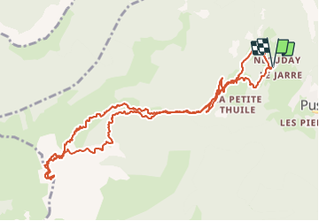
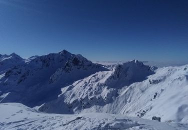
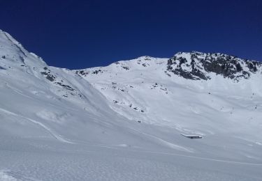
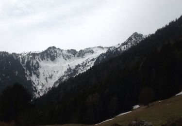
Randonnée Ski de randonnée de 14,1 km à découvrir à Auvergne-Rhône-Alpes, Savoie, La Léchère. Cette randonnée est proposée par nadd73.
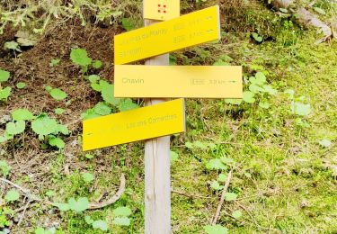
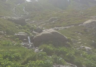
Description
Départ de Necuday.
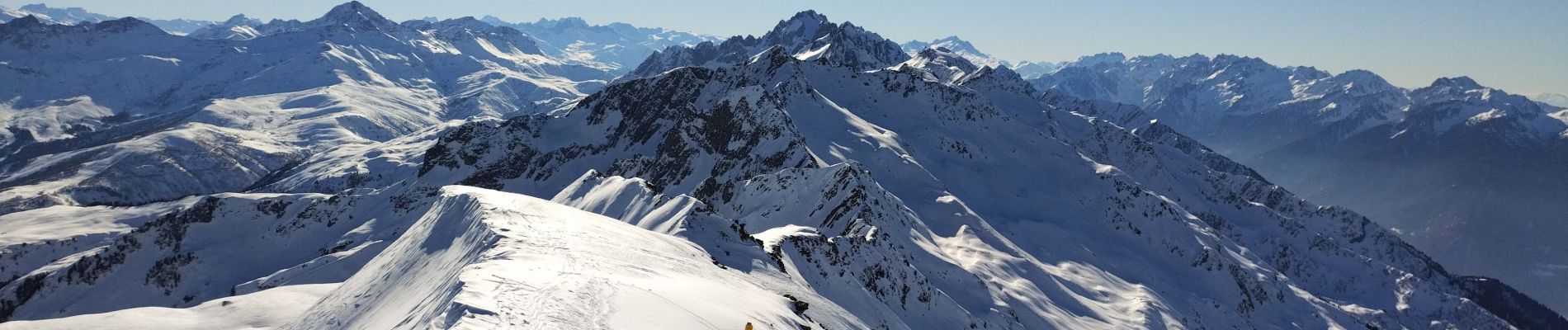
Je suis montée dans la combe des Charmettes. Mais il parait que c'est plus joli en passant par le col de l'arc et faire l'arête NO
prévoir crampons pour celle ci Sinon descente Idem
Localisation
Pays :
France
Région :
Auvergne-Rhône-Alpes
Département/Province :
Savoie
Commune :
La Léchère
Localité :
Pussy
Départ:(Dec)
Départ:(UTM)
300797 ; 5047899 (32T) N.
Commentaires
Randonnées à proximité
![Randonnée Marche La Léchère - pte de Glais rouge, des Arangles et Roche brisée - Photo](https://media.geolcdn.com/t/375/260/1baaaa90-37a8-4237-b92e-53be672474e7.jpg&format=jpg&maxdim=2)
![Marche Marche](https://static1.geolcdn.com/sitytour/trail-icons/101.png)
pte de Glais rouge, des Arangles et Roche brisée
Marche
Difficile
La Léchère,
Auvergne-Rhône-Alpes,
Savoie,
France
![](/images/other/stat-length.png)
9,3 km | 21 km-effort
4h 20min
![](https://static1.geolcdn.com/siteimages/upload/files/16400158638029165_repeat_loop_refresh_sync_direction_icon.png)
Oui
![Randonnée Marche La Léchère - les marmottes noires et Bellacha - Photo](https://media.geolcdn.com/t/375/260/2e4efe3f-cf03-4e44-8f86-163d48b8b315.jpg&format=jpg&maxdim=2)
![Marche Marche](https://static1.geolcdn.com/sitytour/trail-icons/101.png)
les marmottes noires et Bellacha
Marche
Moyen
La Léchère,
Auvergne-Rhône-Alpes,
Savoie,
France
![](/images/other/stat-length.png)
12,2 km | 27 km-effort
5h 25min
![](https://static1.geolcdn.com/siteimages/upload/files/16400158638029165_repeat_loop_refresh_sync_direction_icon.png)
Oui
![Randonnée Ski de randonnée La Léchère - pointe des Arangles - Photo](https://media.geolcdn.com/t/375/260/a96ea998-d04d-4c65-91bd-0ecac67dba45.jpg&format=jpg&maxdim=2)
![Ski de randonnée Ski de randonnée](https://static1.geolcdn.com/sitytour/trail-icons/503.png)
pointe des Arangles
Ski de randonnée
Moyen
La Léchère,
Auvergne-Rhône-Alpes,
Savoie,
France
![](/images/other/stat-length.png)
12,9 km | 29 km-effort
5h 30min
![](https://static1.geolcdn.com/siteimages/upload/files/16400158638029165_repeat_loop_refresh_sync_direction_icon.png)
Oui
![Randonnée Ski de randonnée Saint-Paul-sur-Isère - la thuile - Photo](https://media.geolcdn.com/t/375/260/78c5e4fd-0662-4c06-b9b7-53ad35e01b3d.jpg&format=jpg&maxdim=2)
![Ski de randonnée Ski de randonnée](https://static1.geolcdn.com/sitytour/trail-icons/503.png)
la thuile
Ski de randonnée
Facile
Saint-Paul-sur-Isère,
Auvergne-Rhône-Alpes,
Savoie,
France
![](/images/other/stat-length.png)
11,4 km | 24 km-effort
5h 42min
![](https://static1.geolcdn.com/siteimages/upload/files/16400158638029165_repeat_loop_refresh_sync_direction_icon.png)
Oui
![Randonnée Marche Cevins - Cevins acte 1 - Photo](https://media.geolcdn.com/t/375/260/df16bca8-6038-410a-ae84-ccdb5cc186c6.jpg&format=jpg&maxdim=2)
![Marche Marche](https://static1.geolcdn.com/sitytour/trail-icons/101.png)
Cevins acte 1
Marche
Très difficile
Cevins,
Auvergne-Rhône-Alpes,
Savoie,
France
![](/images/other/stat-length.png)
18,3 km | 40 km-effort
5h 7min
![](https://static1.geolcdn.com/siteimages/upload/files/16400158638029165_repeat_loop_refresh_sync_direction_icon.png)
Oui
![Randonnée Marche La Léchère - Ronchat La Cudraz Navette Plan des Heures Balcon des Adrets de Tarentaise - Photo](https://media.geolcdn.com/t/375/260/31bbd3e5-7eb6-4ecd-afbb-fb24a4602b0f.jpg&format=jpg&maxdim=2)
![Marche Marche](https://static1.geolcdn.com/sitytour/trail-icons/101.png)
Ronchat La Cudraz Navette Plan des Heures Balcon des Adrets de Tarentaise
Marche
Difficile
La Léchère,
Auvergne-Rhône-Alpes,
Savoie,
France
![](/images/other/stat-length.png)
8,3 km | 13,7 km-effort
3h 0min
![](https://static1.geolcdn.com/siteimages/upload/files/16400158638029165_repeat_loop_refresh_sync_direction_icon.png)
Oui
![Randonnée Marche La Léchère - les pissus - Photo](https://media.geolcdn.com/t/375/260/c8a3585a-f711-4fc9-bf70-2f04757e5ddc.jpg&format=jpg&maxdim=2)
![Marche Marche](https://static1.geolcdn.com/sitytour/trail-icons/101.png)
les pissus
Marche
Très facile
La Léchère,
Auvergne-Rhône-Alpes,
Savoie,
France
![](/images/other/stat-length.png)
5,2 km | 10,9 km-effort
4h 11min
![](https://static1.geolcdn.com/siteimages/upload/files/16400158638029165_repeat_loop_refresh_sync_direction_icon.png)
Oui
![Randonnée Marche La Léchère - Necuday-La Tuile - Photo](https://media.geolcdn.com/t/375/260/ext.jpg?maxdim=2&url=https%3A%2F%2Fservices.sitytrail.com%2FGeolivesWS%2FDownloadMedia.ashx%3FTrailID%3D549311%26Media%3D20160404133641.jpg)
![Marche Marche](https://static1.geolcdn.com/sitytour/trail-icons/101.png)
Necuday-La Tuile
Marche
Facile
La Léchère,
Auvergne-Rhône-Alpes,
Savoie,
France
![](/images/other/stat-length.png)
10,9 km | 17,3 km-effort
3h 44min
![](https://static1.geolcdn.com/siteimages/upload/files/16400158638029165_repeat_loop_refresh_sync_direction_icon.png)
Oui
![Randonnée Marche La Léchère - Val Gélon - Lac du Loup - Photo](https://media.geolcdn.com/t/375/260/ext.jpg?maxdim=2&url=https%3A%2F%2Fstatic1.geolcdn.com%2Fsiteimages%2Fupload%2Ffiles%2F1553511878bg_sport_marche.png)
![Marche Marche](https://static1.geolcdn.com/sitytour/trail-icons/101.png)
Val Gélon - Lac du Loup
Marche
Difficile
La Léchère,
Auvergne-Rhône-Alpes,
Savoie,
France
![](/images/other/stat-length.png)
6,1 km | 12,2 km-effort
2h 10min
![](https://static1.geolcdn.com/siteimages/upload/files/16400158638029165_repeat_loop_refresh_sync_direction_icon.png)
Oui