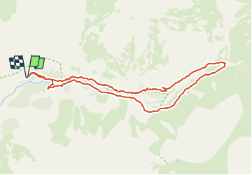
![](/images/other/stat-length.png)
![Randonnée Marche Champoléon - Champoléon - Refuge du pré de la Chaumette - Photo](https://media.geolcdn.com/t/1900/400/ext.pjpeg?maxdim=2&url=https%3A%2F%2Fstatic1.geolcdn.com%2Fsiteimages%2Fupload%2Ffiles%2F1553511878bg_sport_marche.png)
Champoléon - Refuge du pré de la Chaumette
pourrier
Utilisateur
![Longueur](/images/other/stat-length.png)
![Altitude max](https://static1.geolcdn.com/siteimages/upload/files/1508320355ic_sort_altitude_max_24dp.png)
![Dénivelé positif](https://static1.geolcdn.com/siteimages/upload/files/1508320355ic_sort_den_pos_24dp.png)
![Km-Effort](/images/other/stat-length.png)
![Altitude min](https://static1.geolcdn.com/siteimages/upload/files/1508320355ic_sort_altitude_min_24dp.png)
![Dénivelé négatif](https://static1.geolcdn.com/siteimages/upload/files/1508320355ic_sort_den_neg_24dp.png)
![Boucle](https://static1.geolcdn.com/siteimages/upload/files/16400158638029165_repeat_loop_refresh_sync_direction_icon.png)
![Marche](https://static1.geolcdn.com/sitytour/trail-icons/101.png)
3h31
Difficulté : Moyen
![Scannez ce code QR pour ouvrir la randonnée dans l'application SityTrail](https://capi.geolives.com/qq0zvz2zws4bq2lad0pu/sitytour/trails/2877174/qr.png?size=200)
Application GPS de randonnée GRATUITE
À propos
Randonnée Marche de 10 km à découvrir à Provence-Alpes-Côte d'Azur, Hautes-Alpes, Champoléon. Cette randonnée est proposée par pourrier.
Description
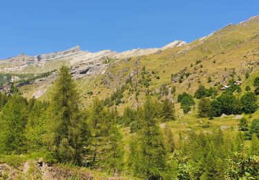
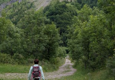
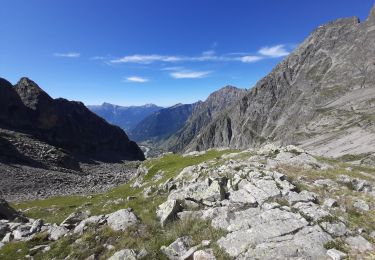
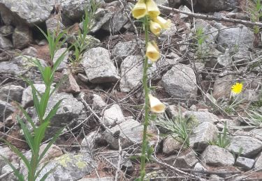
Belle promenade de 3h30 depuis le parking des Auberts jusqu'au refuge du Pré de la Chaumette.
Démarrage par un gros éboulis, situé sur la rive droite du Drac Blanc et ensuite le chemin est confortable.
Retour depuis le refuge par la rive gauche (piste pourriture montant au refuge) pour admirer la cascade des Prelles.
Localisation
Commentaires
Randonnées à proximité
![Randonnée Marche Champoléon - Lac de Prelles-Col du Cheval de bois - Photo](https://media.geolcdn.com/t/375/260/d8b66f59-3dd4-41c8-8493-8bdffe49ada9.jpg&format=jpg&maxdim=2)
![Marche Marche](https://static1.geolcdn.com/sitytour/trail-icons/101.png)
Marche
![](/images/other/stat-length.png)
![](https://static1.geolcdn.com/siteimages/upload/files/16400158638029165_repeat_loop_refresh_sync_direction_icon.png)
![Randonnée A pied Champoléon - Refuge du Tourond - Photo](https://media.geolcdn.com/t/375/260/42cbf5d1-e48d-4896-9483-7cb6a380b211.jpg&format=jpg&maxdim=2)
![A pied A pied](https://static1.geolcdn.com/sitytour/trail-icons/100.png)
A pied
![](/images/other/stat-length.png)
![](https://static1.geolcdn.com/siteimages/upload/files/16400158638029165_repeat_loop_refresh_sync_direction_icon.png)
![Randonnée Marche Champoléon - Méollion - Photo](https://media.geolcdn.com/t/375/260/da24cc78-a99a-4fa8-9dce-d97d6d7f39a5.jpg&format=jpg&maxdim=2)
![Marche Marche](https://static1.geolcdn.com/sitytour/trail-icons/101.png)
Marche
![](/images/other/stat-length.png)
![](https://static1.geolcdn.com/siteimages/upload/files/16400158638029165_repeat_loop_refresh_sync_direction_icon.png)
![Marche Marche](https://static1.geolcdn.com/sitytour/trail-icons/101.png)
Marche
![](/images/other/stat-length.png)
![](https://static1.geolcdn.com/siteimages/upload/files/16400158638029165_repeat_loop_refresh_sync_direction_icon.png)
![Randonnée Marche Champoléon - Balade Vallée Champoléon - Photo](https://media.geolcdn.com/t/375/260/23c779ce-adcf-411d-9db1-4b3234bce8ff.jpg&format=jpg&maxdim=2)
![Marche Marche](https://static1.geolcdn.com/sitytour/trail-icons/101.png)
Marche
![](/images/other/stat-length.png)
![](https://static1.geolcdn.com/siteimages/upload/files/16400158638029165_repeat_loop_refresh_sync_direction_icon.png)
![Randonnée Marche Champoléon - Refuge Tourond par Fermonds et Borels - Photo](https://media.geolcdn.com/t/375/260/e7d034e9-7e3b-42ad-9caa-76a3aa68be48.jpg&format=jpg&maxdim=2)
![Marche Marche](https://static1.geolcdn.com/sitytour/trail-icons/101.png)
Marche
![](/images/other/stat-length.png)
![](https://static1.geolcdn.com/siteimages/upload/files/16400158638029165_repeat_loop_refresh_sync_direction_icon.png)
![Randonnée Marche Champoléon - refuge du Tourond et cascade de la pisse - Photo](https://media.geolcdn.com/t/375/260/3023f38b-7f7f-4485-a753-4fb70a0a097f.jpg&format=jpg&maxdim=2)
![Marche Marche](https://static1.geolcdn.com/sitytour/trail-icons/101.png)
Marche
![](/images/other/stat-length.png)
![](https://static1.geolcdn.com/siteimages/upload/files/16400158638029165_repeat_loop_refresh_sync_direction_icon.png)
![Randonnée Marche Champoléon - PARC NATIONAL DES ECRINS: LACS DE CRUPILOUSE - Photo](https://media.geolcdn.com/t/375/260/ffca484e-6696-440e-b65f-eed34e1ad21b.jpg&format=jpg&maxdim=2)
![Marche Marche](https://static1.geolcdn.com/sitytour/trail-icons/101.png)
Marche
![](/images/other/stat-length.png)
![](https://static1.geolcdn.com/siteimages/upload/files/16400158638029165_repeat_loop_refresh_sync_direction_icon.png)
![Randonnée Marche Champoléon - Champoleon . - Photo](https://media.geolcdn.com/t/375/260/bc863020-364c-4571-8d00-7c075c354f01.jpg&format=jpg&maxdim=2)
![Marche Marche](https://static1.geolcdn.com/sitytour/trail-icons/101.png)
Marche
![](/images/other/stat-length.png)
![](https://static1.geolcdn.com/siteimages/upload/files/16400158638029165_repeat_loop_refresh_sync_direction_icon.png)