![](/images/other/stat-length.png)
![Randonnée Marche Oloron-Sainte-Marie - Pyrenees-Atl - Oloron-Ste-Marie St-Pee-d-en-Bas Col de Sabareil 19km 451m - Photo](https://media.geolcdn.com/t/1900/400/ext.pjpeg?maxdim=2&url=https%3A%2F%2Fstatic1.geolcdn.com%2Fsiteimages%2Fupload%2Ffiles%2F1553511878bg_sport_marche.png)
Pyrenees-Atl - Oloron-Ste-Marie St-Pee-d-en-Bas Col de Sabareil 19km 451m
RandoVal
Utilisateur
![Longueur](/images/other/stat-length.png)
Longueur
19,2 km
![Altitude max](https://static1.geolcdn.com/siteimages/upload/files/1508320355ic_sort_altitude_max_24dp.png)
Altitude max
480 m
![Dénivelé positif](https://static1.geolcdn.com/siteimages/upload/files/1508320355ic_sort_den_pos_24dp.png)
Dénivelé positif
614 m
![Km-Effort](/images/other/stat-length.png)
Km-Effort
27 km
![Altitude min](https://static1.geolcdn.com/siteimages/upload/files/1508320355ic_sort_altitude_min_24dp.png)
Altitude min
213 m
![Dénivelé négatif](https://static1.geolcdn.com/siteimages/upload/files/1508320355ic_sort_den_neg_24dp.png)
Dénivelé négatif
614 m
![Boucle](https://static1.geolcdn.com/siteimages/upload/files/16400158638029165_repeat_loop_refresh_sync_direction_icon.png)
Boucle
Oui
Date de création :
2020-09-07 07:08:33.427
Dernière modification :
2020-09-12 14:56:19.2
![Marche](https://static1.geolcdn.com/sitytour/trail-icons/101.png)
--
Difficulté : Inconnu
![Scannez ce code QR pour ouvrir la randonnée dans l'application SityTrail](https://capi.geolives.com/qq0zvz2zws4bq2lad0pu/sitytour/trails/2541242/qr.png?size=200)
Application GPS de randonnée GRATUITE
À propos
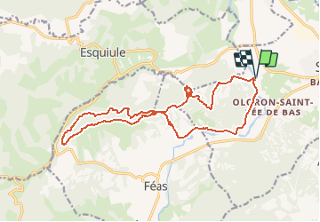
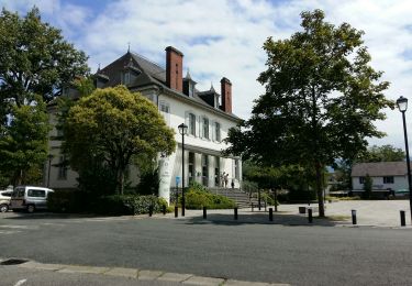
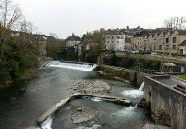
Randonnée Marche de 19,2 km à découvrir à Nouvelle-Aquitaine, Pyrénées-Atlantiques, Oloron-Sainte-Marie. Cette randonnée est proposée par RandoVal.
Description
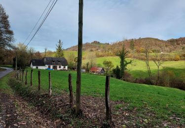
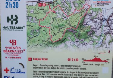
Boucle dans les Pyrennées, départ et stationnement au parcours de santé de St-Pée-d'en-Bas. sens anti-horaire. passage sur les gouffres de Harizpé.
Localisation
Pays :
France
Région :
Nouvelle-Aquitaine
Département/Province :
Pyrénées-Atlantiques
Commune :
Oloron-Sainte-Marie
Localité :
Unknown
Départ:(Dec)
Départ:(UTM)
691017 ; 4784211 (30T) N.
Commentaires
Randonnées à proximité
![Randonnée Course à pied Oloron-Sainte-Marie - OLORON Le camp de Cesar G4](https://media.geolcdn.com/t/375/260/e472b0d2-5d8f-43de-b167-1446063f7ed6.jpg&format=jpg&maxdim=2)
![Course à pied Course à pied](https://static1.geolcdn.com/sitytour/trail-icons/103.png)
OLORON Le camp de Cesar G4 "4022567"
Course à pied
Très facile
Oloron-Sainte-Marie,
Nouvelle-Aquitaine,
Pyrénées-Atlantiques,
France
![](/images/other/stat-length.png)
8,7 km | 12,4 km-effort
2h 58min
![](https://static1.geolcdn.com/siteimages/upload/files/16400158638029165_repeat_loop_refresh_sync_direction_icon.png)
Oui
![Randonnée A pied Oloron-Sainte-Marie - OLORON / LURBE - SAINT CHRISTAUD balisage GR 653 balisage - Photo](https://media.geolcdn.com/t/375/260/3e9828ef-bc7b-413a-8d74-e856dfe267ad.jpg&format=jpg&maxdim=2)
![A pied A pied](https://static1.geolcdn.com/sitytour/trail-icons/100.png)
OLORON / LURBE - SAINT CHRISTAUD balisage GR 653 balisage
A pied
Facile
Oloron-Sainte-Marie,
Nouvelle-Aquitaine,
Pyrénées-Atlantiques,
France
![](/images/other/stat-length.png)
12,9 km | 17,2 km-effort
3h 54min
![](https://static1.geolcdn.com/siteimages/upload/files/16400158638029165_repeat_loop_refresh_sync_direction_icon.png)
Non
![Randonnée Marche Oloron-Sainte-Marie - 2023 10 12 CHEMIN du PIÉMONT PYRÉNÉEN - 20ème étape 1ere partie : Oloron-Ste-Marie - Moumour - Orin - Géronce - St Goin - Gëus d’Oloron - l’Hopital st Blaise - Mauléon-Lichare. - Photo](https://media.geolcdn.com/t/375/260/ade2eb4a-a157-42cb-a64e-e7f217ca0550.jpg&format=jpg&maxdim=2)
![Marche Marche](https://static1.geolcdn.com/sitytour/trail-icons/101.png)
2023 10 12 CHEMIN du PIÉMONT PYRÉNÉEN - 20ème étape 1ere partie : Oloron-Ste...
Marche
Difficile
Oloron-Sainte-Marie,
Nouvelle-Aquitaine,
Pyrénées-Atlantiques,
France
![](/images/other/stat-length.png)
42 km | 54 km-effort
18h 1min
![](https://static1.geolcdn.com/siteimages/upload/files/16400158638029165_repeat_loop_refresh_sync_direction_icon.png)
Non
![Randonnée Marche Oloron-Sainte-Marie - OLORON ST MARIE Terra aventura - Photo](https://media.geolcdn.com/t/375/260/3d038a66-596b-48e0-83a1-a97e7a8939f0.jpg&format=jpg&maxdim=2)
![Marche Marche](https://static1.geolcdn.com/sitytour/trail-icons/101.png)
OLORON ST MARIE Terra aventura
Marche
Très facile
Oloron-Sainte-Marie,
Nouvelle-Aquitaine,
Pyrénées-Atlantiques,
France
![](/images/other/stat-length.png)
4,6 km | 6,1 km-effort
3h 18min
![](https://static1.geolcdn.com/siteimages/upload/files/16400158638029165_repeat_loop_refresh_sync_direction_icon.png)
Oui
![Randonnée A pied Oloron-Sainte-Marie - OLORON Ecomobilité](https://media.geolcdn.com/t/375/260/a50ee7db-7fec-4ab2-ad39-c73d7a339336.jpg&format=jpg&maxdim=2)
![A pied A pied](https://static1.geolcdn.com/sitytour/trail-icons/100.png)
OLORON Ecomobilité "Gare Goes Precilhon sentier de la chaux" 4h20 effectif 31...
A pied
Moyen
Oloron-Sainte-Marie,
Nouvelle-Aquitaine,
Pyrénées-Atlantiques,
France
![](/images/other/stat-length.png)
15,5 km | 20 km-effort
4h 20min
![](https://static1.geolcdn.com/siteimages/upload/files/16400158638029165_repeat_loop_refresh_sync_direction_icon.png)
Oui
![Randonnée V.T.T. Estos - Tour crètes jusqu'à Louvie - Photo](https://media.geolcdn.com/t/375/260/ext.jpg?maxdim=2&url=https%3A%2F%2Fstatic1.geolcdn.com%2Fsiteimages%2Fupload%2Ffiles%2F1524743154velo.jpg)
![V.T.T. V.T.T.](https://static1.geolcdn.com/sitytour/trail-icons/202.png)
Tour crètes jusqu'à Louvie
V.T.T.
Très difficile
(1)
Estos,
Nouvelle-Aquitaine,
Pyrénées-Atlantiques,
France
![](/images/other/stat-length.png)
58 km | 70 km-effort
4h 49min
![](https://static1.geolcdn.com/siteimages/upload/files/16400158638029165_repeat_loop_refresh_sync_direction_icon.png)
Non
![Randonnée Marche Ance-Féas - Ance Unars G3 2021 - Photo](https://media.geolcdn.com/t/375/260/5484398e-627e-4050-b331-9b372303d130.jpg&format=jpg&maxdim=2)
![Marche Marche](https://static1.geolcdn.com/sitytour/trail-icons/101.png)
Ance Unars G3 2021
Marche
Très difficile
Ance-Féas,
Nouvelle-Aquitaine,
Pyrénées-Atlantiques,
France
![](/images/other/stat-length.png)
13,3 km | 20 km-effort
3h 50min
![](https://static1.geolcdn.com/siteimages/upload/files/16400158638029165_repeat_loop_refresh_sync_direction_icon.png)
Oui
![Randonnée Marche Goès - hors G4 fait - Photo](https://media.geolcdn.com/t/375/260/602e6491-4cac-49f3-a61f-acdc5409b468.jpg&format=jpg&maxdim=2)
![Marche Marche](https://static1.geolcdn.com/sitytour/trail-icons/101.png)
hors G4 fait
Marche
Très facile
Goès,
Nouvelle-Aquitaine,
Pyrénées-Atlantiques,
France
![](/images/other/stat-length.png)
8,9 km | 12,1 km-effort
4h 36min
![](https://static1.geolcdn.com/siteimages/upload/files/16400158638029165_repeat_loop_refresh_sync_direction_icon.png)
Oui
![Randonnée Marche Oloron-Sainte-Marie - G4 Haut doloron - Photo](https://media.geolcdn.com/t/375/260/62971c8b-edeb-4f82-8ed6-042d0d814008.jpg&format=jpg&maxdim=2)
![Marche Marche](https://static1.geolcdn.com/sitytour/trail-icons/101.png)
G4 Haut doloron
Marche
Difficile
Oloron-Sainte-Marie,
Nouvelle-Aquitaine,
Pyrénées-Atlantiques,
France
![](/images/other/stat-length.png)
8,6 km | 12,3 km-effort
5h 14min
![](https://static1.geolcdn.com/siteimages/upload/files/16400158638029165_repeat_loop_refresh_sync_direction_icon.png)
Oui